1960s Maps of Caddo Parish, Louisiana
Explore 10 historic maps of Caddo Parish from the 1960s. These maps offer a rare glimpse into what life looked like during the 1960s — showing old roads, neighborhoods, homes, and landmarks that have changed or disappeared over time.
Whether you're researching your family's past, planning a metal detecting trip, or studying how Caddo Parish's landscape evolved across the 1960s, these high-resolution maps are a powerful tool for exploring the history of this region.
- Focus on a specific era: All maps on this page are from the 1960s, giving you a focused view of this time period.
- See what’s changed: Compare century-old streets, trails, and buildings to today's modern landscape using overlays and satellite layers.
- Research with precision: Use these maps for genealogy, historical research, land use analysis, or educational projects.
- View, download, or print: Maps are fully viewable online in high resolution, and can be downloaded or printed for your own records.
Start exploring Caddo Parish's history through authentic maps from the 1960s. This is your window into the past.
Caddo Parish, LA maps
(10)- 1960 Map of El Dorado
 1960 El Dorado1960 Print · USGSSouth Central Arkansas in the late fifties was a hub of energy production and defense industry. Researchers can trace the extensive Oil and Gas Fields around El Dorado or locate family landmarks like Old Park Cem and New Hope Church.
 - 1960 Map of North Highlands
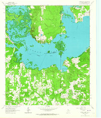
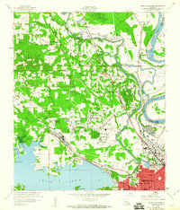 1960 North Highlands1960 Print · USGSShreveport and its northern suburbs reached toward the Red River in the early sixties as new infrastructure transformed the Caddo Parish landscape. Genealogists and local historians can trace the foundations of neighborhoods near Northside Sch, locate family plots at Walker Hill Cem, and follow the old rail lines of the Texas and Pacific.2 unique versions available
 - 1960 Map of Bossier City
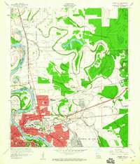 1960 Bossier City1960 Print · USGSBossier City and Shreveport are shown at a peak of post-war growth as the urban center expands toward the Red River. Researchers can trace mid-century neighborhoods near Plantation Park Sch or locate rural landmarks like Mt Zion Ch and Vanceville.2 unique versions available
 - 1962 Map of McLeod, 1963 Print
 1962 McLeod1963 Print · USGSThe Texas-Louisiana borderlands come into focus in the early sixties, showing a landscape defined by petroleum production and rural rail lines. Researchers can trace family sites and industry via the Kansas City Southern, Josey Cem, and the Refinery near North Rodessa.2 unique versions available
 - 1962 Map of Trees, 1963 Print
 1962 Trees1963 Print · USGSThe Texas-Louisiana borderlands come alive in this early 1960s survey of the James Bayou and Caddo Lake region. Genealogists and historians can trace numerous family burial sites like Burks-Hart Cem and the landings at Stacy Landing or Bonham Landing.2 unique versions available
 - 1962 Map of Potters Point, 1964 Print
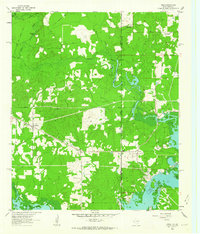
 1962 Potters Point1964 Print · USGSCaddo Lake and the borderlands of Texas and Louisiana appear here in the early sixties, showing a landscape defined by its bayous and early industry. Trace the historic landings and settlements of Uncertain, Swansons Landing, and the riverside Elizabeth Ch.3 unique versions available
 - 1962 Map of Panola, 1964 Print
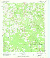
 1962 Panola1964 Print · USGSThe borderlands of Panola County and Caddo Parish are captured here in the early sixties as rural life met the growing energy industry. Genealogists and local historians can trace family sites like Jernigan Cem, Mt Zion Ch, and the De Berry Sch along the Old Railroad Grade.3 unique versions available
 - 1962 Map of Waskom, 1964 Print
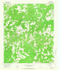
 1962 Waskom1964 Print · USGSThe borderlands of East Texas and Western Louisiana were a hub of railroad and petroleum activity in the early sixties. Genealogists and historians can trace the foundations of Waskom through local landmarks like Union Chapel and the Abney High Sch.4 unique versions available
 - 1962 Map of Latex, 1964 Print
 1962 Latex1964 Print · USGSThe Texas-Louisiana borderlands in the early sixties were a landscape defined by the intersection of the petroleum industry and deep-rooted rural life. Genealogists and local historians can trace family landmarks like the Old Border Church Cemetery, Jonesville School, and the settlement of Latex.3 unique versions available
 - 1969 Map of Ravanna, 1973 Print
 1969 Ravanna1973 Print · USGSThe tri-state border where Texas, Arkansas, and Louisiana meet comes alive in the late sixties, centered on the Rodessa Oil and Gas Field. Genealogists can trace family names through Beach Creek Cem and communities like Three States or Loutexark.2 unique versions available
End of results
Showing maps 1-10 of 10
Top cities of Caddo Parish
- Shreveport historical maps
- Vivian historical maps
- Blanchard historical maps
- Greenwood historical maps
- Oil City historical maps
- Mooringsport historical maps
See more
Frequently asked questions
- What are the different types of historical maps available for Caddo Parish?
- What is the oldest map of Caddo Parish?
- Where can I purchase historical maps of Caddo Parish for my home or office?
- Where can I download high-res historical maps of Caddo Parish?
- Are there historical topographic maps available for Caddo Parish?
- Is there historical aerial imagery available for Caddo Parish?
- Where are historical maps of Caddo Parish sourced from?