1970s Maps of Caddo Parish, Louisiana
Explore 16 historic maps of Caddo Parish from the 1970s. These maps offer a rare glimpse into what life looked like during the 1970s — showing old roads, neighborhoods, homes, and landmarks that have changed or disappeared over time.
Whether you're researching your family's past, planning a metal detecting trip, or studying how Caddo Parish's landscape evolved across the 1970s, these high-resolution maps are a powerful tool for exploring the history of this region.
- Focus on a specific era: All maps on this page are from the 1970s, giving you a focused view of this time period.
- See what’s changed: Compare century-old streets, trails, and buildings to today's modern landscape using overlays and satellite layers.
- Research with precision: Use these maps for genealogy, historical research, land use analysis, or educational projects.
- View, download, or print: Maps are fully viewable online in high resolution, and can be downloaded or printed for your own records.
Start exploring Caddo Parish's history through authentic maps from the 1970s. This is your window into the past.
Caddo Parish, LA maps
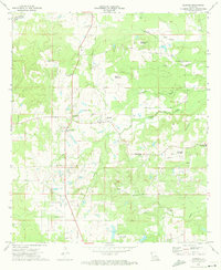
(16)- 1971 Map of Wardview, 1973 Print
 1971 Wardview1973 Print · USGSNorth Louisiana's river country is captured here in the early 1970s as the petroleum industry reshaped the rural landscape. Researchers can locate family landmarks like Bright Morning Star Ch, the Hosston Cem, and the shifting bends of the Red River.
 - 1971 Map of Vivian South, 1973 Print
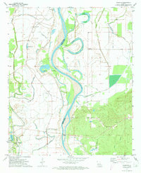
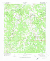
 1971 Vivian South1973 Print · USGSCaddo Parish in the early 1970s reveals a landscape defined by an extensive petroleum industry and a rich network of rural communities. Genealogists and historians can trace family roots through numerous sites like New Hope Cem, Mt Superior Ch, and the settlement at Oil City.2 unique versions available
 - 1971 Map of Gilliam, 1973 Print
 1971 Gilliam1973 Print · USGSThe Red River valley in the early 1970s shows a landscape of deep-rooted rural communities and heavy industry. Genealogists and historians can trace numerous country churches like St Elmo Ch and Union Chapel or locate the TEXAS AND PACIFIC rail stops at Cavett and Belcher.
 - 1971 Map of Vivian North, 1973 Print
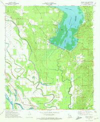
 1971 Vivian North1973 Print · USGSCaddo Parish in the early 1970s was a hub of energy production and rail transport, centered around the sprawling Black Bayou Lake. Genealogists and local historians can trace family roots through sites like Slaughter Cem, the North Caddo Community Sch, and the busy Rodessa Oil and Gas Field.
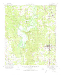
 - 1971 Map of Vivian, 1974 Print
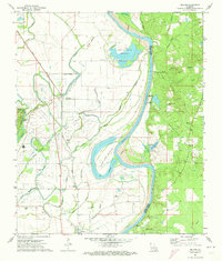
 1971 Vivian1974 Print · USGSCaddo Parish at the start of the 1970s shows a landscape transformed by the energy industry and an intricate network of bayous. Researchers can trace family sites at Centerville Cem and Antioch Ch or explore the rail hubs of Vivian and Oil City.2 unique versions available
 - 1972 Map of Gloster, 1974 Print
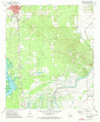
 1972 Gloster1974 Print · USGSDe Soto Parish's rural landscape is captured here in the early seventies, centered on the rail-side community of Gloster. Genealogists and local historians can trace family roots at Roseneath Plantation, Flower Hill Cem, and the Second Ward High Sch.
 - 1972 Map of Ringgold, 1974 Print
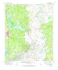
 1972 Ringgold1974 Print · USGSThe Louisiana parishes of Bossier, Webster, and Bienville are shown here in the early 1970s as industrial gas fields and lakeside recreation shaped the land. Genealogists can locate several local burial sites including Tooke Cem and Gilmer Cem, or trace the rail lines of the Kansas City Southern.
 - 1972 Map of Keatchie, 1974 Print
 1972 Keatchie1974 Print · USGSDe Soto and Caddo Parishes are shown in the early seventies as the energy industry and rural crossroads defined the landscape. Genealogists can trace family landmarks like Fullalove Cem and Mary Evergreen Ch near the village of Keatchie.
 - 1972 Map of Grand Cane, 1974 Print
 1972 Grand Cane1974 Print · USGSDe Soto and Caddo Parishes in the early 1970s reveal a landscape of rural plantation legacies and an expanding oil and gas industry. Genealogists can trace family names through dozens of landmarks like Roseneath Plantation, Mary Evergreen Ch, and the Fullalove Cem.
 - 1972 Map of Bossier Point, 1974 Print
 1972 Bossier Point1974 Print · USGSNorthwest Louisiana in the early seventies reveals a landscape of winding river bends and lake shorelines at the meeting of three parishes. Genealogists and local historians can locate family landmarks like Mt Nebo Ch and the Mary Magdalene Cem, or trace the rail lines through Cooterville and Ninock.2 unique versions available
 - 1975 Map of Bossier City, 1976 Print
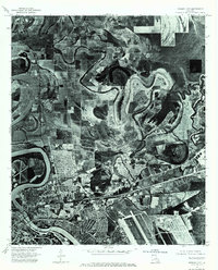 1975 Bossier City1976 Print · USGSBossier Parish and the Red River banks are captured in high-detail aerial photography during the mid-seventies growth of the Shreveport area. Researchers can trace the development of Bossier City, the sprawling footprint of Barksdale Air Force Base, and the rural character of Brownlee.3 unique versions available
 - 1975 Map of North Highlands, 1976 Print
 1975 North Highlands1976 Print · USGSNorthwestern Louisiana comes into focus in the mid-seventies as the urban landscape expands along the Red River corridor. Trace the shoreline of Cross Lake and the development of North Highlands in this detailed aerial perspective.
 - 1975 Map of Shreveport East, 1976 Print
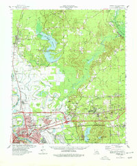
 1975 Shreveport East1976 Print · USGSShreveport and Bossier City appear during the mid-seventies, split by the winding course of the Red River. Researchers can trace the layout of Barksdale Air Force Base and the dense urban development within Shreveport.
 - 1975 Map of Shreveport West, 1976 Print
 1975 Shreveport West1976 Print · USGSShreveport's western suburbs and industrial corridors are captured in high detail during the mid-seventies in this aerial orthophotomap. Genealogists and local historians can trace residential growth near Cross Lake or examine the 1975 layout of Summer Grove and Shreveport.
 - 1978 Map of Bossier City
 1978 Bossier City1978 Print · USGSBossier City and its surrounding parishes are shown during a period of rapid development and infrastructure growth in the late seventies. Genealogists and local historians can trace family locations near Hillcrest Memorial Park Cem, the historic settlement of Bellevue, or the rural Macedonia Cem.2 unique versions available
 - 1979 Map of East Point, 1980 Print
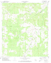
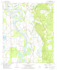 1979 East Point1980 Print · USGSRed River Parish in the late seventies is defined by the winding Red River and the rural communities clustered along its fertile banks. Genealogists and local historians can locate several country churches and cemeteries, including St Marks Cem, True Vine Ch, and the community of East Point.
End of results
Showing maps 1-16 of 16
Top cities of Caddo Parish
- Shreveport historical maps
- Vivian historical maps
- Blanchard historical maps
- Greenwood historical maps
- Oil City historical maps
- Mooringsport historical maps
See more
Frequently asked questions
- What are the different types of historical maps available for Caddo Parish?
- What is the oldest map of Caddo Parish?
- Where can I purchase historical maps of Caddo Parish for my home or office?
- Where can I download high-res historical maps of Caddo Parish?
- Are there historical topographic maps available for Caddo Parish?
- Is there historical aerial imagery available for Caddo Parish?
- Where are historical maps of Caddo Parish sourced from?