1990s Maps of Caddo Parish, Louisiana
Explore 3 historic maps of Caddo Parish from the 1990s. These maps offer a rare glimpse into what life looked like during the 1990s — showing old roads, neighborhoods, homes, and landmarks that have changed or disappeared over time.
Whether you're researching your family's past, planning a metal detecting trip, or studying how Caddo Parish's landscape evolved across the 1990s, these high-resolution maps are a powerful tool for exploring the history of this region.
- Focus on a specific era: All maps on this page are from the 1990s, giving you a focused view of this time period.
- See what’s changed: Compare century-old streets, trails, and buildings to today's modern landscape using overlays and satellite layers.
- Research with precision: Use these maps for genealogy, historical research, land use analysis, or educational projects.
- View, download, or print: Maps are fully viewable online in high resolution, and can be downloaded or printed for your own records.
Start exploring Caddo Parish's history through authentic maps from the 1990s. This is your window into the past.
Caddo Parish, LA maps
(3)- 1992 Map of Texarkana
 1992 Texarkana1992 Print · USGSThe Ark-La-Tex border region comes into focus in the early nineties, centered on the sprawling waters of Wright Patman Lake. Genealogists and historians can trace rail-town development and rural roots through Old Union Cem, the Red River Army Depot, and Dalby Springs Cem.
 - 1994 Map of Gloster, 1997 Print
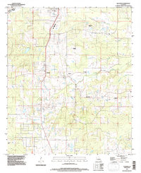 1994 Gloster1997 Print · USGSDe Soto Parish and the Caddo line come alive in the 1990s, showing a rural landscape shaped by large plantations and cross-parish bayous. Genealogists can trace family connections through Beauna Vista Plantation, Trinity Cem, and Gloster.
 - 1998 Map of Bossier City, 2003 Print
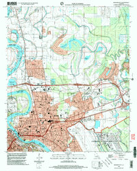 1998 Bossier City2003 Print · USGSBossier City and Shreveport's suburban expansion is captured in the late nineties as the urban landscape pushed into the Red River's oxbows. Researchers can locate family landmarks such as Greenwood Cemetery, St Judes Ch, and Rusheon Jr High Sch.
End of results
Showing maps 1-3 of 3
Top cities of Caddo Parish
- Shreveport historical maps
- Vivian historical maps
- Blanchard historical maps
- Greenwood historical maps
- Oil City historical maps
- Mooringsport historical maps
See more
Frequently asked questions
- What are the different types of historical maps available for Caddo Parish?
- What is the oldest map of Caddo Parish?
- Where can I purchase historical maps of Caddo Parish for my home or office?
- Where can I download high-res historical maps of Caddo Parish?
- Are there historical topographic maps available for Caddo Parish?
- Is there historical aerial imagery available for Caddo Parish?
- Where are historical maps of Caddo Parish sourced from?