1940s Maps of Lake Charles, Louisiana
Explore 4 historic maps of Lake Charles from the 1940s. These maps offer a rare glimpse into what life looked like during the 1940s — showing old roads, neighborhoods, homes, and landmarks that have changed or disappeared over time.
Whether you're researching your family's past, planning a metal detecting trip, or studying how Lake Charles's landscape evolved across the 1940s, these high-resolution maps are a powerful tool for exploring the history of this region.
- Focus on a specific era: All maps on this page are from the 1940s, giving you a focused view of this time period.
- See what’s changed: Compare century-old streets, trails, and buildings to today's modern landscape using overlays and satellite layers.
- Research with precision: Use these maps for genealogy, historical research, land use analysis, or educational projects.
- View, download, or print: Maps are fully viewable online in high resolution, and can be downloaded or printed for your own records.
Start exploring Lake Charles's history through authentic maps from the 1940s. This is your window into the past.
Lake Charles, LA maps
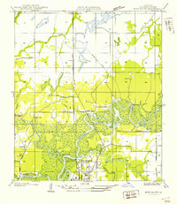
(4)- 1942 Map of Lake Charles
 1942 Lake Charles1942 Print · USGSLake Charles and the surrounding coastal prairies are captured here in the early 1940s, just as modern aviation and industrial shipping were reshaping the parish. Genealogists can locate family landmarks like Higgins School, Sweet Lake Church, and the neighborhood of Goosport.
 - 1946 Map of Moss Lake
 1946 Moss Lake1946 Print · USGSThe coastal marshlands of southwest Louisiana come alive in the 1940s, showing a world of bayous and boat landings. Trace the early routes around Hackberry or locate historic sites like Ellender Ferry and Dutch Cove Cemetery along the river.
 - 1947 Map of Moss Bluff
 1947 Moss Bluff1947 Print · USGSCalcasieu Parish's river-driven geography comes alive in this mid-century survey as the northern edge of Lake Charles begins to expand. Researchers can trace the era's vital river crossings at Goss Ferry and Perkins Ferry or locate the historic Ritchie Cem.
 - 1947 Map of West Lake
 1947 West Lake1947 Print · USGSCalcasieu Parish was undergoing significant maritime expansion just after the war, centered on the vital ship canal and river system. Genealogists and historians can trace family roots at Farquhar Cemetery, find the old Vincent Sch, or locate the historic Vincent Landing.
End of results
Showing maps 1-4 of 4
Top cities near Lake Charles
Top neighborhoods of Lake Charles
- Goosport historical maps
- Greinwich Village historical maps
- Pine Acres Trailer Park historical maps
- University Place historical maps
- The Ihles Townhomes historical maps
Frequently asked questions
- What are the different types of historical maps available for Lake Charles?
- What is the oldest map of Lake Charles?
- Where can I purchase historical maps of Lake Charles for my home or office?
- Where can I download high-res historical maps of Lake Charles?
- Are there historical topographic maps available for Lake Charles?
- Is there historical aerial imagery available for Lake Charles?
- Where are historical maps of Lake Charles sourced from?