1990s Maps of Claiborne Parish, Louisiana
Explore 2 historic maps of Claiborne Parish from the 1990s. These maps offer a rare glimpse into what life looked like during the 1990s — showing old roads, neighborhoods, homes, and landmarks that have changed or disappeared over time.
Whether you're researching your family's past, planning a metal detecting trip, or studying how Claiborne Parish's landscape evolved across the 1990s, these high-resolution maps are a powerful tool for exploring the history of this region.
- Focus on a specific era: All maps on this page are from the 1990s, giving you a focused view of this time period.
- See what’s changed: Compare century-old streets, trails, and buildings to today's modern landscape using overlays and satellite layers.
- Research with precision: Use these maps for genealogy, historical research, land use analysis, or educational projects.
- View, download, or print: Maps are fully viewable online in high resolution, and can be downloaded or printed for your own records.
Start exploring Claiborne Parish's history through authentic maps from the 1990s. This is your window into the past.
Claiborne Parish, LA maps
(2)- 1994 Map of Simsboro, 1995 Print
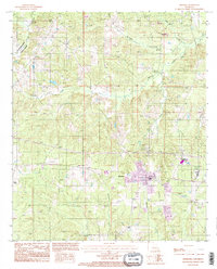 1994 Simsboro1995 Print · USGSIn the mid-nineties, the area around Simsboro and the Claiborne Parish line maintained a balance between its rural creek bottoms and emerging modern infrastructure. Researchers can trace local burial sites marked Cem, explore the course of the Dugdemona River, and find unique landmarks like the Ultralight Runway.
 - 1994 Map of Arcadia, 1995 Print
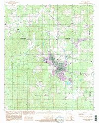 1994 Arcadia1995 Print · USGSArcadia and the surrounding piney woods of North Louisiana are shown here in the mid-1990s as the regional hub evolved. Genealogists and historians can locate rural settlements like Hurricane and Frazier or trace family landmarks like Bridges Mill.
End of results
Showing maps 1-2 of 2
Top cities of Claiborne Parish
Frequently asked questions
- What are the different types of historical maps available for Claiborne Parish?
- What is the oldest map of Claiborne Parish?
- Where can I purchase historical maps of Claiborne Parish for my home or office?
- Where can I download high-res historical maps of Claiborne Parish?
- Are there historical topographic maps available for Claiborne Parish?
- Is there historical aerial imagery available for Claiborne Parish?
- Where are historical maps of Claiborne Parish sourced from?