1970s Maps of DeSoto Parish, Louisiana
Explore 5 historic maps of DeSoto Parish from the 1970s. These maps offer a rare glimpse into what life looked like during the 1970s — showing old roads, neighborhoods, homes, and landmarks that have changed or disappeared over time.
Whether you're researching your family's past, planning a metal detecting trip, or studying how DeSoto Parish's landscape evolved across the 1970s, these high-resolution maps are a powerful tool for exploring the history of this region.
- Focus on a specific era: All maps on this page are from the 1970s, giving you a focused view of this time period.
- See what’s changed: Compare century-old streets, trails, and buildings to today's modern landscape using overlays and satellite layers.
- Research with precision: Use these maps for genealogy, historical research, land use analysis, or educational projects.
- View, download, or print: Maps are fully viewable online in high resolution, and can be downloaded or printed for your own records.
Start exploring DeSoto Parish's history through authentic maps from the 1970s. This is your window into the past.
DeSoto Parish, LA maps
(5)- 1972 Map of Gloster, 1974 Print
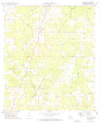
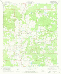 1972 Gloster1974 Print · USGSDe Soto Parish's rural landscape is captured here in the early seventies, centered on the rail-side community of Gloster. Genealogists and local historians can trace family roots at Roseneath Plantation, Flower Hill Cem, and the Second Ward High Sch.
 - 1972 Map of Grand Cane, 1974 Print
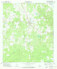 1972 Grand Cane1974 Print · USGSDe Soto Parish in the early seventies shows a community balancing its rural roots with a burgeoning energy industry. Researchers can find numerous country churches and cemeteries, such as Zion Hill Cem and Mary Evergreen Ch, alongside the Spider Gas Field.
 - 1972 Map of Keatchie, 1974 Print
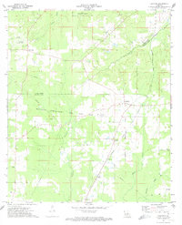 1972 Keatchie1974 Print · USGSDe Soto and Caddo Parishes are shown in the early seventies as the energy industry and rural crossroads defined the landscape. Genealogists can trace family landmarks like Fullalove Cem and Mary Evergreen Ch near the village of Keatchie.
 - 1972 Map of Grand Cane, 1974 Print
 1972 Grand Cane1974 Print · USGSDe Soto and Caddo Parishes in the early 1970s reveal a landscape of rural plantation legacies and an expanding oil and gas industry. Genealogists can trace family names through dozens of landmarks like Roseneath Plantation, Mary Evergreen Ch, and the Fullalove Cem.
 - 1972 Map of Longstreet, 1974 Print
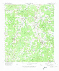
 1972 Longstreet1974 Print · USGSDe Soto Parish in the early seventies is a landscape of rural settlements and growing energy infrastructure. Genealogists and historians can trace family-named sites like Gamble Cem and Union Vine Ch alongside the Southern Pacific rail line.
End of results
Showing maps 1-5 of 5
Top cities of DeSoto Parish
- Mansfield historical maps
- Stonewall historical maps
- Logansport historical maps
- Grand Cane historical maps
- Longstreet historical maps
- Stanley historical maps
Frequently asked questions
- What are the different types of historical maps available for DeSoto Parish?
- What is the oldest map of DeSoto Parish?
- Where can I purchase historical maps of DeSoto Parish for my home or office?
- Where can I download high-res historical maps of DeSoto Parish?
- Are there historical topographic maps available for DeSoto Parish?
- Is there historical aerial imagery available for DeSoto Parish?
- Where are historical maps of DeSoto Parish sourced from?