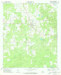
1972 Map of Grand Cane
USGS Topo · Published 1974About this map
The town of Grand Cane sits at the center of this early 1970s survey, surrounded by a landscape defined by both timbered creek bottoms and active energy extraction. The local topography is drained by a network of waterways including Cook Creek, Grand Cane Bayou, and Little Bayou Na Bonchasse, with the southern reaches transitioning into the broad Southerland Bottom. This era shows the extensive development of the regional energy industry, marked by the North Grand Cane Oil and Gas Field and the Spider Gas Field, with numerous pipelines and drill holes dotting the countryside.
Find a feature on this map
35 named features on this map. Tap any name to fly to it.
Don’t see what you’re looking for? This feature index may not catch every label — zoom into the map to look around manually.
Map Details
Editions of this 1972 Grand Cane Map
This is the sole edition of this map. No revisions or reprints were ever made.
Other maps of this area

1941 · Pelican
USGS Topo · 1:62,500

1943 · Pleasant Hill
USGS Topo · 1:62,500

1944 · Logansport
USGS Topo · 1:62,500

1944 · Pleasant Hill
USGS Topo · 1:62,500

1945 · Grand Cane
USGS Topo · 1:62,500

1945 · Mansfield
USGS Topo · 1:62,500

1947 · Mansfield
USGS Topo · 1:62,500

1953 · Alexandria
USGS Topo · 1:250,000

1955 · Shreveport
USGS Topo · 1:250,000

1955 · Alexandria
USGS Topo · 1:250,000