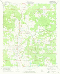
1972 Map of Gloster
USGS Topo · Published 1974About this map
Large agricultural holdings like Beauna Vista Plantation, Park Dota Plantation, and Roseneath Plantation define the rural landscape of De Soto Parish in the early 1970s. The settlement of Gloster serves as a central point along the Texas and Pacific Railroad, while the surrounding timber and farmland are dotted with small community landmarks including Bethlehem Ch, Morning Star Ch, and Second Ward High Sch.
Find a feature on this map
28 named features on this map. Tap any name to fly to it.
Don’t see what you’re looking for? This feature index may not catch every label — zoom into the map to look around manually.
Map Details
Editions of this 1972 Gloster Map
This is the sole edition of this map. No revisions or reprints were ever made.
Other maps of this area

1945 · Grand Cane
USGS Topo · 1:62,500

1945 · Greenwood
USGS Topo · 1:62,500

1945 · Mansfield
USGS Topo · 1:62,500

1947 · Mansfield
USGS Topo · 1:62,500

1948 · Caspiana
USGS Topo · 1:62,500

1955 · Shreveport
USGS Topo · 1:250,000

1955 · Caspiana
USGS Topo · 1:62,500

1955 · Greenwood
USGS Topo · 1:62,500

1956 · Shreveport
USGS Topo · 1:250,000
1957 · Grand Cane
USGS Topo · 1:62,500