1950s Maps of Grant Parish, Louisiana
Explore 12 historic maps of Grant Parish from the 1950s. These maps offer a rare glimpse into what life looked like during the 1950s — showing old roads, neighborhoods, homes, and landmarks that have changed or disappeared over time.
Whether you're researching your family's past, planning a metal detecting trip, or studying how Grant Parish's landscape evolved across the 1950s, these high-resolution maps are a powerful tool for exploring the history of this region.
- Focus on a specific era: All maps on this page are from the 1950s, giving you a focused view of this time period.
- See what’s changed: Compare century-old streets, trails, and buildings to today's modern landscape using overlays and satellite layers.
- Research with precision: Use these maps for genealogy, historical research, land use analysis, or educational projects.
- View, download, or print: Maps are fully viewable online in high resolution, and can be downloaded or printed for your own records.
Start exploring Grant Parish's history through authentic maps from the 1950s. This is your window into the past.
Grant Parish, LA maps
(12)- 1950 Map of Winnfield, 1960 Print
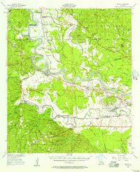
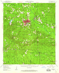 1950 Winnfield1960 Print · USGSNorth-central Louisiana centers on the timber and rail hub of Winnfield in the years following World War II. Genealogists and local historians can trace rural roots through landmarks like Sardis Ch, Crockett Cem, and the old rail siding at Carla.3 unique versions available
 - 1951 Map of Winnfield
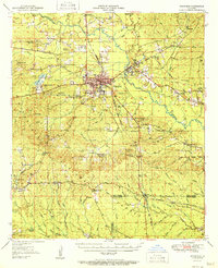 1951 Winnfield1951 Print · USGSMid-century Winn Parish is a landscape of timber and transit, where major rail lines intersect in the piney woods. Genealogists can locate family sites like McCarty Sch No 1, Morning Star Cem, and the small settlement at Tannehill.2 unique versions available
 - 1953 Map of Alexandria, 1963 Print
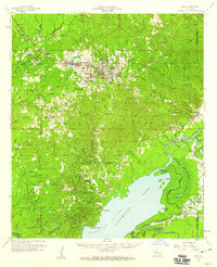
 1953 Alexandria1963 Print · USGSCentral Louisiana during the early fifties is mapped here at the intersection of the piney woods and the Red River valley. Genealogists and historians can trace the rail-and-river network connecting towns like Alexandria, Natchitoches, and the grounds of Camp Beauregard.3 unique versions available
 - 1954 Map of Tullos, 1955 Print
 1954 Tullos1955 Print · USGSLouisiana's timber and oil heartland comes to life in this mid-century survey of LaSalle and Winn Parishes. Genealogists and researchers can trace family roots through numerous rural landmarks like Zion Hill Ch, Adams Cem, and the rail settlements of Urania and Tullos.4 unique versions available
 - 1955 Map of Alexandria
 1955 Alexandria1955 Print · USGSCentral Louisiana in the mid-fifties is a landscape of river-port cities, sprawling timberlands, and massive military reservations. Genealogists and historians can trace the rail networks of the Texas & Pacific RR and locate sites like Camp Polk Military Reservation and Natchitoches.
 - 1956 Map of Colfax, 1957 Print
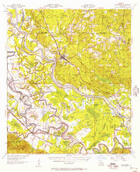
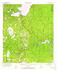
 1956 Colfax1957 Print · USGSGrant and Winn Parishes come into focus during the mid-1950s, showing a landscape defined by forest reserves and rail-line settlements. Genealogists and historians can trace local roots through landmarks like Hebron Ch & Cem, Summerfield Sch, and McNeeley.3 unique versions available
 - 1956 Map of Boyce, 1957 Print
 1956 Boyce1957 Print · USGSLouisiana's Red River valley in the mid-fifties reveals a landscape transitioning from traditional rail-and-river commerce to a burgeoning military presence. Trace family roots through dozens of rural sites like Hotwells, the Second Evening Star Ch, and Lacour Cem.3 unique versions available
 - 1957 Map of Montgomery
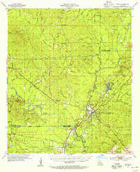
 1957 Montgomery1957 Print · USGSThe Red River valley in the mid-1950s was a landscape of intricate bayous and established river towns. Genealogists can trace family footprints through sites like Cloutierville, Glaizes Cem, and the many rural schools such as St Matthews Sch.3 unique versions available
 - 1957 Map of Alexandria, 1958 Print
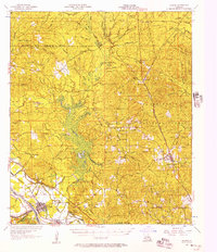
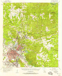 1957 Alexandria1958 Print · USGSThe Red River valley in the late fifties shows the post-war growth of Alexandria and Pineville amidst a landscape of military and state institutions. Genealogists and historians can locate dozens of neighborhood schools, cemeteries like Sardis Cem, and the early layout of Camp Beauregard.2 unique versions available
 - 1958 Map of Pollock, 1959 Print
 1958 Pollock1959 Print · USGSCentral Louisiana in the late fifties shows a landscape of parish river-crossings and timber-country rail lines. Researchers can trace the river landings at Thompson Ferry, the early infrastructure of Camp Hardtner, and rural life around White Sulphur Springs.3 unique versions available
 - 1958 Map of Jena, 1959 Print
 1958 Jena1959 Print · USGSLaSalle Parish timber and oil operations are in full swing during the late fifties, centered on the junction of the Louisiana and Arkansas Railway and the town of Jena. Researchers can trace family ties at the Nebo Sch, Searcy Cem, and the worker housing at Webb Quarters.2 unique versions available
 - 1959 Map of Buckeye, 1960 Print
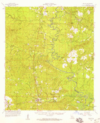
 1959 Buckeye1960 Print · USGSLouisiana parish lines converge in this late-fifties landscape of complex bayous and oil fields. Researchers can trace rural family roots through numerous local landmarks like Marthas Chapel, Guillory Cem, and the old settlement of Buckeye.2 unique versions available
End of results
Showing maps 1-12 of 12
Top cities of Grant Parish
- Colfax historical maps
- Montgomery historical maps
- Dry Prong historical maps
- Pollock historical maps
- Georgetown historical maps
Frequently asked questions
- What are the different types of historical maps available for Grant Parish?
- What is the oldest map of Grant Parish?
- Where can I purchase historical maps of Grant Parish for my home or office?
- Where can I download high-res historical maps of Grant Parish?
- Are there historical topographic maps available for Grant Parish?
- Is there historical aerial imagery available for Grant Parish?
- Where are historical maps of Grant Parish sourced from?