1970s Maps of Grant Parish, Louisiana
Explore 5 historic maps of Grant Parish from the 1970s. These maps offer a rare glimpse into what life looked like during the 1970s — showing old roads, neighborhoods, homes, and landmarks that have changed or disappeared over time.
Whether you're researching your family's past, planning a metal detecting trip, or studying how Grant Parish's landscape evolved across the 1970s, these high-resolution maps are a powerful tool for exploring the history of this region.
- Focus on a specific era: All maps on this page are from the 1970s, giving you a focused view of this time period.
- See what’s changed: Compare century-old streets, trails, and buildings to today's modern landscape using overlays and satellite layers.
- Research with precision: Use these maps for genealogy, historical research, land use analysis, or educational projects.
- View, download, or print: Maps are fully viewable online in high resolution, and can be downloaded or printed for your own records.
Start exploring Grant Parish's history through authentic maps from the 1970s. This is your window into the past.
Grant Parish, LA maps
(5)- 1971 Map of Boyce, 1973 Print
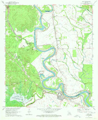 1971 Boyce1973 Print · USGSThe Red River valley in Rapides Parish comes alive in the early seventies, showing the vital rail and river networks of Boyce and Kateland. Researchers can trace family roots at Boyce Cem or St Aloysius Cem and locate rural landmarks like Magnolia Ch and Raven Camp Ch.3 unique versions available
 - 1972 Map of Ball, 1974 Print
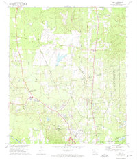 1972 Ball1974 Print · USGSRapides and Grant Parishes are captured here in the early seventies, dominated by the pine woods of the Kisatchie National Forest. Researchers can trace the military history of Camp Beauregard or locate local landmarks like Sardis Ch and the Pollock Municipal Airport.2 unique versions available
 - 1972 Map of Rock Hill, 1974 Print
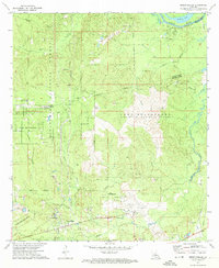
 1972 Rock Hill1974 Print · USGSGrant and Rapides Parishes are shown in the early 1970s, defined by the winding Red River and the Kisatchie National Forest. Genealogists and historians can locate family landmarks like Cruikshank Cem, Bagdad, and the Kansas City Southern rail line.2 unique versions available
 - 1972 Map of Holloway, 1974 Print
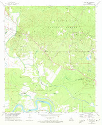
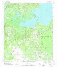 1972 Holloway1974 Print · USGSCentral Louisiana wetlands meet industrial expansion in the early 1970s as the Little River flows into the vast Catahoula Lake. Genealogists and local historians can trace the community of Holloway, locate Marthas Chapel, or follow the Old Railroad Grade through the bayous.3 unique versions available
 - 1972 Map of Green Gables, 1974 Print
 1972 Green Gables1974 Print · USGSRapides and Grant Parishes are captured in the early seventies, a landscape defined by the military grounds of Camp Beauregard and the Kisatchie National Forest. Researchers can trace the rural community of Green Gables, the airfield at ESLER FIELD, and local landmarks like Pheasant Grove Ch and Lofton Cem.2 unique versions available
End of results
Showing maps 1-5 of 5
Top cities of Grant Parish
- Colfax historical maps
- Montgomery historical maps
- Dry Prong historical maps
- Pollock historical maps
- Georgetown historical maps
Frequently asked questions
- What are the different types of historical maps available for Grant Parish?
- What is the oldest map of Grant Parish?
- Where can I purchase historical maps of Grant Parish for my home or office?
- Where can I download high-res historical maps of Grant Parish?
- Are there historical topographic maps available for Grant Parish?
- Is there historical aerial imagery available for Grant Parish?
- Where are historical maps of Grant Parish sourced from?