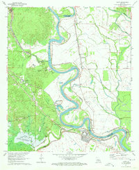
1971 Map of Boyce
USGS Topo · Published 1973About this map
The Red River winds through this central Louisiana landscape, marking the boundary between Rapides and Grant Parishes and defining the local economy of the early 1970s. The town of Boyce serves as a hub for both the Texas and Pacific Railroad and the Kansas City Southern Railway, while the nearby settlement of Kateland sits adjacent to the river's extensive levee system. This era shows the region's industrial and agricultural infrastructure, including the gaging station on the river and several gravel pits.
Find a feature on this map
61 named features on this map. Tap any name to fly to it.
Don’t see what you’re looking for? This feature index may not catch every label — zoom into the map to look around manually.
Map Details
Editions of this 1971 Boyce Map
3 editions found
Other maps of this area

1932 · Boyce NE
USGS Topo · 1:31,680

1932 · Boyce SW
USGS Topo · 1:31,680

1932 · Colfax SW
USGS Topo · 1:31,680

1932 · Colfax SE
USGS Topo · 1:31,680

1936 · Colfax
USGS Topo · 1:62,500

1937 · Chopin NE
USGS Topo · 1:31,680

1937 · Aloha
USGS Topo · 1:31,680

1937 · Montgomery
USGS Topo · 1:62,500

1937 · Chopin SE
USGS Topo · 1:31,680

1941 · Boyce
USGS Topo · 1:62,500