1890s Maps of Jefferson Parish, Louisiana
Explore 10 historic maps of Jefferson Parish from the 1890s. These maps offer a rare glimpse into what life looked like during the 1890s — showing old roads, neighborhoods, homes, and landmarks that have changed or disappeared over time.
Whether you're researching your family's past, planning a metal detecting trip, or studying how Jefferson Parish's landscape evolved across the 1890s, these high-resolution maps are a powerful tool for exploring the history of this region.
- Focus on a specific era: All maps on this page are from the 1890s, giving you a focused view of this time period.
- See what’s changed: Compare century-old streets, trails, and buildings to today's modern landscape using overlays and satellite layers.
- Research with precision: Use these maps for genealogy, historical research, land use analysis, or educational projects.
- View, download, or print: Maps are fully viewable online in high resolution, and can be downloaded or printed for your own records.
Start exploring Jefferson Parish's history through authentic maps from the 1890s. This is your window into the past.
Jefferson Parish, LA maps
(10)- 1891 Map of Hahnville
 1891 Hahnville1891 Print · USGSSt. Charles Parish was a hub of river and rail commerce in the late nineteenth century, where new tracks began to bridge the gap between New Orleans and the southern bayous. Researchers can trace historic riverfront tracts at Hahnville and Luling or locate family-named landings such as Pecan Grove and Loquer.5 unique versions available
 - 1891 Map of Spanish Fort
 1891 Spanish Fort1891 Print · USGSThe New Orleans lakefront in the early 1890s was a landscape of emerging rail hubs and shoreline outposts. Trace the early footprints of Milneburg, Spanish Fort, and the lighthouse stations along Lake Pontchartrain during this pivotal era of coastal growth.4 unique versions available
 - 1891 Map of Pointe a La Hache
 1891 Pointe a La Hache1891 Print · USGSCoastal Plaquemines Parish and the Mississippi River delta appear here in the early 1890s, revealing a landscape of narrow riverfront plantations and rail-connected settlements. Researchers can trace the path of the New Orleans Ft Jackson and Grand Isl Railroad through historic sites like Pt A La Hache, Myrtle Grove, and Empire Mills.
 - 1891 Map of New Orleans
 1891 New Orleans1891 Print · USGSGreater New Orleans and the surrounding bayous are captured in the late Victorian era as the city's rail and canal networks expanded. Researchers can trace the development of riverfront communities like Gretna and Algiers or locate now-obscure landings such as Jesuit Bend and Amesville.5 unique versions available
 - 1892 Map of Barataria
 1892 Barataria1892 Print · USGSCoastal Jefferson and Plaquemines parishes appear in the late nineteenth century as a sprawling network of marshlands and navigable bayous. Researchers can trace the early rail influence of the N. O. F. J. & G. I. R. R. and locate family landmarks like John the Fool Island and the settlement of Barataria.3 unique versions available
 - 1892 Map of Cheniere Caminada
 1892 Cheniere Caminada1892 Print · USGSLouisiana's gulf coast appears in the early 1890s, shortly before a catastrophic hurricane forever changed the local landscape. Genealogists can trace the footprint of Cheniere Caminada and the early layout of Grand Isle near Caminada Pass.4 unique versions available
 - 1892 Map of Bonnet Carre
 1892 Bonnet Carre1892 Print · USGSThe Louisiana delta in the 1890s reveals a landscape of riverfront settlements and strategic rail lines at the edge of the lake. Trace the path of the Bonnet Carre Crevasse or locate old landings at Frenier, Lucy, and La Branche.3 unique versions available
 - 1892 Map of Creole
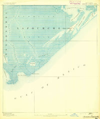
 1892 Creole1892 Print · USGSCoastal Lafourche and Jefferson parishes appear in the early 1890s as a complex of tidal wetlands and prairies. Genealogists and historians can trace the original watercourses of Bayou Lafourche, Little Lake, and the remote Shrimp Ids.4 unique versions available
 - 1892 Map of Pointe a La Hache, 1898 Print
 1892 Pointe a La Hache1898 Print · USGSThe lower Mississippi delta in the 1890s reveals a ribbon of riverfront settlements and competing rail lines. Genealogists and historians can trace family-named sites like Savoie and Nero or locate the Empire Mills (Martin) near Pt. A La Hache.
 - 1893 Map of Fort Livingston
 1893 Fort Livingston1893 Print · USGSThe Louisiana coast in the early 1890s is captured here as a sprawling network of tidal bayous and strategic passes. Local historians can trace maritime markers like Ft. Livingston and the Light on Grand Isle amid a maze of islands.3 unique versions available
End of results
Showing maps 1-10 of 10
Top cities of Jefferson Parish
- Metairie historical maps
- Kenner historical maps
- Gretna historical maps
- Waggaman historical maps
- Westwego historical maps
- Harahan historical maps
See more
Frequently asked questions
- What are the different types of historical maps available for Jefferson Parish?
- What is the oldest map of Jefferson Parish?
- Where can I purchase historical maps of Jefferson Parish for my home or office?
- Where can I download high-res historical maps of Jefferson Parish?
- Are there historical topographic maps available for Jefferson Parish?
- Is there historical aerial imagery available for Jefferson Parish?
- Where are historical maps of Jefferson Parish sourced from?