1940s Maps of Jefferson Parish, Louisiana
Explore 14 historic maps of Jefferson Parish from the 1940s. These maps offer a rare glimpse into what life looked like during the 1940s — showing old roads, neighborhoods, homes, and landmarks that have changed or disappeared over time.
Whether you're researching your family's past, planning a metal detecting trip, or studying how Jefferson Parish's landscape evolved across the 1940s, these high-resolution maps are a powerful tool for exploring the history of this region.
- Focus on a specific era: All maps on this page are from the 1940s, giving you a focused view of this time period.
- See what’s changed: Compare century-old streets, trails, and buildings to today's modern landscape using overlays and satellite layers.
- Research with precision: Use these maps for genealogy, historical research, land use analysis, or educational projects.
- View, download, or print: Maps are fully viewable online in high resolution, and can be downloaded or printed for your own records.
Start exploring Jefferson Parish's history through authentic maps from the 1940s. This is your window into the past.
Jefferson Parish, LA maps
(14)- 1940 Map of Bertrandville
 1940 Bertrandville1940 Print · USGSCoastal Louisiana at the start of the 1940s reveals a world of riverfront settlements and canal-driven industry. Genealogists and historians can trace the foundations of Bertrandville, locate St Johns Ch, and find long-standing landmarks like Woodlawn Sch along the Mississippi River.
 - 1941 Map of Barataria
 1941 Barataria1941 Print · USGSCoastal Jefferson Parish appears at the dawn of the 1940s, where the Mississippi River meets a vast network of bayous and wetlands. Genealogists can trace family roots in Barataria and Jesuit Bend, or locate historic local landmarks like Fisher Sch No 1 and the Lafitte P O.
 - 1942 Map of Lake Cataouatche East
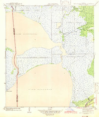 1942 Lake Cataouatche East1942 Print · USGSCoastal Jefferson and St. Charles Parishes are revealed in the early 1940s, documenting a landscape of expansive lakes and intricate bayous. Historians can trace early navigation routes through the Intracoastal Waterway and identify remote settlements like Bouquet des Chenes near Couba Island.
 - 1944 Map of Barataria
 1944 Barataria1944 Print · USGSCoastal Jefferson Parish appears as a intricate network of tidal bayous and marshes in the years during World War II. Genealogists and historians can trace the early settlement footprints of Lafitte P O, Villere, and the local Fisher Sch No 1.
 - 1944 Map of Pointe a La Hache
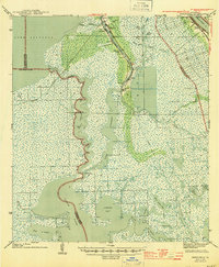
 1944 Pointe a La Hache1944 Print · USGSThe Mississippi River delta in the early 1940s shows a landscape of rail-connected river towns and vast marshlands. Trace family roots and local history through Deer Range Cem, St Jude Sch, and settlements like Pointe a la Hache.
 - 1945 Map of New Orleans
 1945 New Orleans1945 Print · USGSCoastal Louisiana and the Mississippi delta are captured here just after the war, showing the region's transition into a modern industrial and transit hub. Genealogists can trace family settlements along Bayou Teche or identify rail stops for the Illinois Central and Texas & Pacific lines.
 - 1947 Map of Bertrandville
 1947 Bertrandville1947 Print · USGSCoastal Louisiana at the edge of the Mississippi delta shows a landscape of river-bend settlements and deep-marsh waterways. Trace family roots and local history at Bertrandville, Crown Point, and Oakville, or locate the St Johns Ch and early schools.
 - 1947 Map of Caminada Pass
 1947 Caminada Pass1947 Print · USGSThe Louisiana coast at the end of the 1940s reveals a fragile world of barrier islands and marshlands along the Gulf. Researchers can trace the early path of State Highway No 620 across Cheniere Caminada and locate a local Cemetery near the shore.
 - 1947 Map of Wilkinson Bay
 1947 Wilkinson Bay1947 Print · USGSCoastal Plaquemines Parish in the late 1940s reveals a landscape of tidal marshes and isolated fishing outposts. Genealogists and historians can trace the early footprints of Manila Cabinash P O and Camp Dewey among waterways like Wilkinson Canal.
 - 1948 Map of Fort Livingston, 1950 Print
 1948 Fort Livingston1950 Print · USGSCoastal Plaquemines Parish in the late 1940s reveals a maritime landscape transitioning from fishing camps to industrial resource extraction. Researchers can trace the layout of Grand Isle and locate historic sites like Ft Livingston and the Barataria Lighthouse.
 - 1948 Map of Pointe a La Hache, 1951 Print
 1948 Pointe a La Hache1951 Print · USGSIn the late 1940s, the Mississippi River delta was a landscape of levee-side settlements and growing oil fields. Trace family history through riverfront outposts like Pointe a la Hache, the St Jude Sch (Colored) & Cem, and Beanbury Plantation.
 - 1949 Map of Bay Dosgris
 1949 Bay Dosgris1949 Print · USGSThe Jefferson and Lafourche Parish line runs through this coastal marshland during the late 1940s, showing a landscape of tidewater bays and bayous. Genealogists and researchers can locate the Alombro Cem and trace the original courses of Grand Bayou and Bayou St Denis.2 unique versions available
 - 1949 Map of Barataria Pass
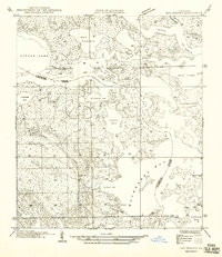
 1949 Barataria Pass1949 Print · USGSCoastal Jefferson Parish appears in this mid-century survey as a complex network of barrier islands and tidal passes. Researchers can trace the early footprint of Grand Isle and locate historical landmarks like Ft Livingston and the Barataria L. H.
 - 1949 Map of Bay Tambour
 1949 Bay Tambour1949 Print · USGSCoastal Louisiana at the end of the 1940s reveals a complex maze of bayous and salt marshes along the parish line. Genealogists and local historians can trace the original shoreline and named waterways like Bayou L'ours, Andre Island, and the Southwestern Louisiana Canal.2 unique versions available
End of results
Showing maps 1-14 of 14
Top cities of Jefferson Parish
- Metairie historical maps
- Kenner historical maps
- Gretna historical maps
- Waggaman historical maps
- Westwego historical maps
- Harahan historical maps
See more
Frequently asked questions
- What are the different types of historical maps available for Jefferson Parish?
- What is the oldest map of Jefferson Parish?
- Where can I purchase historical maps of Jefferson Parish for my home or office?
- Where can I download high-res historical maps of Jefferson Parish?
- Are there historical topographic maps available for Jefferson Parish?
- Is there historical aerial imagery available for Jefferson Parish?
- Where are historical maps of Jefferson Parish sourced from?