1970s Maps of Jefferson Parish, Louisiana
Explore 8 historic maps of Jefferson Parish from the 1970s. These maps offer a rare glimpse into what life looked like during the 1970s — showing old roads, neighborhoods, homes, and landmarks that have changed or disappeared over time.
Whether you're researching your family's past, planning a metal detecting trip, or studying how Jefferson Parish's landscape evolved across the 1970s, these high-resolution maps are a powerful tool for exploring the history of this region.
- Focus on a specific era: All maps on this page are from the 1970s, giving you a focused view of this time period.
- See what’s changed: Compare century-old streets, trails, and buildings to today's modern landscape using overlays and satellite layers.
- Research with precision: Use these maps for genealogy, historical research, land use analysis, or educational projects.
- View, download, or print: Maps are fully viewable online in high resolution, and can be downloaded or printed for your own records.
Start exploring Jefferson Parish's history through authentic maps from the 1970s. This is your window into the past.
Jefferson Parish, LA maps
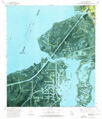
(8)- 1973 Map of Lake Laurier, 1976 Print
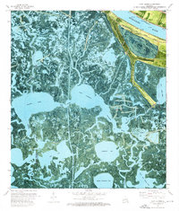 1973 Lake Laurier1976 Print · USGSThe Plaquemines Parish delta in the early 1970s reveals a landscape where river industry meets the deep marsh. Genealogists and historians can trace riverside settlements like Bellevue and Deer Range or locate the Deer Range Cem near the Mississippi River levee.2 unique versions available
 - 1973 Map of Wilkinson Bay, 1976 Print
 1973 Wilkinson Bay1976 Print · USGSThe coastal wetlands of Jefferson and Plaquemines Parishes are captured here in the early 1970s, showing a landscape defined by water and oil extraction. Trace the industrial development of the Manila Village Oil Field and the Barataria Waterway alongside coastal features like St Marys Point.2 unique versions available
 - 1973 Map of Grand Isle, 1976 Print
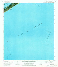 1973 Grand Isle1976 Print · USGSGrand Isle and the Jefferson Parish coast are captured here in the early seventies, a time when the energy industry transformed the shoreline. Maritime researchers can trace the Barataria Bay Waterway and offshore platforms in the Block 16 Oil and Gas Field.
 - 1973 Map of Barataria Pass, 1976 Print
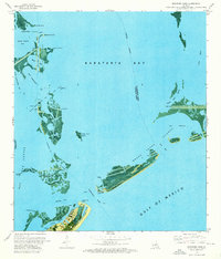 1973 Barataria Pass1976 Print · USGSCoastal Jefferson Parish in the early 1970s reveals a unique intersection of military history and the offshore energy industry. Researchers can locate the Ft Livingston Ruins, trace the developed waterfront of Grand Isle, and identify maritime landmarks like the Queen Bess Island Oil and Gas Field.2 unique versions available
 - 1973 Map of Barataria, 1976 Print
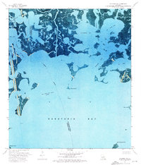
 1973 Barataria1976 Print · USGSCoastal Jefferson Parish in the early 1970s shows a landscape of traditional bayou life meeting heavy industry. Genealogists and historians can trace the community of Barataria near St Anthony Ch while mapping the vast reach of the South Barataria Oil and Gas Field.
 - 1973 Map of Lafitte, 1976 Print
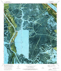 1973 Lafitte1976 Print · USGSCoastal Jefferson Parish in the early 1970s shows a landscape of traditional bayou settlements and rising industrial waterways. Genealogists can locate specific family burial grounds like Coulon Cem and Fisher Cem along the banks of Bayou Barataria.2 unique versions available
 - 1973 Map of Three Bayou Bay, 1976 Print
 1973 Three Bayou Bay1976 Print · USGSJefferson Parish marshlands are captured in the early seventies, showing a coastal landscape defined by the intersection of nature and industry. Researchers can trace the extensive energy infrastructure of the Barataria Oil and Gas Field, the Texaco Heliport, and the deep-water Barataria Bay Waterway.
 - 1973 Map of Bay L'ours, 1976 Print
 1973 Bay L'ours1976 Print · USGSThe marshy expanses of Jefferson and Lafourche Parishes are shown in the early seventies as a hub of coastal energy activity. Researchers can trace the layout of the Little Lake Oil and Gas Field and identify navigation points like Harvey Cutoff and Bayou Perot.
End of results
Showing maps 1-8 of 8
Top cities of Jefferson Parish
- Metairie historical maps
- Kenner historical maps
- Gretna historical maps
- Waggaman historical maps
- Westwego historical maps
- Harahan historical maps
See more
Frequently asked questions
- What are the different types of historical maps available for Jefferson Parish?
- What is the oldest map of Jefferson Parish?
- Where can I purchase historical maps of Jefferson Parish for my home or office?
- Where can I download high-res historical maps of Jefferson Parish?
- Are there historical topographic maps available for Jefferson Parish?
- Is there historical aerial imagery available for Jefferson Parish?
- Where are historical maps of Jefferson Parish sourced from?