1990s Maps of Kenner, Louisiana
Explore 8 historic maps of Kenner from the 1990s. These maps offer a rare glimpse into what life looked like during the 1990s — showing old roads, neighborhoods, homes, and landmarks that have changed or disappeared over time.
Whether you're researching your family's past, planning a metal detecting trip, or studying how Kenner's landscape evolved across the 1990s, these high-resolution maps are a powerful tool for exploring the history of this region.
- Focus on a specific era: All maps on this page are from the 1990s, giving you a focused view of this time period.
- See what’s changed: Compare century-old streets, trails, and buildings to today's modern landscape using overlays and satellite layers.
- Research with precision: Use these maps for genealogy, historical research, land use analysis, or educational projects.
- View, download, or print: Maps are fully viewable online in high resolution, and can be downloaded or printed for your own records.
Start exploring Kenner's history through authentic maps from the 1990s. This is your window into the past.
Kenner, LA maps
(8)- 1992 Map of Luling
 1992 Luling1992 Print · USGSSt. Charles Parish in the early nineties shows the dense riverfront settlements and industrial infrastructure lining the Mississippi. Researchers can locate the historic Davis Plantation, the site of the Davis Crevasse (1884), and St Charles Cem.
 - 1992 Map of New Orleans West
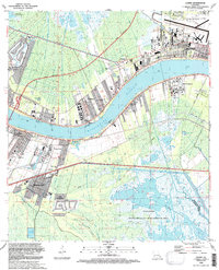
 1992 New Orleans West1992 Print · USGSGreater New Orleans is shown in high detail during the early nineties, centered on the river's sharp turns and industrial hubs. Genealogists and local historians can trace family roots through numerous parish schools and landmarks like Providence Memorial Park and the Huey P Long Bridge.2 unique versions available
 - 1992 Map of La Branche
 1992 La Branche1992 Print · USGSCoastal St. Charles Parish at the start of the nineties shows the meeting point of suburban Kenner and the vast Pontchartrain marshlands. Researchers can trace the development of Chateau Estates, locate the Jefferson Downs Racetrack, and see the extent of the East Good Hope Gas Field.
 - 1992 Map of Indian Beach
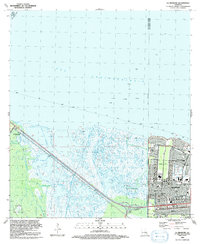
 1992 Indian Beach1992 Print · USGSThe Jefferson Parish shoreline in the early nineties shows the dense growth of suburban New Orleans behind a network of essential pumping stations and canals. Trace local landmarks from Jefferson Downs Racetrack to the older neighborhoods of Bucktown and Bonnabel Place.
 - 1998 Map of Luling, 2000 Print
 1998 Luling2000 Print · USGSSt. Charles Parish communities along the Mississippi River are shown here at the turn of the millennium. Researchers can trace land use from the Davis Plantation and Lone Star settlements to landmarks like the Davis Crevasse (1884).
 - 1998 Map of New Orleans West, 2000 Print
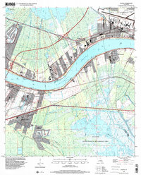
 1998 New Orleans West2000 Print · USGSJefferson Parish and the West Bank are shown in detail at the end of the millennium, as suburban growth met the industrial riverfront. Trace the intricate rail lines of the Illinois Central Gulf RR or locate family sites near Garden of Memories (Cem) and Lafreniere Park.
 - 1998 Map of Indian Beach, 2002 Print
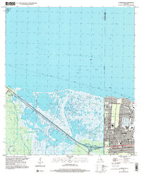
 1998 Indian Beach2002 Print · USGSJefferson Parish at the close of the nineties reveals a dense suburban landscape engineered against the waters of Lake Pontchartrain. Trace local landmarks like the Jefferson Downs Racetrack, the Lake Pontchartrain Causeway, and the neighborhood streets of Bucktown and Bissonet Plaza.
 - 1999 Map of La Branche, 2000 Print
 1999 La Branche2000 Print · USGSThe transition from the wild wetlands of St. Charles Parish to the suburban expansion of Kenner is captured here at the end of the millennium. Researchers can trace the development of Chateau Estates and find local landmarks like Seton Sch and the Jefferson Downs Racetrack.
End of results
Showing maps 1-8 of 8
Top cities near Kenner
- New Orleans historical maps
- Metairie historical maps
- Algiers historical maps
- Gretna historical maps
- Waggaman historical maps
- Westwego historical maps
See more
Top neighborhoods of Kenner
Frequently asked questions
- What are the different types of historical maps available for Kenner?
- What is the oldest map of Kenner?
- Where can I purchase historical maps of Kenner for my home or office?
- Where can I download high-res historical maps of Kenner?
- Are there historical topographic maps available for Kenner?
- Is there historical aerial imagery available for Kenner?
- Where are historical maps of Kenner sourced from?