1970s Maps of LaSalle Parish, Louisiana
Explore 4 historic maps of LaSalle Parish from the 1970s. These maps offer a rare glimpse into what life looked like during the 1970s — showing old roads, neighborhoods, homes, and landmarks that have changed or disappeared over time.
Whether you're researching your family's past, planning a metal detecting trip, or studying how LaSalle Parish's landscape evolved across the 1970s, these high-resolution maps are a powerful tool for exploring the history of this region.
- Focus on a specific era: All maps on this page are from the 1970s, giving you a focused view of this time period.
- See what’s changed: Compare century-old streets, trails, and buildings to today's modern landscape using overlays and satellite layers.
- Research with precision: Use these maps for genealogy, historical research, land use analysis, or educational projects.
- View, download, or print: Maps are fully viewable online in high resolution, and can be downloaded or printed for your own records.
Start exploring LaSalle Parish's history through authentic maps from the 1970s. This is your window into the past.
LaSalle Parish, LA maps
(4)- 1972 Map of Buckeye NE, 1974 Print
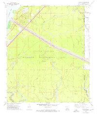 1972 Buckeye NE1974 Print · USGSLouisiana's deltaic wetlands are caught at a crossroads of conservation and industry in the early 1970s. Trace the complex waterworks of the Catahoula Lake Diversion Canal and locate historic drilling operations at the Cypress Bayou Oil Field.2 unique versions available
 - 1972 Map of Holloway, 1974 Print
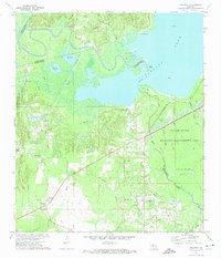 1972 Holloway1974 Print · USGSCentral Louisiana wetlands meet industrial expansion in the early 1970s as the Little River flows into the vast Catahoula Lake. Genealogists and local historians can trace the community of Holloway, locate Marthas Chapel, or follow the Old Railroad Grade through the bayous.3 unique versions available
 - 1972 Map of Green Gables, 1974 Print
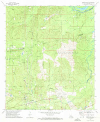 1972 Green Gables1974 Print · USGSRapides and Grant Parishes are captured in the early seventies, a landscape defined by the military grounds of Camp Beauregard and the Kisatchie National Forest. Researchers can trace the rural community of Green Gables, the airfield at ESLER FIELD, and local landmarks like Pheasant Grove Ch and Lofton Cem.2 unique versions available
 - 1972 Map of Powell Point, 1974 Print
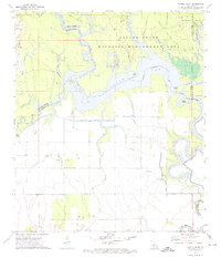 1972 Powell Point1974 Print · USGSLouisiana's river-and-bayou country is captured here in the early seventies, spanning four parish boundaries. Genealogists and historians can trace local landmarks like Deville Cem or explore the mid-century energy footprint of the Saline Lake Oil Field and West Saline Lake Oil Field.3 unique versions available
End of results
Showing maps 1-4 of 4
Top cities of LaSalle Parish
Frequently asked questions
- What are the different types of historical maps available for LaSalle Parish?
- What is the oldest map of LaSalle Parish?
- Where can I purchase historical maps of LaSalle Parish for my home or office?
- Where can I download high-res historical maps of LaSalle Parish?
- Are there historical topographic maps available for LaSalle Parish?
- Is there historical aerial imagery available for LaSalle Parish?
- Where are historical maps of LaSalle Parish sourced from?