1990s Maps of Pointe Coupee Parish, Louisiana
Explore 11 historic maps of Pointe Coupee Parish from the 1990s. These maps offer a rare glimpse into what life looked like during the 1990s — showing old roads, neighborhoods, homes, and landmarks that have changed or disappeared over time.
Whether you're researching your family's past, planning a metal detecting trip, or studying how Pointe Coupee Parish's landscape evolved across the 1990s, these high-resolution maps are a powerful tool for exploring the history of this region.
- Focus on a specific era: All maps on this page are from the 1990s, giving you a focused view of this time period.
- See what’s changed: Compare century-old streets, trails, and buildings to today's modern landscape using overlays and satellite layers.
- Research with precision: Use these maps for genealogy, historical research, land use analysis, or educational projects.
- View, download, or print: Maps are fully viewable online in high resolution, and can be downloaded or printed for your own records.
Start exploring Pointe Coupee Parish's history through authentic maps from the 1990s. This is your window into the past.
Pointe Coupee Parish, LA maps
(11)- 1991 Map of Woodville
 1991 Woodville1991 Print · USGSWilkinson County and the Louisiana borderlands appear here in the early nineties, where the bluffs meet the Mississippi River floodplain. Trace the sites of old river landings and rural outposts like Fort Adams, Pinckneyville, and the remote Larto Lake community.
 - 1992 Map of Grosse Tete
 1992 Grosse Tete1992 Print · USGSThe bayou country of Iberville Parish in the early 1990s reveals a landscape shaped by petroleum extraction and traditional settlements. Genealogists and researchers can trace local family landmarks like St Joseph Cem, Nativity Ch, and the hamlet of Slacks along the Bayou Grosse Tete.
 - 1992 Map of Maringouin
 1992 Maringouin1992 Print · USGSThe Atchafalaya Basin in the early nineties reveals a landscape split between the wild Atchafalaya National Wildlife Refuge and the industrial bayou towns. Researchers can trace family roots at New Zion Ch or explore the geography of the Maringouin Oil Field and the old Union Pacific line.
 - 1996 Map of Angola, 1998 Print
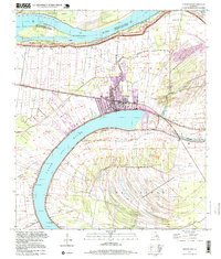
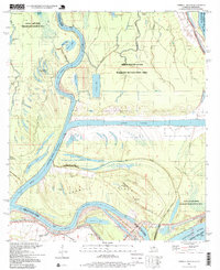
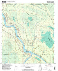
 1996 Angola1998 Print · USGSThe Mississippi River loop near the Louisiana-Mississippi border is captured here in the mid-1990s, highlighting the sprawling Louisiana State Penitentiary. Researchers can trace old river landings and rural landmarks like Como Landing, Clifford Cemetery, and the Old Railroad Grade.
 - 1996 Map of New Roads, 1999 Print
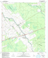
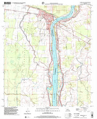
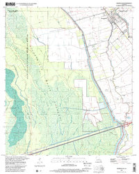
 1996 New Roads1999 Print · USGSPointe Coupee Parish in the mid-1990s shows a landscape shaped by the oxbow of the False River. Genealogists and historians can trace long-standing family land patterns in Jarreau and Parlange or locate landmarks like Zion Traveler Ch and Fairlane Cem.
 - 1996 Map of Turnbull Island, 1999 Print
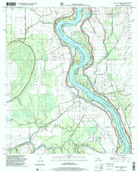
 1996 Turnbull Island1999 Print · USGSThe intricate waterways at the junction of the Mississippi and Red Rivers are captured here in the late twentieth century. Genealogists and historians can locate Oak Grove Ch, the Old Railroad Grade, and several cemeteries amidst the backwaters of Turnbull Island.
 - 1998 Map of Simmesport, 2002 Print
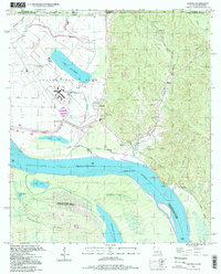
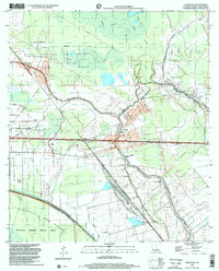
 1998 Simmesport2002 Print · USGSThe Atchafalaya River corridor at the close of the twentieth century reveals a landscape shaped by water and levee engineering. Genealogists and local historians can trace rural communities like Simmesport, Legonier, and Jacoby, along with landmarks like Dunbar High Sch and St Pauls Cem.
 - 1998 Map of Bayou Current, 2002 Print
 1998 Bayou Current2002 Print · USGSThe Atchafalaya River basin in the late 1990s shows a landscape of engineered floodways and persistent riverfront settlements. Researchers can locate numerous rural landmarks such as Indian Mound, Little Zion Ch, and the Morning Star Cem.
 - 1998 Map of Fordoche, 2002 Print
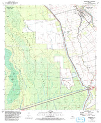
 1998 Fordoche2002 Print · USGSThe bayou country of Pointe Coupee Parish is shown here at the turn of the millennium, characterized by a complex network of oil fields and waterways. Researchers can locate community centers like Livonia and Fordoche, as well as the Valverda Sch and Sunlight Ch Cem.
 - 1999 Map of Maringouin NW, 2000 Print
 1999 Maringouin NW2000 Print · USGSThe Atchafalaya Basin at the close of the twentieth century reveals a landscape of industrial energy and protected wilderness. Researchers can trace the legacy of the Happytown Oil and Gas Field alongside the Atchafalaya River and Lake Comeaux.
 - 1999 Map of Maringouin, 2001 Print
 1999 Maringouin2001 Print · USGSIberville and Pointe Coupee parishes at the close of the century show a landscape defined by the Atchafalaya Basin Floodway and river commerce. Researchers can trace family sites at Shiloh Ch and West Oak Lane Cem or follow the UNION PACIFIC rail line through Musson.2 unique versions available
End of results
Showing maps 1-11 of 11
Top cities of Pointe Coupee Parish
Frequently asked questions
- What are the different types of historical maps available for Pointe Coupee Parish?
- What is the oldest map of Pointe Coupee Parish?
- Where can I purchase historical maps of Pointe Coupee Parish for my home or office?
- Where can I download high-res historical maps of Pointe Coupee Parish?
- Are there historical topographic maps available for Pointe Coupee Parish?
- Is there historical aerial imagery available for Pointe Coupee Parish?
- Where are historical maps of Pointe Coupee Parish sourced from?