1980s Maps of Pointe Coupee Parish, Louisiana
Explore 4 historic maps of Pointe Coupee Parish from the 1980s. These maps offer a rare glimpse into what life looked like during the 1980s — showing old roads, neighborhoods, homes, and landmarks that have changed or disappeared over time.
Whether you're researching your family's past, planning a metal detecting trip, or studying how Pointe Coupee Parish's landscape evolved across the 1980s, these high-resolution maps are a powerful tool for exploring the history of this region.
- Focus on a specific era: All maps on this page are from the 1980s, giving you a focused view of this time period.
- See what’s changed: Compare century-old streets, trails, and buildings to today's modern landscape using overlays and satellite layers.
- Research with precision: Use these maps for genealogy, historical research, land use analysis, or educational projects.
- View, download, or print: Maps are fully viewable online in high resolution, and can be downloaded or printed for your own records.
Start exploring Pointe Coupee Parish's history through authentic maps from the 1980s. This is your window into the past.
Pointe Coupee Parish, LA maps
(4)- 1982 Map of Big Bend
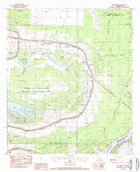 1982 Big Bend1982 Print · USGSAvoyelles Parish near the turn of the 1980s is captured here as a landscape of deep bayous and river floodways. Genealogists can locate family landmarks such as Old Morning Star Ch, Pilgrim Ch, and the winding banks of Bayou des Glaises.
 - 1983 Map of New Roads
 1983 New Roads1983 Print · USGSThe river parishes of central Louisiana are documented in the early 1980s, showcasing the winding courses of the Atchafalaya and Mississippi. Genealogists and historians can trace rail-served river towns like Melville and Simmesport, or locate the Port Hudson National Cem and the State Penitentiary.2 unique versions available
 - 1984 Map of Woodville
 1984 Woodville1984 Print · USGSThe Mississippi-Louisiana borderlands in the mid-eighties show a landscape defined by the shifting MISSISSIPPI RIVER and sprawling timberlands. Researchers can trace the ILLINOIS CENTRAL GULF railroad through Gloster or locate historic river points like Fort Adams and Point Breeze.
 - 1984 Map of Baton Rouge
 1984 Baton Rouge1984 Print · USGSBaton Rouge and the surrounding river country are captured in the mid-eighties as the industrial corridor met the deep wetlands of the basin. Researchers can trace the winding Bayou Teche, locate family roots in St Martinville, or study the massive Atchafalaya Basin Floodway.2 unique versions available
End of results
Showing maps 1-4 of 4
Top cities of Pointe Coupee Parish
Frequently asked questions
- What are the different types of historical maps available for Pointe Coupee Parish?
- What is the oldest map of Pointe Coupee Parish?
- Where can I purchase historical maps of Pointe Coupee Parish for my home or office?
- Where can I download high-res historical maps of Pointe Coupee Parish?
- Are there historical topographic maps available for Pointe Coupee Parish?
- Is there historical aerial imagery available for Pointe Coupee Parish?
- Where are historical maps of Pointe Coupee Parish sourced from?