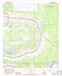
1982 Map of Big Bend
USGS Topo · Published 1982About this map
Bayou des Glaises snakes through this landscape, defining the settlement patterns of Big Bend and the surrounding river country. The community is marked by a series of local landmarks including Antioch Ch, St Michaels Ch, and Bayou des Glaises Ch, which cluster along the high ground near the water's edge. To the south, the massive West Atchafalaya Floodway dominates the geography, a critical piece of infrastructure designed to manage the volatile waters of the Atchafalaya River.
Find a feature on this map
40 named features on this map. Tap any name to fly to it.
Don’t see what you’re looking for? This feature index may not catch every label — zoom into the map to look around manually.
Map Details
Editions of this 1982 Big Bend Map
This is the sole edition of this map. No revisions or reprints were ever made.
Other maps of this area

1939 · Artonish
USGS Topo · 1:62,500

1941 · Voorhies
USGS Topo · 1:62,500

1941 · Batchelor
USGS Topo · 1:62,500

1953 · Natchez
USGS Topo · 1:250,000

1954 · Artonish
USGS Topo · 1:62,500

1954 · Baton Rouge
USGS Topo · 1:250,000

1955 · Artonish
USGS Topo · 1:62,500

1955 · Batchelor
USGS Topo · 1:62,500

1955 · Odenburg
USGS Topo · 1:62,500

1956 · Natchez
USGS Topo · 1:250,000