1940s Maps of Pointe Coupee Parish, Louisiana
Explore 4 historic maps of Pointe Coupee Parish from the 1940s. These maps offer a rare glimpse into what life looked like during the 1940s — showing old roads, neighborhoods, homes, and landmarks that have changed or disappeared over time.
Whether you're researching your family's past, planning a metal detecting trip, or studying how Pointe Coupee Parish's landscape evolved across the 1940s, these high-resolution maps are a powerful tool for exploring the history of this region.
- Focus on a specific era: All maps on this page are from the 1940s, giving you a focused view of this time period.
- See what’s changed: Compare century-old streets, trails, and buildings to today's modern landscape using overlays and satellite layers.
- Research with precision: Use these maps for genealogy, historical research, land use analysis, or educational projects.
- View, download, or print: Maps are fully viewable online in high resolution, and can be downloaded or printed for your own records.
Start exploring Pointe Coupee Parish's history through authentic maps from the 1940s. This is your window into the past.
Pointe Coupee Parish, LA maps
(4)- 1940 Map of Grosse Tete, 1950 Print
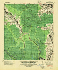 1940 Grosse Tete1950 Print · USGSThe Louisiana river parishes are shown just before the mid-century, defined by a complex network of bayous and sprawling plantation estates. Genealogists and historians can trace family-named sites like Shady Grove Plantation, United Reformers Ch & Sch, and the Texas and Pacific RR corridor.
 - 1940 Map of Arnaudville, 1964 Print
 1940 Arnaudville1964 Print · USGSThe Cajun heartland of the 1940s is detailed here as it manages its complex relationship with the Atchafalaya. Genealogists can trace family names through landmarks like Le Bourgeois Plantation, Magenta Plantation, and the St Elizabeth Ch & Sch.
 - 1941 Map of Voorhies, 1943 Print
 1941 Voorhies1943 Print · USGSAvoyelles Parish is captured here in the early 1940s, showcasing a river-bound landscape shaped by the Red River and its many oxbows. Genealogists can trace family roots through numerous landmarks like St James Ch & Cem, Voorhies School, and Moreauville.2 unique versions available
 - 1941 Map of Batchelor, 1944 Print
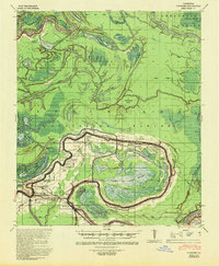
 1941 Batchelor1944 Print · USGSThe Mississippi River's powerful shifts define this corner of Louisiana in the early 1940s, from the oxbows of the Raccourci Old River to the banks of Angola. Local researchers can locate family landmarks such as Mains Plantation, St Stevens Ch, and the Lower Latanache Sch.
End of results
Showing maps 1-4 of 4
Top cities of Pointe Coupee Parish
Frequently asked questions
- What are the different types of historical maps available for Pointe Coupee Parish?
- What is the oldest map of Pointe Coupee Parish?
- Where can I purchase historical maps of Pointe Coupee Parish for my home or office?
- Where can I download high-res historical maps of Pointe Coupee Parish?
- Are there historical topographic maps available for Pointe Coupee Parish?
- Is there historical aerial imagery available for Pointe Coupee Parish?
- Where are historical maps of Pointe Coupee Parish sourced from?