1930s Maps of Pointe Coupee Parish, Louisiana
Explore 4 historic maps of Pointe Coupee Parish from the 1930s. These maps offer a rare glimpse into what life looked like during the 1930s — showing old roads, neighborhoods, homes, and landmarks that have changed or disappeared over time.
Whether you're researching your family's past, planning a metal detecting trip, or studying how Pointe Coupee Parish's landscape evolved across the 1930s, these high-resolution maps are a powerful tool for exploring the history of this region.
- Focus on a specific era: All maps on this page are from the 1930s, giving you a focused view of this time period.
- See what’s changed: Compare century-old streets, trails, and buildings to today's modern landscape using overlays and satellite layers.
- Research with precision: Use these maps for genealogy, historical research, land use analysis, or educational projects.
- View, download, or print: Maps are fully viewable online in high resolution, and can be downloaded or printed for your own records.
Start exploring Pointe Coupee Parish's history through authentic maps from the 1930s. This is your window into the past.
Pointe Coupee Parish, LA maps
(4)- 1935 Map of Osca Bayou, 1938 Print
 1935 Osca Bayou1938 Print · USGSThe Atchafalaya Basin in the mid-1930s is a complex web of wetlands and early river engineering projects. Researchers can trace historic family locations and transit routes near Maringouin, Butte La Rose, and the St Joseph Ch & Cem.
 - 1939 Map of St. Francisville
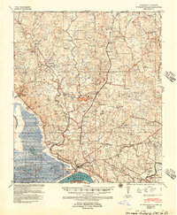 1939 St. Francisville1939 Print · USGSWest Feliciana Parish and the Mississippi River borderlands are captured here in the late 1930s. Genealogists and historians can trace the foundations of the plantation economy through landmarks like Magnolia Plantation and schools like Afton Villa Ch & Sch.3 unique versions available
 - 1939 Map of Artonish, 1945 Print
 1939 Artonish1945 Print · USGSThe river-and-rail economy of the Louisiana-Mississippi border is frozen in time just before the mid-century, showing the dense settlement of the bottomlands. Genealogists can trace family roots through numerous local landmarks like Fort Adams, Singleton Chapel & Cem, and the Black Hawk Plantation.
 - 1939 Map of Fordoche, 1948 Print
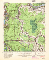 1939 Fordoche1948 Print · USGSThe rail-and-river corridor of Pointe Coupee Parish comes alive in this late 1930s survey, showing the land just as new flood controls were being established. Researchers can trace family history through rural community anchors like Sunlight Ch & Cem, Lottie, and Elliot City.2 unique versions available
End of results
Showing maps 1-4 of 4
Top cities of Pointe Coupee Parish
Frequently asked questions
- What are the different types of historical maps available for Pointe Coupee Parish?
- What is the oldest map of Pointe Coupee Parish?
- Where can I purchase historical maps of Pointe Coupee Parish for my home or office?
- Where can I download high-res historical maps of Pointe Coupee Parish?
- Are there historical topographic maps available for Pointe Coupee Parish?
- Is there historical aerial imagery available for Pointe Coupee Parish?
- Where are historical maps of Pointe Coupee Parish sourced from?