1930s Maps of Red River Parish, Louisiana
Explore 4 historic maps of Red River Parish from the 1930s. These maps offer a rare glimpse into what life looked like during the 1930s — showing old roads, neighborhoods, homes, and landmarks that have changed or disappeared over time.
Whether you're researching your family's past, planning a metal detecting trip, or studying how Red River Parish's landscape evolved across the 1930s, these high-resolution maps are a powerful tool for exploring the history of this region.
- Focus on a specific era: All maps on this page are from the 1930s, giving you a focused view of this time period.
- See what’s changed: Compare century-old streets, trails, and buildings to today's modern landscape using overlays and satellite layers.
- Research with precision: Use these maps for genealogy, historical research, land use analysis, or educational projects.
- View, download, or print: Maps are fully viewable online in high resolution, and can be downloaded or printed for your own records.
Start exploring Red River Parish's history through authentic maps from the 1930s. This is your window into the past.
Red River Parish, LA maps
(4)- 1937 Map of Campti NE
 1937 Campti NE1937 Print · USGSNatchitoches Parish at the end of the 1930s was a landscape of intricate bayous and timber tracts. Researchers can trace the path of the Logging Railroad or find family landmarks like Mt Zion Ch and the Clear Lake Sch near Campti.
 - 1937 Map of Campti NW
 1937 Campti NW1937 Print · USGSNatchitoches and Red River Parishes in the late thirties show a river-driven landscape of small farmsteads and rural schools. Genealogists and local historians can locate family sites like Sims Cem and old schoolhouses including Zion Hill Sch or New Manuel Sch.
 - 1938 Map of Chemard Lake
 1938 Chemard Lake1938 Print · USGSIn the late 1930s, the De Soto Parish riverlands were a complex world of winding bayous and small rural schoolhouses. Genealogists and historians can trace the foundations of local life at Rambin Store, Ajax, and country schools like Egypt Sch and Summer Hill Sch.
 - 1938 Map of Lake End
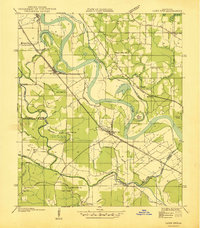 1938 Lake End1938 Print · USGSThe Red River valley comes alive in the late 1930s, showing the intersection of three Louisiana parishes and their vital rail corridors. Genealogists and historians can trace community life through old landmarks like Logan Chapel, Ajax Church, and the riverfront settlement of Lake End.
End of results
Showing maps 1-4 of 4
Top cities of Red River Parish
Frequently asked questions
- What are the different types of historical maps available for Red River Parish?
- What is the oldest map of Red River Parish?
- Where can I purchase historical maps of Red River Parish for my home or office?
- Where can I download high-res historical maps of Red River Parish?
- Are there historical topographic maps available for Red River Parish?
- Is there historical aerial imagery available for Red River Parish?
- Where are historical maps of Red River Parish sourced from?