1970s Maps of Red River Parish, Louisiana
Explore 2 historic maps of Red River Parish from the 1970s. These maps offer a rare glimpse into what life looked like during the 1970s — showing old roads, neighborhoods, homes, and landmarks that have changed or disappeared over time.
Whether you're researching your family's past, planning a metal detecting trip, or studying how Red River Parish's landscape evolved across the 1970s, these high-resolution maps are a powerful tool for exploring the history of this region.
- Focus on a specific era: All maps on this page are from the 1970s, giving you a focused view of this time period.
- See what’s changed: Compare century-old streets, trails, and buildings to today's modern landscape using overlays and satellite layers.
- Research with precision: Use these maps for genealogy, historical research, land use analysis, or educational projects.
- View, download, or print: Maps are fully viewable online in high resolution, and can be downloaded or printed for your own records.
Start exploring Red River Parish's history through authentic maps from the 1970s. This is your window into the past.
Red River Parish, LA maps
(2)- 1979 Map of East Point, 1980 Print
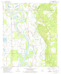 1979 East Point1980 Print · USGSRed River Parish in the late seventies is defined by the winding Red River and the rural communities clustered along its fertile banks. Genealogists and local historians can locate several country churches and cemeteries, including St Marks Cem, True Vine Ch, and the community of East Point.
 - 1979 Map of Coushatta, 1980 Print
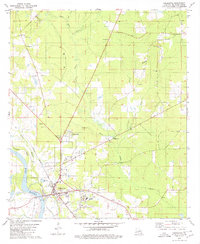 1979 Coushatta1980 Print · USGSThe Red River valley in the late seventies reveals a landscape of petroleum exploration and riverside commerce. Trace family roots at Carroll Creek Ch Cem and follow the Kansas City Southern rail line through Coushatta.
End of results
Showing maps 1-2 of 2
Top cities of Red River Parish
Frequently asked questions
- What are the different types of historical maps available for Red River Parish?
- What is the oldest map of Red River Parish?
- Where can I purchase historical maps of Red River Parish for my home or office?
- Where can I download high-res historical maps of Red River Parish?
- Are there historical topographic maps available for Red River Parish?
- Is there historical aerial imagery available for Red River Parish?
- Where are historical maps of Red River Parish sourced from?