1940s Maps of Red River Parish, Louisiana
Explore 8 historic maps of Red River Parish from the 1940s. These maps offer a rare glimpse into what life looked like during the 1940s — showing old roads, neighborhoods, homes, and landmarks that have changed or disappeared over time.
Whether you're researching your family's past, planning a metal detecting trip, or studying how Red River Parish's landscape evolved across the 1940s, these high-resolution maps are a powerful tool for exploring the history of this region.
- Focus on a specific era: All maps on this page are from the 1940s, giving you a focused view of this time period.
- See what’s changed: Compare century-old streets, trails, and buildings to today's modern landscape using overlays and satellite layers.
- Research with precision: Use these maps for genealogy, historical research, land use analysis, or educational projects.
- View, download, or print: Maps are fully viewable online in high resolution, and can be downloaded or printed for your own records.
Start exploring Red River Parish's history through authentic maps from the 1940s. This is your window into the past.
Red River Parish, LA maps
(8)- 1941 Map of East Point
 1941 East Point1941 Print · USGSThe Red River Valley bottomlands are captured here in the late 1930s, showing a network of riverfront settlements and rural parish life. Researchers can trace family history through numerous landmarks like Elizabeth Church, Crichton School, and the St Marks Cemetery near the Bayou Toulon.
 - 1944 Map of Campti, 1955 Print
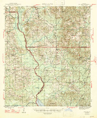
 1944 Campti1955 Print · USGSNatchitoches and the Red River valley are shown here during the mid-1940s, highlighting a landscape of river bends and rail-dependent settlements. Researchers can trace family roots through numerous country landmarks like Bethlehem Sch, St Lukes Cem, and the river port at Grand Ecore.
 - 1945 Map of Mansfield, 1956 Print
 1945 Mansfield1956 Print · USGSDe Soto Parish in the mid-1940s centers on the rail junction at Mansfield just as the local landscape transitioned toward the post-war era. Genealogists can locate family sites at Evergreen Cem, Rock Chapel, and the historic Mansfield Battle Memorial Park.
 - 1947 Map of Ashland
 1947 Ashland1947 Print · USGSNorth Louisiana's parish boundaries converge in this mid-century landscape where timber and rail lines defined daily life. Genealogists can locate numerous rural landmarks like St Mathews Ch, Old Saline Cem, and the old rail stop at Ashland.
 - 1947 Map of Mansfield
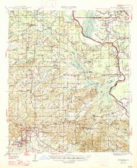 1947 Mansfield1947 Print · USGSIn the late 1940s, the De Soto Parish landscape centered on the rail hub of Mansfield and its surrounding plantation lands. Genealogists can trace family roots through numerous rural landmarks like the Lands End Plantation, Rock Chapel, and the Evergreen Cem.
 - 1947 Map of Hanna
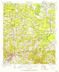
 1947 Hanna1947 Print · USGSRed River Parish and Natchitoches Parish are shown in the late 1940s, a period when the river valley remained a landscape of ferries, rural schools, and bayous. Genealogists can trace family landmarks like the Rambin Store, Jordon Ferry, and St James Cem.
 - 1948 Map of Coushatta
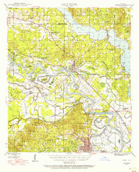
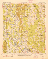 1948 Coushatta1948 Print · USGSRed River Parish and the surrounding hill country are captured here just after the war, showing the intricate river-and-rail network. Genealogists can trace family names through dozens of landmarks like Elizabeth Sch, St Pauls Cem, and Hall Summit.
 - 1948 Map of Campti
 1948 Campti1948 Print · USGSNatchitoches Parish and the Red River valley are captured in the late 1940s, showing a landscape defined by oxbows and rural life. Researchers can trace historic schools and churches from Campti to Powhatan, including Bethel Cem and Grappes Bluff.2 unique versions available
End of results
Showing maps 1-8 of 8
Top cities of Red River Parish
Frequently asked questions
- What are the different types of historical maps available for Red River Parish?
- What is the oldest map of Red River Parish?
- Where can I purchase historical maps of Red River Parish for my home or office?
- Where can I download high-res historical maps of Red River Parish?
- Are there historical topographic maps available for Red River Parish?
- Is there historical aerial imagery available for Red River Parish?
- Where are historical maps of Red River Parish sourced from?