Old Maps of Avalon Terrace, Louisiana for Genealogy
Trace your family roots with 16 historic maps of Avalon Terrace. These high-res maps reveal old neighborhoods, homesites, landmarks, and streets — helping you uncover where your ancestors lived and how the area evolved over time.
- Explore historic neighborhoods: Identify where your relatives may have lived in the 1800s or 1900s.
- Compare maps over time: Trace the changes in streets, buildings, and landmarks for multi-generational research.
- Perfect for genealogy & ancestry research: Used by family historians and researchers to map out lineage and migration.
These maps are an incredible resource for exploring your personal connection to Avalon Terrace's past.
Avalon Terrace, LA maps
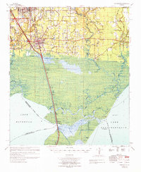
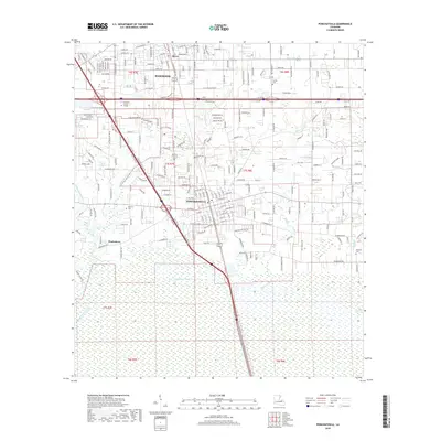
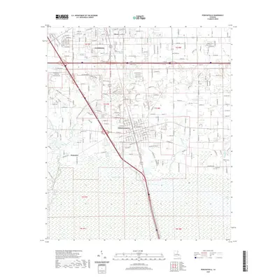
(16)- 1935 Map of Ponchatoula
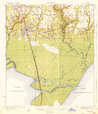 1935 Ponchatoula1935 Print · USGSCoastal Tangipahoa Parish is seen here in the mid-1930s, where the railroad and early highways began to bridge the gap between the piney woods and the great lakes. Researchers can locate family landmarks like Mitchell Cemetery or trace the old routes to the Manchac Akers Post Office and Jones Island.2 unique versions available
 - 1939 Map of Ponchatoula
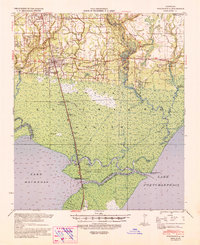 1939 Ponchatoula1939 Print · USGSLouisiana's Florida Parishes are captured here in the late thirties, where the rail lines of the Illinois Central meet the cypress swamps. Researchers can trace family roots at Wetmore Cem or locate the remote Pass Manchac LH and the lumber camps of the Louisiana Cypress Lumber Co.
 - 1951 Map of Ponchatoula, 1953 Print
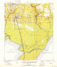 1951 Ponchatoula1953 Print · USGSThe swampy interface of Tangipahoa Parish is captured in the early fifties as the railroad reached across the wetlands toward New Orleans. Trace historical footprints at Manchac Akers P.O., find family sites like Edwards Cem, or locate the Pass Manchac L H.3 unique versions available
 - 1954 Map of Baton Rouge, 1974 Print
 1954 Baton Rouge1974 Print · USGSSoutheast Louisiana in the mid-fifties is captured here during a period of transition for its river and rail economies. Researchers can trace the path of the Mississippi River and find landmarks like the Bonnet Carre Spillway and Bayou Plaquemine.2 unique versions available
 - 1956 Map of Baton Rouge
 1956 Baton Rouge1956 Print · USGSSouth Louisiana at the height of the mid-century oil boom shows a landscape of river oxbows and rising industry. Researchers can trace family roots through river towns like Scotlandville or locate early industrial sites and Oil wells near Lake Maurepas.
 - 1961 Map of Baton Rouge, 1966 Print
 1961 Baton Rouge1966 Print · USGSSoutheastern Louisiana in the early sixties remains a landscape of deep river bends and sprawling coastal lakes. Genealogists and historians can trace the rail-and-river economy through landmarks like Free-Nigger Point, Donaldsonville, and the Illinois Central Railroad.
 - 1962 Map of Baton Rouge
 1962 Baton Rouge1962 Print · USGSSouth Louisiana in the early sixties reveals a landscape of river-bend parishes and emerging interstate corridors. Genealogists and historians can trace family roots through historic river towns like Donaldsonville and Plaquemine, or follow the path of the Illinois Central Railroad through the swamp basins.
 - 1968 Map of Ponchatoula, 1969 Print
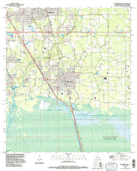
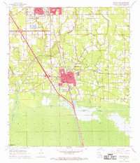 1968 Ponchatoula1969 Print · USGSTangipahoa Parish at the end of the sixties shows the steady growth of Ponchatoula and Hammond alongside the vital Illinois Central corridor. Genealogists can locate family landmarks such as Wetmore Cem, Mitchell Cem, and the French Corner Ch.3 unique versions available
 - 1969 Map of Ponchatoula, 1971 Print
 1969 Ponchatoula1971 Print · USGSThe Florida Parishes meet the marshlands of the Lake Pontchartrain basin in the late sixties. Genealogists and historians can trace family-named sites like Arnold Cem, Lees Landing, and the Champ Cooper Sch near the ILLINOIS CENTRAL line.
 - 1983 Map of Ponchatoula, 1984 Print
 1983 Ponchatoula1984 Print · USGSThe Lake Pontchartrain Basin and the River Parishes come into focus during the early 1980s, showcasing the region's complex water-dependent geography. Researchers can trace the rail routes of the Illinois Central Gulf Railroad and explore landmarks from Pass Manchac to Donaldsonville.2 unique versions available
 - 1994 Map of Ponchatoula, 1996 Print
 1994 Ponchatoula1996 Print · USGSThe Strawberry Capital of the World and the surrounding Tangipahoa Parish wetlands are captured here in the mid-nineties. Trace family roots at Arnold Cem or Mitchell Cem, and explore the reach of the Joyce State Wildlife Management Area.
 - 2012 Map of Ponchatoula, 2012 Print
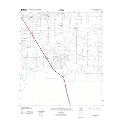 2012 Ponchatoula2012 Print · USGSCovers Avalon Terrace, including Hammond, Ponchatoula, and other nearby areas
 - 2015 Map of Ponchatoula, 2015 Print
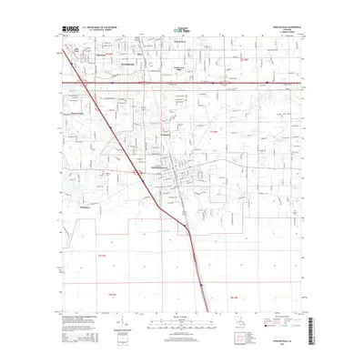 2015 Ponchatoula2015 Print · USGSCovers Avalon Terrace, including Hammond, Ponchatoula, and other nearby areas
 - 2018 Map of Ponchatoula, 2018 Print
 2018 Ponchatoula2018 Print · USGSCovers Avalon Terrace, including Hammond, Ponchatoula, and other nearby areas
 - 2020 Map of Ponchatoula, 2020 Print
 2020 Ponchatoula2020 Print · USGSCovers Avalon Terrace, including Hammond, Ponchatoula, and other nearby areas
 - 2024 Map of Ponchatoula, 2024 Print
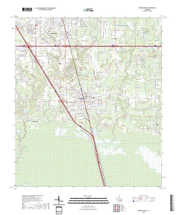 2024 Ponchatoula2024 Print · USGSThe Strawberry Capital of the World and its surrounding wetlands are captured here in the contemporary era. Genealogists and local historians can trace the town layouts and find family markers at Ponchatoula Cem, Charbonnet Cem, and the quiet settlement of Wadesboro.
End of results
Showing maps 1-16 of 16
Top cities near Avalon Terrace
- Hammond historical maps
- Ponchatoula historical maps
- Independence historical maps
- Killian historical maps
- Albany historical maps
- Folsom historical maps
See more
Frequently asked questions
- What are the different types of historical maps available for Avalon Terrace?
- What is the oldest map of Avalon Terrace?
- Where can I purchase historical maps of Avalon Terrace for my home or office?
- Where can I download high-res historical maps of Avalon Terrace?
- Are there historical topographic maps available for Avalon Terrace?
- Is there historical aerial imagery available for Avalon Terrace?
- Where are historical maps of Avalon Terrace sourced from?