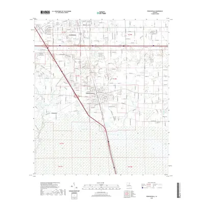
2020 Map of Ponchatoula
USGS Topo · Published 2020About this map
Ponchatoula and Hammond anchor this modern survey of Tangipahoa Parish, where the developed street grids of these historic railroad towns meet the extensive wetlands of southern Louisiana. The landscape transitions from the urban centers through smaller settlements like Wadesboro and Oliver into the broad expanse of Four Mile Marsh. Waterways such as Ponchatoula Creek and the Yellow Water River define the local drainage patterns, while the Anderson Canal cuts a straight path through the low-lying terrain to the south. Genealogists will find several burial grounds across the quadrangle, including Wetmore Cem, Holly Gardens Cem, and Charbonnet Cem. The map illustrates the contemporary infrastructure of the region, showing the density of residential growth in Mendoza Hts and the complex interchange of I-12 near S I-12 Svc Rd, reflecting decades of transit-driven development in the Florida Parishes.
Find a feature on this map
105 named features on this map. Tap any name to fly to it.
Don’t see what you’re looking for? This feature index may not catch every label — zoom into the map to look around manually.
Map Details
Editions of this 2020 Ponchatoula Map
This is the sole edition of this map. No revisions or reprints were ever made.
Other maps of this area

1934 · Springfield
USGS Topo · 1:62,500

1935 · Ponchatoula
USGS Topo · 1:62,500

1939 · Ponchatoula
USGS Topo · 1:62,500

1939 · Springfield
USGS Topo · 1:62,500

1940 · Tickfaw
USGS Topo · 1:31,680

1942 · Robert
USGS Topo · 1:31,680

1949 · Albany
USGS Topo · 1:31,680

1951 · Ponchatoula
USGS Topo · 1:62,500

1954 · Baton Rouge
USGS Topo · 1:250,000

1956 · Baton Rouge
USGS Topo · 1:250,000