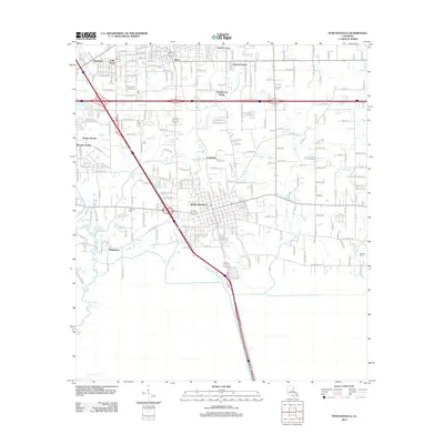
2012 Map of Ponchatoula
USGS Topo · Published 2012About this map
Ponchatoula serves as the central hub of this 2012 survey, where the intersection of I-55 and State Route 22 shapes the modern landscape of Tangipahoa Parish. The map reveals a transition from dense residential clusters like Southwood Ridge and Cypress Cove in the north to the more scattered settlement of Wadesboro toward the southwest. Water defines the boundaries of development here, with Ponchatoula Cr and Selsers Cr winding through the eastern reaches. Local history and genealogy interest is anchored by several burial sites, including Wetmore Cem near the town center and Arnold Cem to the northeast. The presence of Hoovers Pond and the complex waterways of the S Slough illustrate the low-lying, hydrologically active nature of this coastal Louisiana region, where drainage patterns have historically dictated the placement of roads and homesteads.
Find a feature on this map
21 named features on this map. Tap any name to fly to it.
Don’t see what you’re looking for? This feature index may not catch every label — zoom into the map to look around manually.
Map Details
Editions of this 2012 Ponchatoula Map
This is the sole edition of this map. No revisions or reprints were ever made.
Other maps of this area

1934 · Springfield
USGS Topo · 1:62,500

1935 · Ponchatoula
USGS Topo · 1:62,500

1939 · Ponchatoula
USGS Topo · 1:62,500

1939 · Springfield
USGS Topo · 1:62,500

1940 · Tickfaw
USGS Topo · 1:31,680

1942 · Robert
USGS Topo · 1:31,680

1949 · Albany
USGS Topo · 1:31,680

1951 · Ponchatoula
USGS Topo · 1:62,500

1954 · Baton Rouge
USGS Topo · 1:250,000

1956 · Baton Rouge
USGS Topo · 1:250,000