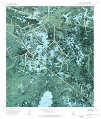
1970s Maps of Terrebonne Parish, Louisiana
Explore 8 historic maps of Terrebonne Parish from the 1970s. These maps offer a rare glimpse into what life looked like during the 1970s — showing old roads, neighborhoods, homes, and landmarks that have changed or disappeared over time.
Whether you're researching your family's past, planning a metal detecting trip, or studying how Terrebonne Parish's landscape evolved across the 1970s, these high-resolution maps are a powerful tool for exploring the history of this region.
- Focus on a specific era: All maps on this page are from the 1970s, giving you a focused view of this time period.
- See what’s changed: Compare century-old streets, trails, and buildings to today's modern landscape using overlays and satellite layers.
- Research with precision: Use these maps for genealogy, historical research, land use analysis, or educational projects.
- View, download, or print: Maps are fully viewable online in high resolution, and can be downloaded or printed for your own records.
Start exploring Terrebonne Parish's history through authentic maps from the 1970s. This is your window into the past.
Terrebonne Parish, LA maps
(8)- 1970 Map of Point Au Fer NE, 1971 Print
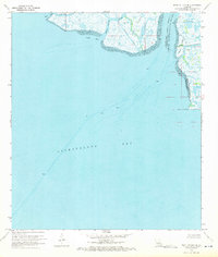 1970 Point Au Fer NE1971 Print · USGSThe Louisiana coast at the mouth of the Atchafalaya was a frontier of energy exploration and maritime transit during the early seventies. Researchers can trace the shifting parish lines and locate offshore infrastructure like Drill Holes near Shell Island and Plumb Island Point.3 unique versions available
 - 1970 Map of Point Au Fer, 1971 Print
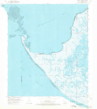 1970 Point Au Fer1971 Print · USGSCoastal Terrebonne Parish in the early seventies reveals a landscape of industrial expansion amidst the marshes. Trace the development of the Locust Bayou Oil Field and locate remote coastal landmarks like Eugene Island and Dead Alligator Point.3 unique versions available
 - 1974 Map of Lost Lake, 1976 Print
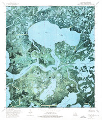 1974 Lost Lake1976 Print · USGSCoastal Terrebonne Parish appears here in the mid-seventies as a shifting landscape of tidal marsh and bayous. Researchers can trace the waterway connections of Lost Lake, Rice Island, and industrial markers like the Gas Wells and pipelines.3 unique versions available
 - 1974 Map of Plumb Bayou, 1976 Print
 1974 Plumb Bayou1976 Print · USGSThe Louisiana coast in the mid-seventies reveals a dense network of energy infrastructure carved into the Terrebonne Parish wetlands. Trace the intersection of industry and water at Halters Island and the sprawling West Deer Island Oil Field.2 unique versions available
 - 1974 Map of Fourleague Bay, 1976 Print
 1974 Fourleague Bay1976 Print · USGSCoastal Louisiana at the height of the offshore energy boom is captured here, showing the intricate marshlands and bayous of Terrebonne Parish. Researchers can trace historical shoreline positions and navigate the waters around Point Au Fer Island, Mosquito Pass, and the Mosquito Bay Gas Field.
 - 1974 Map of Carencro Bayou, 1976 Print
 1974 Carencro Bayou1976 Print · USGSCoastal Louisiana in the mid-seventies is revealed here as an intricate web of industrial infrastructure and tidal waterways. Researchers can trace energy operations through an Oil Field and Pipelines or locate landmarks like Hebert Island and Camp 2.2 unique versions available
 - 1974 Map of East Bay Junop, 1976 Print
 1974 East Bay Junop1976 Print · USGSCoastal Terrebonne Parish appears as a complex web of wetlands and tidal channels in the mid-1970s, just as offshore energy infrastructure expanded. Researchers can trace historic waterways like Hellhole Bay and Pelican Pass or locate early industrial sites marked by a Pipeline and scattered Drill Holes.
 - 1974 Map of Oyster Bayou, 1976 Print
 1974 Oyster Bayou1976 Print · USGSThe Louisiana coast near Terrebonne Parish is captured here during the mid-seventies, showing the transition between coastal marsh and offshore industry. Researchers can trace the maritime footprint of Oyster and the Oyster Bayou Lighthouse alongside an expansive Oil Field.
End of results
Showing maps 1-8 of 8
Top cities of Terrebonne Parish
Frequently asked questions
- What are the different types of historical maps available for Terrebonne Parish?
- What is the oldest map of Terrebonne Parish?
- Where can I purchase historical maps of Terrebonne Parish for my home or office?
- Where can I download high-res historical maps of Terrebonne Parish?
- Are there historical topographic maps available for Terrebonne Parish?
- Is there historical aerial imagery available for Terrebonne Parish?
- Where are historical maps of Terrebonne Parish sourced from?