Old Maps of Terrebonne Parish, Louisiana for Hiking & Exploration
Hike through history with 375 historic maps of Terrebonne Parish. Explore old trails, ghost towns, and forgotten backroads — perfect for outdoor adventurers and local explorers.
- Rediscover forgotten places: Map out old mining camps, roads, and footpaths that no longer exist on modern maps.
- Layer with modern tools: Combine with LiDAR or satellite views to plan hikes through historical terrain.
- Made for exploration: Popular among hikers, overlanders, and local history lovers.
Use these maps to find adventure and explore the hidden past of Terrebonne Parish.
Terrebonne Parish, LA maps
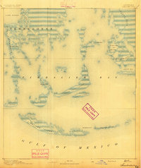
(375)- 1892 Map of Gibson
 1892 Gibson1892 Print · USGSCoastal Louisiana in the early 1890s is captured here as a landscape of bayous and new rail lines. Genealogists and historians can trace family land along Bayou Black or locate old railway stops at Gibson, Chacahoula, and Schriever.4 unique versions available
 - 1892 Map of Houma
 1892 Houma1892 Print · USGSCoastal Louisiana in the 1890s shows a landscape of waterborne commerce and rising rail lines. Genealogists and historians can trace old homesteads along Bayou Lafourche or study the early street grid of Houma and the path of the Southern Pacific Railroad.4 unique versions available
 - 1892 Map of Thibodaux, 1898 Print
 1892 Thibodaux1898 Print · USGSCajun country at the end of the nineteenth century is defined here by the winding course of Bayou Lafourche and its riverside communities. Genealogists and local historians can trace the early footprints of Thibodeaux and Labadieville alongside rail lines like the Southern Pacific Railroad.3 unique versions available
 - 1894 Map of Timbalier
 1894 Timbalier1894 Print · USGSCoastal Louisiana at the end of the nineteenth century reveals a shifting world of barrier islands and isolated maritime outposts. Researchers can trace the early positions of the Timbalier Light and small camps such as Philo Brice or Jacko Camp.3 unique versions available
 - 1894 Map of Bayou De Large
 1894 Bayou De Large1894 Print · USGSCoastal Louisiana at the end of the nineteenth century reveals a landscape defined by its shifting bayous and vast interior lakes. Researchers can trace early settlement patterns along Bayou De Large and locate landmarks like Lake Washa and Bayou Grand Caillou.4 unique versions available
 - 1894 Map of Lake Felicity
 1894 Lake Felicity1894 Print · USGSCoastal Louisiana in the early 1890s reveals a wild landscape of sprawling marshes and intricate bayous at the edge of the Gulf. Researchers can trace historic waterways like Bayou Du Chien and St. Jean Charles Bayou or locate Lake Billiot and Catfish Lake.3 unique versions available
 - 1894 Map of Dulac
 1894 Dulac1894 Print · USGSCoastal Terrebonne Parish appears here in the early 1890s, when life followed the natural rhythms of the bayous and marsh. Researchers can trace early water routes and family settlements near Montegut, Dulac, and the winding Bayou Grand Caillou.3 unique versions available
 - 1897 Map of Gibson
 1897 Gibson1897 Print · USGSCoastal Louisiana in the late nineteenth century was a world defined by its waterways and the rising influence of the rail. Genealogists and researchers can trace the early layout of bayou settlements like Schriever, Ellendale, and Chacahoula along the Southern Pacific Railroad.
 - 1932 Map of Lake Decade
 1932 Lake Decade1932 Print · USGSCoastal Terrebonne Parish in the early thirties is a vast network of salt marshes and tidal bays just before the era of intensive coastal engineering. Genealogists and historians can trace isolated landmarks like Steinbergs Camp or navigate the intricate reaches of Rice Bayou and Lost Lake.
 - 1932 Map of Houma SE
 1932 Houma SE1932 Print · USGSCoastal Louisiana in the early thirties reveals a landscape defined by the intersection of marshland and new navigation projects. Genealogists and local historians can trace family locations near Aragon Plantation, Bisland Cem, and the village of Bourg.
 - 1932 Map of Houma SW
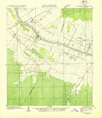
 1932 Houma SW1932 Print · USGSCoastal Louisiana at the height of the early thirties shows a region defined by its water-bound industry and growing infrastructure. Genealogists and historians can trace family-named sites like Southdown and Ashland, or locate rural landmarks such as Jerusalem Ch and the Bayou Cane Sch.
 - 1932 Map of Houma NW
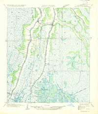
 1932 Houma NW1932 Print · USGSLafourche and Terrebonne Parishes appear here in the early 1930s, showing a landscape shaped by linear bayou settlements and drainage canals. Researchers can trace rural community life through sites like St Louis Chapel, Theriot Siding, and Porche Sch.
 - 1932 Map of Thibodaux SE
 1932 Thibodaux SE1932 Print · USGSLafourche Parish is captured in the early 1930s, revealing a landscape of historic bayou settlements and extensive sugar plantations. Genealogists can trace family lands and community landmarks from Laurel Valley Plantation to Blue Lily Cem and the Choupic Sch.
 - 1932 Map of Thibodaux SW
 1932 Thibodaux SW1932 Print · USGSBayou Lafourche during the early thirties is a landscape of expansive sugar estates and bustling rail lines. Genealogists can locate family lands and landmarks like Labadieville, Cedar Grove Plantation, and the Brule Guillot Sch.
 - 1935 Map of Cocodrie
 1935 Cocodrie1935 Print · USGSCoastal Louisiana marshes in the mid-1930s present a complex world of tidewater channels and expansive bays. Researchers can trace the original shorelines of Bay Sainte Elaine, Cooke Pt, and the winding course of Little Cocodrie Bayou.
 - 1935 Map of Theriot
 1935 Theriot1935 Print · USGSTerrebonne Parish’s coastal marshes and bayou communities are detailed here during the mid-1930s. Genealogists and local historians can trace the early drainage and transit network through the Marmande Canal, Theriot P O, and an ancient Indian Mound.
 - 1935 Map of Bourbeux
 1935 Bourbeux1935 Print · USGSThe coastal marsh of Terrebonne Parish is captured in the mid-1930s, showing a complex web of waterways before significant land loss altered the delta. Genealogists and maritime historians can trace traditional routes along Bayou Terrebonne, Lake Tambour, and Grand Bayou Bourbeux.
 - 1935 Map of Viguerie Canal
 1935 Viguerie Canal1935 Print · USGSThe Louisiana wetlands in the mid-1930s reveal a landscape of coastal bayous and early engineering. Trace the historic route of State Highway No. 968 as it winds alongside Bayou Pointe Au Chien and Lake Bully Camp.
 - 1935 Map of Montegut
 1935 Montegut1935 Print · USGSCoastal Terrebonne Parish comes to life in the mid-1930s, documenting a time when bayou-side settlements were the heart of the region. Genealogists and local historians can trace early footprints at Sarah Plantation, the Dugas Cem, and La Cache School.
 - 1935 Map of Timbalier Island
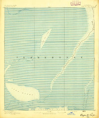
 1935 Timbalier Island1935 Print · USGSThe Louisiana coastline in the mid-1930s reveals a complex system of barrier islands and marshy bays before decades of significant environmental change. Trace the early shoreline of Timbalier Island and locate survey landmarks like James, King 2, and the Casse-Tete Islands.
 - 1935 Map of Morgan City
 1935 Morgan City1935 Print · USGSIn the mid-thirties, the Atchafalaya delta was a vital crossroads of the Old Spanish Trail and Southern Pacific rail lines. Genealogists and historians can trace family locations from Fairview Plantation to the Bradley Family Cem and the Bayou Black Settlement.
 - 1935 Map of Lake Mechant
 1935 Lake Mechant1935 Print · USGSThe Louisiana coastal marshes of Terrebonne Parish are shown in the mid-1930s, mapping a labyrinth of water and silt. Trace the old waterway routes through Lake Mechant to find landmarks like Hogs Point and the remote settlement of Merchant.
 - 1935 Map of Lake Quitman
 1935 Lake Quitman1935 Print · USGSCoastal Terrebonne Parish is captured in the mid-1930s just as aerial survey techniques were refining our view of the marsh. Genealogists and historians can trace property lines and early roads along Petit Caillou or locate the Indian Mound near Lake Quitman.
 - 1935 Map of Lake Gero
 1935 Lake Gero1935 Print · USGSIn the mid-1930s, the Terrebonne Parish wetlands were a complex weave of water and work. Genealogists can trace family footprints at St Michaels Plantation, Dulac PO, and the Grand Caillou Sch along the bayous.
 - 1935 Map of Lake Penchant
 1935 Lake Penchant1935 Print · USGSCoastal Terrebonne Parish in the mid-1930s is a world of interconnected marshland and tidal waters. Genealogists and local historians can trace early settlements like Carrion and Capasaw alongside navigable waterways such as Billiot Canal and Bayou Penchant.
Showing maps 1-25 of 375
Top cities of Terrebonne Parish
Frequently asked questions
- What are the different types of historical maps available for Terrebonne Parish?
- What is the oldest map of Terrebonne Parish?
- Where can I purchase historical maps of Terrebonne Parish for my home or office?
- Where can I download high-res historical maps of Terrebonne Parish?
- Are there historical topographic maps available for Terrebonne Parish?
- Is there historical aerial imagery available for Terrebonne Parish?
- Where are historical maps of Terrebonne Parish sourced from?