Old Maps of Kaplan, Louisiana for Genealogy
Trace your family roots with 27 historic maps of Kaplan. These high-res maps reveal old neighborhoods, homesites, landmarks, and streets — helping you uncover where your ancestors lived and how the area evolved over time.
- Explore historic neighborhoods: Identify where your relatives may have lived in the 1800s or 1900s.
- Compare maps over time: Trace the changes in streets, buildings, and landmarks for multi-generational research.
- Perfect for genealogy & ancestry research: Used by family historians and researchers to map out lineage and migration.
These maps are an incredible resource for exploring your personal connection to Kaplan's past.
Kaplan, LA maps
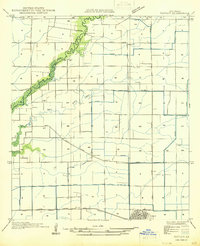
(27)- 1946 Map of Schooner Bayou NE
 1946 Schooner Bayou NE1946 Print · USGSCoastal Vermilion Parish in the mid-forties shows a landscape of prairie agriculture and marshland managed by a dense network of canals. Genealogists can locate family landmarks such as Hebert Cem, the Broussard Sch, and the pumping station at Pine Island.
 - 1946 Map of Kaplan
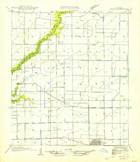
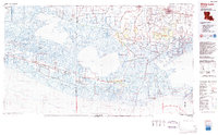
 1946 Kaplan1946 Print · USGSVermilion and Acadia Parishes come to life in the mid-1940s as the rice-farming landscape of southwest Louisiana expands. Trace the early streets of Kaplan, the Southern Pacific rail line, and rural landmarks like the Apshire Cem and Leleux.
 - 1952 Map of Lake Charles
 1952 Lake Charles1952 Print · USGSSouthwest Louisiana is captured here in the mid-fifties, showing a landscape defined by the rise of the petrochemical industry and deep-water navigation. Researchers can trace family roots through numerous small-town settlements and oil developments like Nibletts Bluff, the Lockport Oil Field, and Starks.
 - 1954 Map of Kaplan
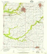
 1954 Kaplan1954 Print · USGSCoastal prairie life and agricultural development define this mid-century look at the Vermilion Parish countryside. Genealogists and local historians can trace the Southern Pacific rail line, locate the Apshire Cem, and find small communities like Leleux or Cossinade.
 - 1954 Map of Schooner Bayou NE
 1954 Schooner Bayou NE1954 Print · USGSThe Vermilion Parish marshlands and rice country are captured here at mid-century, centered on the rail hub at Kaplan. Researchers can locate family landmarks like Hebert Cem and the Broussard Sch among a complex network of drainage canals.
 - 1954 Map of Port Arthur
 1954 Port Arthur1954 Print · USGSThe Texas and Louisiana coastlines meet here in the mid-fifties, showing the industrial rise of Port Arthur alongside vast wildlife preserves. Researchers can trace remote coastal settlements and infrastructure like Pecan Island, the Sabine Pass Lighthouse, and the North Island School.
 - 1954 Map of Lake Charles, 1964 Print
 1954 Lake Charles1964 Print · USGSSouthwest Louisiana in the mid-fifties is defined by its massive petroleum industry and its complex network of bayous and rail lines. Researchers can trace the development of the Sulphur Mines Oil Field or locate historic settlements like Longville and De Quincy.3 unique versions available
 - 1955 Map of Crowley, 1956 Print
 1955 Crowley1956 Print · USGSAcadia Parish and the northern edge of Vermilion Parish are shown in the mid-fifties, during a period of agricultural and industrial expansion. Researchers can trace family history through numerous rural landmarks like Hebron Ch, Woodlawn Cem, and Simon Cem.4 unique versions available
 - 1955 Map of Forked Island, 1956 Print
 1955 Forked Island1956 Print · USGSCoastal Vermilion Parish marshlands come to life in the 1950s, showing the intersection of new industry and old maritime routes. Genealogists can trace family roots through sites like St Davids Ch, Hebert Cem, and the private airstrips at Kaplan.2 unique versions available
 - 1956 Map of Port Arthur, 1965 Print
 1956 Port Arthur1965 Print · USGSThe Texas and Louisiana coastlines meet here in the mid-fifties, showing a landscape of sprawling marshes and growing refinery towns. Genealogists and historians can trace ridge settlements like Grand Cheniere or find the Sabine Pass Lighthouse and Pecan Island.3 unique versions available
 - 1958 Map of Port Arthur
 1958 Port Arthur1958 Print · USGSThe Texas and Louisiana coastlines meet in the late fifties at the busy industrial port of Port Arthur. Historians and genealogists can trace the early rail networks of the Southern Pacific and locate coastal settlements like Cameron, Pecan Island, and Abbeville.
 - 1959 Map of Port Arthur
 1959 Port Arthur1959 Print · USGSThe Texas and Louisiana coastlines meet in this late-fifties study of a landscape defined by industry and wildlife preserves. Trace the Intracoastal Waterway past Pecan Island and Abbeville, or locate the shipping channels at Sabine Pass.
 - 1973 Map of Port Arthur, 1974 Print
 1973 Port Arthur1974 Print · USGSThe Texas-Louisiana borderlands in the early seventies reveal an intricate landscape of coastal marshes and heavy industry. Trace the growth of Port Arthur, the extent of the oil and gas fields, and old ridge settlements like Pecan Island.
 - 1979 Map of Kaplan South, 1980 Print
 1979 Kaplan South1980 Print · USGSCoastal Louisiana in the late seventies is captured here at the transition from farm to marsh. Researchers can trace family roots at St Ann Cem, find the rural settlement of Cow Island, or locate aviation landmarks like Harrington Landing Field.
 - 1983 Map of White Lake
 1983 White Lake1983 Print · USGSCoastal Louisiana at the start of the 1980s reveals a world of remote chenier settlements and vast marshlands. Genealogists and historians can trace family locations along Grand Chenier Ridge or explore the hubs of Abbeville and Intracoastal City.2 unique versions available
 - 1983 Map of Kaplan North
 1983 Kaplan North1983 Print · USGSVermilion Parish in the early eighties shows a landscape of prairie agriculture and water management north of the town center. Genealogists and local historians can locate family landmarks like Abshire Cem, the Meaux Landing Strip, and the winding Bayou Queue De Tortue.
 - 1985 Map of Crowley, 1986 Print
 1985 Crowley1986 Print · USGSCoastal prairie and bayou country are captured in the mid-eighties as the rice-and-rail economy defined South Louisiana life. Genealogists and researchers can trace family lands and rural hubs from Crowley to Jennings, following the paths of the Southern Pacific Railroad and the winding Mermentau River.2 unique versions available
 - 2012 Map of Kaplan North, 2012 Print
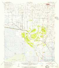
 2012 Kaplan North2012 Print · USGSCovers Kaplan, including Leleux, Cossinade, and other nearby areas
 - 2012 Map of Kaplan South, 2012 Print
 2012 Kaplan South2012 Print · USGSCovers Kaplan, including Vermilion Parish, United States, and other nearby areas
 - 2015 Map of Kaplan North, 2015 Print
 2015 Kaplan North2015 Print · USGSCovers Kaplan, including Leleux, Cossinade, and other nearby areas
 - 2015 Map of Kaplan South, 2015 Print
 2015 Kaplan South2015 Print · USGSCovers Kaplan, including Vermilion Parish, United States, and other nearby areas
 - 2018 Map of Kaplan South, 2018 Print
 2018 Kaplan South2018 Print · USGSCovers Kaplan, including Vermilion Parish, United States, and other nearby areas
 - 2018 Map of Kaplan North, 2018 Print
 2018 Kaplan North2018 Print · USGSCovers Kaplan, including Leleux, Cossinade, and other nearby areas
 - 2020 Map of Kaplan South, 2020 Print
 2020 Kaplan South2020 Print · USGSCovers Kaplan, including Vermilion Parish, United States, and other nearby areas
 - 2020 Map of Kaplan North, 2020 Print
 2020 Kaplan North2020 Print · USGSCovers Kaplan, including Leleux, Cossinade, and other nearby areas
Showing maps 1-25 of 27
Top cities near Kaplan
- Lafayette historical maps
- Crowley historical maps
- Abbeville historical maps
- Rayne historical maps
- Scott historical maps
- Duson historical maps
See more
Frequently asked questions
- What are the different types of historical maps available for Kaplan?
- What is the oldest map of Kaplan?
- Where can I purchase historical maps of Kaplan for my home or office?
- Where can I download high-res historical maps of Kaplan?
- Are there historical topographic maps available for Kaplan?
- Is there historical aerial imagery available for Kaplan?
- Where are historical maps of Kaplan sourced from?