1980s Maps of Saint Croix Township, Maine
Explore 5 historic maps of Saint Croix Township from the 1980s. These maps offer a rare glimpse into what life looked like during the 1980s — showing old roads, neighborhoods, homes, and landmarks that have changed or disappeared over time.
Whether you're researching your family's past, planning a metal detecting trip, or studying how Saint Croix Township's landscape evolved across the 1980s, these high-resolution maps are a powerful tool for exploring the history of this region.
- Focus on a specific era: All maps on this page are from the 1980s, giving you a focused view of this time period.
- See what’s changed: Compare century-old streets, trails, and buildings to today's modern landscape using overlays and satellite layers.
- Research with precision: Use these maps for genealogy, historical research, land use analysis, or educational projects.
- View, download, or print: Maps are fully viewable online in high resolution, and can be downloaded or printed for your own records.
Start exploring Saint Croix Township's history through authentic maps from the 1980s. This is your window into the past.
Saint Croix Township, ME maps
(5)- 1985 Map of Oakfield
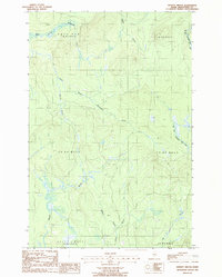
 1985 Oakfield1985 Print · USGSAroostook County in the 1980s displays a balance between the timber-and-rail industry and the protected wilderness of the North Woods. Genealogists and local historians can trace family-named hubs like Smyrna Mills, Island Falls, and Knowles Corner along the Bangor and Aroostook railroad line.
 - 1986 Map of St. Croix Lake
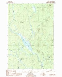 1986 St. Croix Lake1986 Print · USGSIn the remote woods of Aroostook County during the mid-1980s, these northern townships remained defined by their water systems and isolated settlements. Researchers can trace the early layout of Howe Brook, the railroad siding at Weeksboro, and old timber landmarks like Roll Dam Brook.
 - 1986 Map of Spinney Brook, 1987 Print
 1986 Spinney Brook1987 Print · USGSAroostook County's deep woods are captured here in the mid-1980s, showing a landscape defined by timber tracts and a complex network of waterways. Genealogists and historians can trace the paths of Spinney Brook and Tie Camp Brook through townships like Squapan.
 - 1986 Map of Griswold, 1987 Print
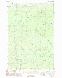
 1986 Griswold1987 Print · USGSAroostook County's timberlands are captured here in the mid-1980s, documenting the remote reaches of the North Maine Woods. Researchers can trace the legacy of land management and settlement through labels like Griswold, Hawkins, and the rugged peaks of Pollard Mtn.
 - 1986 Map of Mc Nally Ridge, 1987 Print
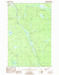
 1986 Mc Nally Ridge1987 Print · USGSNorthwestern Aroostook County is shown here in the 1980s as a landscape of timberlands and winding waterways. Genealogists and historians can trace old township lines like Webbertown and locate landmarks such as Roadside Park and Roll Dam Brook.
End of results
Showing maps 1-5 of 5
Top cities near Saint Croix Township
- Ashland historical maps
- Oakfield historical maps
- New Limerick historical maps
- Westfield historical maps
- Smyrna historical maps
- Ludlow historical maps
See more
Top neighborhoods of Saint Croix Township
Frequently asked questions
- What are the different types of historical maps available for Saint Croix Township?
- What is the oldest map of Saint Croix Township?
- Where can I purchase historical maps of Saint Croix Township for my home or office?
- Where can I download high-res historical maps of Saint Croix Township?
- Are there historical topographic maps available for Saint Croix Township?
- Is there historical aerial imagery available for Saint Croix Township?
- Where are historical maps of Saint Croix Township sourced from?