Old Maps of Kennebec County, Maine for Hiking & Exploration
Hike through history with 252 historic maps of Kennebec County. Explore old trails, ghost towns, and forgotten backroads — perfect for outdoor adventurers and local explorers.
- Rediscover forgotten places: Map out old mining camps, roads, and footpaths that no longer exist on modern maps.
- Layer with modern tools: Combine with LiDAR or satellite views to plan hikes through historical terrain.
- Made for exploration: Popular among hikers, overlanders, and local history lovers.
Use these maps to find adventure and explore the hidden past of Kennebec County.
Kennebec County, ME maps
(252)- 1892 Map of Gardiner
 1892 Gardiner1892 Print · USGSThe Kennebec River valley in the 1890s was a bustling corridor of rail and river commerce. Genealogists and historians can trace old homesteads and landings from Gardiner down to Bowdoinham, including points like Ship Yard Pt and the grounds of the Richmond Campmeeting.7 unique versions available
 - 1892 Map of Waterville
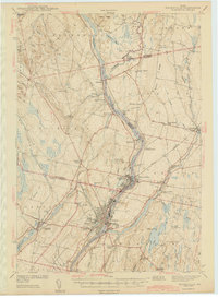
 1892 Waterville1892 Print · USGSCentral Maine thrived along the river valleys during the late nineteenth-century rail boom. Researchers can trace the development of the Maine Central Railroad through Waterville or locate older river crossings like Pishon Ferry.7 unique versions available
 - 1892 Map of Augusta
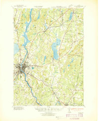
 1892 Augusta1892 Print · USGSAugusta and the Kennebec River valley are captured here in the 1890s, during a peak era of rail transport and riverfront industry. Genealogists and historians can trace old homesteads and depots along the Maine Central Railroad from Winthrop to Belgrade.8 unique versions available
 - 1893 Map of Vassalboro
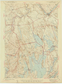
 1893 Vassalboro1893 Print · USGSMaine's heartland in the 1890s reveals a network of mill villages and lakeside settlements along the Kennebec River. Genealogists can trace early homesteads and landmarks near China Lake, North Vassalboro, and the rural crossroads of Weeks Mills.5 unique versions available
 - 1893 Map of Wiscasset
 1893 Wiscasset1893 Print · USGSThe coastal and inland reaches of Lincoln County come alive in the 1890s, centered on the shipping and rail hub of Wiscasset. Trace the paths of the Maine Central Railroad and find early settlements like Head Tide, Dresden Mills, and Damariscotta Mills.7 unique versions available
 - 1894 Map of Norridgewock
 1894 Norridgewock1894 Print · USGSSomerset and Kennebec counties are shown at the height of the Victorian era, characterized by an intricate network of glacial lakes and river ferries. Genealogists can trace early homesteads and transport points like Davis Ferry, Belgrade Mills, and South Norridgewock.
 - 1898 Map of Norridgewock
 1898 Norridgewock1898 Print · USGSSomerset and Kennebec Counties are shown here during the late Victorian era as the river-and-rail economy thrived. Genealogists can trace family holdings and old crossings like Davis Ferry, Belgrade Mills, and the historic village of Norridgewock.5 unique versions available
 - 1898 Map of Vassalboro, 1935 Print
 1898 Vassalboro1935 Print · USGSKennebec County at the close of the nineteenth century reveals a landscape of mill towns and interconnected lakes. Researchers can trace the early industrial footprint at Weeks Mills and Cooper Mills or follow the path of the Maine Central R.R. along the Kennebec River.
 - 1908 Map of Lewiston
 1908 Lewiston1908 Print · USGSAndroscoggin County at the start of the century shows a thriving industrial corridor centered on the twin cities and the river. Genealogists can trace family farms and local institutions near Sabattus Pond, Bates College, and Lisbon Falls.6 unique versions available
 - 1910 Map of Livermore, 1959 Print
 1910 Livermore1959 Print · USGSMaine's river valleys and lake districts are captured here in the early twentieth century, showing a network of rail-reliant mill towns and rural crossroads. Genealogists can locate family landmarks like Howes Corner and Brettuns Mills, or trace local schools like Saunders School.
 - 1912 Map of Livermore
 1912 Livermore1912 Print · USGSMaine's lake district comes to life in this pre-war survey of the Androscoggin River valley. Genealogists and historians can trace old homesteads and landmarks like Brettuns Mills Livermore P O, Strickland Ferry, and Monmouth Academy.5 unique versions available
 - 1916 Map of Liberty
 1916 Liberty1916 Print · USGSMid-coast Maine at the start of the Great War was a patchwork of small townships and family farmsteads connected by narrow-gauge rails. Researchers can locate dozens of country schools and named crossroads such as The Kingdom, Hibberts Gore, and Woodmans Mills.6 unique versions available
 - 1924 Map of Farmington
 1924 Farmington1924 Print · USGSFranklin County in the early 1920s is a landscape of river-powered mills and intersecting rail lines, including the Sandy River and Rangeley Lakes RR. Genealogists can locate dozens of country schools and rural settlements like Allens Mills and Knowltons Corner.6 unique versions available
 - 1926 Map of Burnham
 1926 Burnham1926 Print · USGSWaldo and Kennebec counties in the mid-1920s are captured here as a landscape of rural schoolhouses and family-named corners centered on the Sebasticook River. Genealogists can trace family roots through landmarks like Quaker Hill Church, the Freedom Town House, and dozens of district sites like Beech Hill School.3 unique versions available
 - 1941 Map of Livermore
 1941 Livermore1941 Print · USGSAndroscoggin County at the start of the 1940s is a landscape defined by the river and rail economy between Livermore Falls and Wayne. Genealogists can trace family footprints across numerous rural districts, locating Brettuns Mills and the many schoolhouses like Young Sch and Pike Sch.
 - 1941 Map of Vassalboro, 1954 Print
 1941 Vassalboro1954 Print · USGSCentral Maine in the early 1940s reveals a landscape of lakeside settlements and scattered rural schoolhouses between the Kennebec and Sheepscot rivers. Genealogists can trace family roots through sites like Oak Grove Seminary, Friends Cem, and Weeks Mills.2 unique versions available
 - 1941 Map of Augusta, 1956 Print
 1941 Augusta1956 Print · USGSThe Kennebec River valley and its surrounding lake country are documented here just before the mid-century, showing the capital's growth alongside quiet rural townships. Genealogists can locate family-named sites like Stevens Cem, several small schoolhouses including Cony Sch, and the rail stops at Readfield Depot.
 - 1942 Map of Lewiston
 1942 Lewiston1942 Print · USGSLewiston and the Androscoggin River valley are shown in detail during the early 1940s, capturing the area's transition from industrial hubs to rural crossroads. Researchers can locate early schoolhouses like No Name Sch, the campus of Bates College, and vanished rail stops at Golder Siding and Leeds Junc.
 - 1942 Map of Liberty
 1942 Liberty1942 Print · USGSWaldo and Lincoln County lands are documented here just before mid-century, showing a landscape of rural schools and family-named corners. Genealogists can trace property near Hibberts Gore or locate ancestral homesites near Handy Sch and Montville Post Office.
 - 1943 Map of Augusta
 1943 Augusta1943 Print · USGSAugusta and the surrounding Kennebec County lakes are shown in detail during the early 1940s as the rail and river economies converged. Genealogists can locate family plots at Lakeview Cem, trace old school districts like Ballard Sch, and find landmarks like the Fish Hatchery.3 unique versions available
 - 1943 Map of Gardiner
 1943 Gardiner1943 Print · USGSThe Kennebec River valley in the early 1940s reveals a landscape of riverside industry and inland farming communities. Researchers can trace ancestral roots through dozens of local schoolhouses like J F Stevens Sch and family crossroads such as Spears Cor or Starbird Cor.4 unique versions available
 - 1943 Map of Vassalboro
 1943 Vassalboro1943 Print · USGSCentral Maine in the early 1940s is a landscape of expansive lake systems and interconnected mill villages. Researchers can trace the heritage of local institutions like Oak Grove Seminary, the stop at Windsor Station, and the historic Friends Cem.
 - 1943 Map of Norridgewock
 1943 Norridgewock1943 Print · USGSSomerset and Kennebec counties are shown here just after the start of the war, when the Maine Central railroad still connected these rural river towns. Researchers can locate specific family landmarks including the Whitehouse Cem, Hersom Sch, and the Norridgewock Rearing Pool.3 unique versions available
 - 1943 Map of Waterville
 1943 Waterville1943 Print · USGSThe Kennebec and Sebasticook river valleys are shown in detail during the early 1940s, highlighting the rail hubs of Waterville and Winslow. Genealogists can trace family landmarks like Pratt Cem or the rural Covell Sch and Ten Lots Chapel.2 unique versions available
 - 1944 Map of Wiscasset
 1944 Wiscasset1944 Print · USGSThe Sheepscot and Damariscotta rivers define this mid-coast Maine region in the 1940s as the rail and river economy persists. Trace family history at Head Tide, the Whitefield Memorial Hospital, or early schoolhouses like Alna Center Sch.4 unique versions available
Showing maps 1-25 of 252
Top cities of Kennebec County
- Augusta historical maps
- Waterville historical maps
- Winslow historical maps
- Oakland historical maps
- Winthrop historical maps
- Gardiner historical maps
See more
Frequently asked questions
- What are the different types of historical maps available for Kennebec County?
- What is the oldest map of Kennebec County?
- Where can I purchase historical maps of Kennebec County for my home or office?
- Where can I download high-res historical maps of Kennebec County?
- Are there historical topographic maps available for Kennebec County?
- Is there historical aerial imagery available for Kennebec County?
- Where are historical maps of Kennebec County sourced from?