1940s Maps of Knox County, Maine
Explore 12 historic maps of Knox County from the 1940s. These maps offer a rare glimpse into what life looked like during the 1940s — showing old roads, neighborhoods, homes, and landmarks that have changed or disappeared over time.
Whether you're researching your family's past, planning a metal detecting trip, or studying how Knox County's landscape evolved across the 1940s, these high-resolution maps are a powerful tool for exploring the history of this region.
- Focus on a specific era: All maps on this page are from the 1940s, giving you a focused view of this time period.
- See what’s changed: Compare century-old streets, trails, and buildings to today's modern landscape using overlays and satellite layers.
- Research with precision: Use these maps for genealogy, historical research, land use analysis, or educational projects.
- View, download, or print: Maps are fully viewable online in high resolution, and can be downloaded or printed for your own records.
Start exploring Knox County's history through authentic maps from the 1940s. This is your window into the past.
Knox County, ME maps
(12)- 1941 Map of Belfast
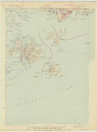
 1941 Belfast1941 Print · USGSCoastal Waldo County at the start of the 1940s reveals a landscape of tidal rivers and bustling rural crossroads. Genealogists and historians can trace family locations through numerous landmarks like Allens Hall, Holmes Mill, and the Belfast & Moosehead Lake RR corridor.
 - 1941 Map of Rockland
 1941 Rockland1941 Print · USGSThe Knox County shoreline during the early 1940s features a detailed look at maritime life and coastal industry. Genealogists and historians can trace the foundations of Rockland, locate the Rockland Breakwater Lighthouse, and explore villages like South Thomaston and Wattons Mill.
 - 1941 Map of Waldoboro
 1941 Waldoboro1941 Print · USGSThe Medomak River valley and its surrounding coastal hills are captured here just as the war began. You can trace early twentieth-century rail connections at Glendon Station, find family-named crossroads like Whitney Corner, and locate local landmarks such as Winslows Mills.
 - 1941 Map of Vinalhaven, 1962 Print
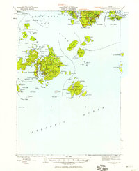
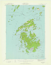 1941 Vinalhaven1962 Print · USGSPenobscot Bay is captured in high detail during the early 1940s, showing the intricate island communities of the Fox Islands. Researchers can trace family sites near Seaview Cem, locate maritime landmarks like Heron Neck L H, and explore the geography of Hurricane Island.3 unique versions available
 - 1942 Map of Liberty
 1942 Liberty1942 Print · USGSWaldo and Lincoln County lands are documented here just before mid-century, showing a landscape of rural schools and family-named corners. Genealogists can trace property near Hibberts Gore or locate ancestral homesites near Handy Sch and Montville Post Office.
 - 1942 Map of Deer Isle, 1958 Print
 1942 Deer Isle1958 Print · USGSCoastal Maine life in the 1940s centers on the granite industry and maritime trade routes throughout Deer Isle and the Penobscot Bay islands. Genealogists and historians can trace the foundations of local economies through the QUARRIES at Stonington and the many family-named landmarks like Greenlaw Neck or Conary Head.3 unique versions available
 - 1943 Map of Swans Island, 1958 Print
 1943 Swans Island1958 Print · USGSCoastal Hancock County at the height of the Second World War reveals a landscape of isolated island communities and maritime commerce. Genealogists and historians can trace family roots through the settlements of Atlantic, Minturn, and Frenchboro, or locate landmarks like the Blue Hill Bay LH and Little Duck I Bird Sanctuary.3 unique versions available
 - 1944 Map of Vinalhaven
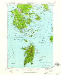
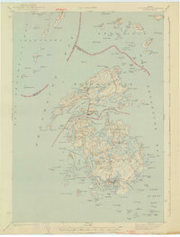 1944 Vinalhaven1944 Print · USGSThe Fox Islands of Maine are captured here during the 1940s, showing the intricate island-and-bay network of Penobscot Bay. Genealogists can trace early family sites like Fuller Cem and Browns Cem or locate maritime landmarks such as Browns Head LH.2 unique versions available
 - 1944 Map of Deer Isle
 1944 Deer Isle1944 Print · USGSPenobscot Bay and the Eggemoggin Reach appear here in the early 1940s, highlighting the granite and maritime hubs of the Maine coast. Genealogists and historians can locate family homes near Stonington, coastal Quarries, and landmarks like Forest Cem.2 unique versions available
 - 1945 Map of Swans Island
 1945 Swans Island1945 Print · USGSCoastal Maine's island communities thrive amidst the granite shores and deep harbors of Hancock County during the mid-1940s. Trace the isolated settlements of Atlantic, Minturn, and Frenchboro, or locate family sites like the Stockbridge Cem and the Blue Hill Bay LH.2 unique versions available
 - 1948 Map of Bangor
 1948 Bangor1948 Print · USGSThe Maine coast and its industrial river valleys are captured here shortly after the war, showing the vital shipping and rail hubs of the late 1940s. Genealogists and historians can trace the tracks of the Maine Central RR connecting Bangor, Augusta, and Old Town.
 - 1948 Map of Bath
 1948 Bath1948 Print · USGSMid-coast Maine’s intricate shoreline and island outposts are captured here just after the war. Researchers can trace historic maritime settlements from Bath to Friendship and locate remote landmarks like Monhegan Island and Pemaquid Point.2 unique versions available
End of results
Showing maps 1-12 of 12
Top cities of Knox County
- Rockland historical maps
- Warren historical maps
- Camden historical maps
- Rockport historical maps
- Thomaston historical maps
- Saint George historical maps
See more
Frequently asked questions
- What are the different types of historical maps available for Knox County?
- What is the oldest map of Knox County?
- Where can I purchase historical maps of Knox County for my home or office?
- Where can I download high-res historical maps of Knox County?
- Are there historical topographic maps available for Knox County?
- Is there historical aerial imagery available for Knox County?
- Where are historical maps of Knox County sourced from?