1980s Maps of Knox County, Maine
Explore 13 historic maps of Knox County from the 1980s. These maps offer a rare glimpse into what life looked like during the 1980s — showing old roads, neighborhoods, homes, and landmarks that have changed or disappeared over time.
Whether you're researching your family's past, planning a metal detecting trip, or studying how Knox County's landscape evolved across the 1980s, these high-resolution maps are a powerful tool for exploring the history of this region.
- Focus on a specific era: All maps on this page are from the 1980s, giving you a focused view of this time period.
- See what’s changed: Compare century-old streets, trails, and buildings to today's modern landscape using overlays and satellite layers.
- Research with precision: Use these maps for genealogy, historical research, land use analysis, or educational projects.
- View, download, or print: Maps are fully viewable online in high resolution, and can be downloaded or printed for your own records.
Start exploring Knox County's history through authentic maps from the 1980s. This is your window into the past.
Knox County, ME maps
(13)- 1982 Map of Vinalhaven, 1983 Print
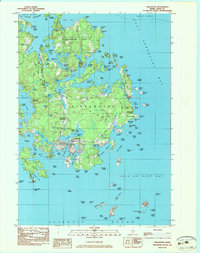 1982 Vinalhaven1983 Print · USGSVinalhaven and the surrounding islands are shown in the early 1980s, highlighting the area’s quarrying heritage and maritime culture. Researchers can trace family history at Hill Cem or locate industrial sites like Lawson Quarry Pond and the coastal Lighthouse.3 unique versions available
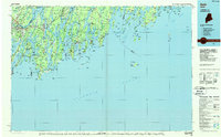
 - 1982 Map of Leadbetter Island, 1983 Print
 1982 Leadbetter Island1983 Print · USGSPenobscot Bay islands like Vinalhaven and North Haven are shown in the early eighties as a dense network of granite heights and tidal channels. Researchers can locate coastal landmarks including the Lighthouse at Browns Head, the Outward Bound Sch, and the inland waters of Dyer Pond.
 - 1982 Map of North Haven East, 1983 Print
 1982 North Haven East1983 Print · USGSThe Fox Islands archipelago in the early eighties highlights a seafaring community connected by the Fox Islands Thorofare and the North Haven Ferry. Genealogists can trace family lines through the Seaview Cem or explore the landing at The Wood Landing.
 - 1983 Map of Isle Au Haut West
 1983 Isle Au Haut West1983 Print · USGSThe coastal waters of Knox County in the early 1980s reveal a landscape of secluded island life and maritime heritage. Genealogists and historians can locate family landmarks like Turners Cem or trace the coastline past the Robinson Point Lighthouse and Saddleback Ledge Lighthouse.
 - 1983 Map of Johns Island
 1983 Johns Island1983 Print · USGSCoastal Hancock County in the early eighties is mapped here as an intricate network of remote islands and navigational ledges. Maritime researchers can trace the shorelines of Marshall Island, locate Acadia National Park boundaries on Heron I, and find Steamboat Beach in Frenchboro.
 - 1983 Map of Deer Isle
 1983 Deer Isle1983 Print · USGSDeer Isle and the busy harbor at Stonington appear in high detail during the early eighties. Researchers can trace family history at Mt Adams Cem or locate industrial sites like the quarries on Crotch Island and the Mark Island Lighthouse.
 - 1983 Map of Stinson Neck
 1983 Stinson Neck1983 Print · USGSCoastal Hancock County in the early eighties is captured here across the islands and reaches of Stinson Neck. Genealogists and historians can locate family-named points and settlements like Sunshine, Oceanville, and the Beth Eden Ch near Naskeag.
 - 1983 Map of North Haven West
 1983 North Haven West1983 Print · USGSMid-coast Maine’s maritime landscape is captured here in the early eighties, showing the intricate shorelines of Penobscot Bay. Genealogists and historians can trace coastal homesteads near Fuller Cem, landholdings on Seven Hundred Acre Island, and old routes like Main Road.
 - 1983 Map of Isle Au Haut East
 1983 Isle Au Haut East1983 Print · USGSCoastal Maine's rugged island chains are captured in the early 1980s, featuring the eastern edge of Acadia National Park. Researchers can trace old footpaths like the Sawyer Notch Trail or locate maritime landmarks from Sheep Thief Gulch to York Island.
 - 1984 Map of Augusta
 1984 Augusta1984 Print · USGSMid-coast and central Maine were undergoing steady change in the mid-eighties as traditional river and coastal industries met expanding recreation. You can trace the Maine Central RR through Augusta or explore the rugged shoreline from Rockland Harbor up to Mount Megunticook.
 - 1985 Map of Matinicus
 1985 Matinicus1985 Print · USGSThe outer islands of Knox County are captured in the mid-1980s, highlighting the isolated settlements of the Gulf of Maine. Genealogists and maritime historians can locate homes and landmarks in Matinicus and Criehaven, or trace the shores of Ragged Island and Seal Island.
 - 1985 Map of Bar Harbor
 1985 Bar Harbor1985 Print · USGSCoastal Hancock County in the mid-eighties shows an intricate landscape of island communities and protected wilderness. Trace the boundaries of Acadia National Park or locate seafaring hubs like Stonington and Bar Harbor.2 unique versions available
 - 1985 Map of Bath, 1986 Print
 1985 Bath1986 Print · USGSMidcoast Maine in the mid-eighties shows a landscape of deep-water harbors and strategic military installations. Researchers can trace the coastal rail lines of the Maine Central RR and locate landmarks from Popham Beach to the remote Monhegan Plantation.2 unique versions available
End of results
Showing maps 1-13 of 13
Top cities of Knox County
- Rockland historical maps
- Warren historical maps
- Camden historical maps
- Rockport historical maps
- Thomaston historical maps
- Saint George historical maps
See more
Frequently asked questions
- What are the different types of historical maps available for Knox County?
- What is the oldest map of Knox County?
- Where can I purchase historical maps of Knox County for my home or office?
- Where can I download high-res historical maps of Knox County?
- Are there historical topographic maps available for Knox County?
- Is there historical aerial imagery available for Knox County?
- Where are historical maps of Knox County sourced from?