1950s Maps of Knox County, Maine
Explore 18 historic maps of Knox County from the 1950s. These maps offer a rare glimpse into what life looked like during the 1950s — showing old roads, neighborhoods, homes, and landmarks that have changed or disappeared over time.
Whether you're researching your family's past, planning a metal detecting trip, or studying how Knox County's landscape evolved across the 1950s, these high-resolution maps are a powerful tool for exploring the history of this region.
- Focus on a specific era: All maps on this page are from the 1950s, giving you a focused view of this time period.
- See what’s changed: Compare century-old streets, trails, and buildings to today's modern landscape using overlays and satellite layers.
- Research with precision: Use these maps for genealogy, historical research, land use analysis, or educational projects.
- View, download, or print: Maps are fully viewable online in high resolution, and can be downloaded or printed for your own records.
Start exploring Knox County's history through authentic maps from the 1950s. This is your window into the past.
Knox County, ME maps
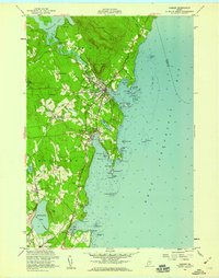
(18)- 1950 Map of Belfast
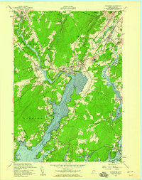
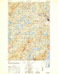 1950 Belfast1950 Print · USGSMid-century Waldo County comes to life as a network of crossroads hamlets and coastal industry before the modern highway era. Genealogists can trace family names across schoolhouses like Apple Sch and rural intersections such as Hayford Corner and Vickerys Corner.
 - 1950 Map of Liberty
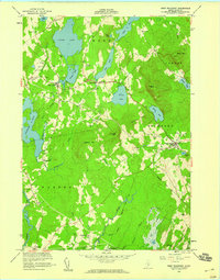
 1950 Liberty1950 Print · USGSMid-century Waldo County and its neighbors are defined here by a network of crossroad hamlets and upland ridges just after the war. Local historians can trace the foundations of The Kingdom, identify family sites near Hutchins Corner, or locate rural schoolhouses like Hallidale Sch.
 - 1950 Map of Waldoboro
 1950 Waldoboro1950 Print · USGSThe Medomak River valley and the coastal hills of Lincoln County are captured here in the mid-century, prior to modern suburban expansion. Genealogists and historians can locate old landmarks like Nobleboro Station, Winslow Mills, and numerous neighborhood schools like Duckpuddle Sch.
 - 1953 Map of Matinicus, 1959 Print
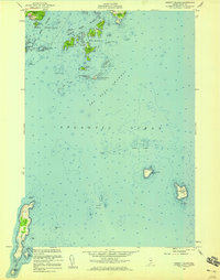
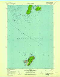
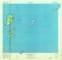 1953 Matinicus1959 Print · USGSThe outer islands of Knox County are captured here in the early 1950s, showing the remote maritime life of the Gulf of Maine. Genealogists and historians can trace the small settlements at Matinicus and Criehaven or locate the distant U S Coast Guard Reservation on Matinicus Rock.4 unique versions available
 - 1955 Map of New Harbor, 1958 Print
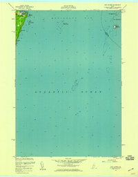 1955 New Harbor1958 Print · USGSThe Maine coast near New Harbor is captured here in the mid-1950s, showing the intersection of maritime life and land-based settlement. Researchers can trace the rocky shoreline of Pemaquid Neck and identify offshore landmarks like Eastern Egg Rock and Moser Ledge.3 unique versions available
 - 1955 Map of Rockland, 1959 Print
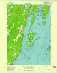
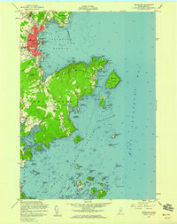 1955 Rockland1959 Print · USGSCoastal Maine in the mid-fifties comes alive in this survey of the Penobscot Bay shoreline and the Rockland harbor. Local historians can trace the aviation and maritime footprint of the era, from the Rockland Municipal Airport to the U S Coast Guard Sta and family-named cemeteries like Achorn Cem.5 unique versions available
 - 1955 Map of Thomaston, 1959 Print
 1955 Thomaston1959 Print · USGSThe Knox County coast is captured here in the mid-1950s, centered on the historic riverfront at Thomaston. Genealogists and historians can trace family burial sites like The Village Cemetery or locate landmarks such as the State Prison Farm.5 unique versions available
 - 1955 Map of Hewett Island, 1959 Print
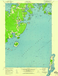
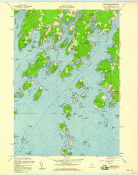
 1955 Hewett Island1959 Print · USGSCoastal Maine's intricate island chain is captured here in the mid-1950s, detailing the vital maritime passages and rugged archipelago south of Rockland. Researchers can trace the navigation aids of the era, from the U.S. Coast Guard Sta to landmarks like Hurricane Island and Whitehead Island.3 unique versions available
 - 1955 Map of Tenants Harbor, 1959 Print
 1955 Tenants Harbor1959 Print · USGSThe Knox County shoreline in the mid-fifties remains a world of working harbors and seafaring history. Genealogists and historians can trace family locations near Tenants Harbor, Martinsville, and the remote Metinic Island, or locate landmarks like Ridge Ch and Seaside Cem.5 unique versions available
 - 1955 Map of West Rockport, 1959 Print
 1955 West Rockport1959 Print · USGSMidcoast Maine in the mid-fifties reveals a landscape of high granite peaks and working waterpower sites across Knox County. Genealogists can locate family burial grounds and landmarks like Goulds Hospital, Wattons Mill, and East Union.5 unique versions available
 - 1955 Map of Louds Island, 1959 Print
 1955 Louds Island1959 Print · USGSCoastal Lincoln County is charted here in the mid-fifties, showing the deep-rooted maritime life between Muscongus and New Harbor. Researchers can trace families at Ocean Hill Cem, locate the island settlement of Loudville, and explore the docks of Round Pond.5 unique versions available
 - 1955 Map of Monhegan, 1959 Print
 1955 Monhegan1959 Print · USGSThe outer Maine coast comes to life in the mid-1950s, centered on the historic fishing and maritime hub of Monhegan. Local historians and genealogists can trace the isolated settlement's footprint, including the Lighthouse, the U S Coast Guard Reservation, and landmarks like Black Head.4 unique versions available
 - 1955 Map of Camden, 1959 Print
 1955 Camden1959 Print · USGSCoastal Maine centers on the busy harbors of the mid-1950s, showing the early expansion of coastal villages into the surrounding hills. Genealogists and historians can trace family plots in Oak Hill Cem or locate the old Fish Hatchery and Drive-in Theater.5 unique versions available
 - 1955 Map of Friendship, 1959 Print
 1955 Friendship1959 Print · USGSThe Maine coast near Friendship and Port Clyde is captured here during the mid-fifties, showing a landscape of working harbors and tidal rivers. Genealogists and historians can trace coastal family sites near Harbor Cem or the U S Coast Guard Station at the edge of the Georges Islands.3 unique versions available
 - 1956 Map of Bangor, 1966 Print
 1956 Bangor1966 Print · USGSMid-century Maine comes alive in this survey of the rugged coast and river valleys during the 1950s. Genealogists and historians can trace the vital rail corridors of the Maine Central RR connecting timber towns like Old Town to the coast at Bar Harbor.3 unique versions available
 - 1956 Map of Bath, 1974 Print
 1956 Bath1974 Print · USGSCoastal Maine in the mid-fifties reveals a landscape of deep-water harbors and island outposts as the region transitioned from industrial roots to a summer destination. Genealogists can trace maritime families in Boothbay Harbor, Tenants Harbor, and on remote Monhegan Island.
 - 1957 Map of Bath
 1957 Bath1957 Print · USGSThe Maine coast in the mid-fifties is captured here, from the shipbuilding hubs of Bath and Brunswick to the granite reaches of Rockland. Researchers can trace the Maine Central RR line and remote island outposts like Monhegan Island and Matinicus Isle.
 - 1958 Map of Bath
 1958 Bath1958 Print · USGSCoastal Maine in the late fifties reveals a landscape of industrial river towns and remote island outposts. Genealogists and historians can trace the Maine Central RR through Bath, explore the islands of Muscongus Bay, or locate seafaring families at Pemaquid Point.
End of results
Showing maps 1-18 of 18
Top cities of Knox County
- Rockland historical maps
- Warren historical maps
- Camden historical maps
- Rockport historical maps
- Thomaston historical maps
- Saint George historical maps
See more
Frequently asked questions
- What are the different types of historical maps available for Knox County?
- What is the oldest map of Knox County?
- Where can I purchase historical maps of Knox County for my home or office?
- Where can I download high-res historical maps of Knox County?
- Are there historical topographic maps available for Knox County?
- Is there historical aerial imagery available for Knox County?
- Where are historical maps of Knox County sourced from?