1900-1909 Maps of Knox County, Maine
Explore 11 historic maps of Knox County from 1900-1909. These maps offer a rare glimpse into what life looked like during the 1900s — showing old roads, neighborhoods, homes, and landmarks that have changed or disappeared over time.
Whether you're researching your family's past, planning a metal detecting trip, or studying how Knox County's landscape evolved across the 1900s, these high-resolution maps are a powerful tool for exploring the history of this region.
- Focus on a specific era: All maps on this page are from the 1900s, giving you a focused view of this time period.
- See what’s changed: Compare century-old streets, trails, and buildings to today's modern landscape using overlays and satellite layers.
- Research with precision: Use these maps for genealogy, historical research, land use analysis, or educational projects.
- View, download, or print: Maps are fully viewable online in high resolution, and can be downloaded or printed for your own records.
Start exploring Knox County's history through authentic maps from the 1900s. This is your window into the past.
Knox County, ME maps
(11)- 1904 Map of Deer Isle
 1904 Deer Isle1904 Print · USGSThe Maine coast in the early nineteen-hundreds is defined by its network of island settlements and steamboat paths. Genealogists and historians can trace family locations from Stonington to Isle au Haut, or locate maritime landmarks like Deer I. Thorofare L.H. and The Haulover.4 unique versions available
 - 1904 Map of Swan Island
 1904 Swan Island1904 Print · USGSThe granite shores of Hancock County appear here at the turn of the century, showing a network of island villages and maritime routes. Trace the old foundations and landing sites at Frenchboro and Minturn, or locate the Bluehill Bay L.H. and early steamboat paths.4 unique versions available
 - 1904 Map of Vinalhaven
 1904 Vinalhaven1904 Print · USGSThe Fox Islands and Penobscot Bay are captured here at a maritime peak, when steamboats and granite quarries drove the local economy. Researchers can trace historic ferry paths and find family landmarks like Coombs Hill, Browns Head L.H., and the settlement at North Haven.4 unique versions available
 - 1904 Map of Monhegan, 1958 Print
 1904 Monhegan1958 Print · USGSThe Maine coast near Muscongus Bay is captured here during the heyday of coastal steamboats and lighthouse keepers. Genealogists and historians can trace families across Louds Island, Bremen Long Island, and the remote fishing community on Monhegan.
 - 1904 Map of Tenants Harbor, 1960 Print
 1904 Tenants Harbor1960 Print · USGSCoastal Maine at the turn of the century reveals a seafaring landscape shaped by granite islands and protected harbors. Genealogists and historians can trace old coastal settlements like Martinsville and Elmore or navigate the intricate Muscle Ridge Channel.
 - 1904 Map of Rockland, 1961 Print
 1904 Rockland1961 Print · USGSCoastal Knox County comes alive in this early twentieth-century survey of the harbor towns and the rocky Penobscot Bay shoreline. Trace the routes of the Maine Central RR and ELECTRIC lines to historic settlements like Blackinton Corners and Sharkeyville.
 - 1905 Map of Penobscot Bay
 1905 Penobscot Bay1905 Print · USGSThe Maine coastline at the dawn of the twentieth century was a bustling network of maritime trade and summer retreats. Genealogists and historians can trace the foundations of coastal life through the STEAMBOAT ROUTE, the Northport Camp Ground, and settlements like Sargentville.3 unique versions available
 - 1906 Map of Matinicus
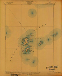 1906 Matinicus1906 Print · USGSCoastal Maine's most remote island communities are captured at the beginning of the twentieth century. Researchers can trace the early footprints of Matinicus and Criehaven, locate the Matinicus Rock LH, and follow the old Steamboat Route.4 unique versions available
 - 1906 Map of Tennant Harbor
 1906 Tennant Harbor1906 Print · USGSThe coastal waters of Knox County were a bustling corridor for maritime trade in the early 1900s. Genealogists and historians can trace the foundations of Tennant Harbor and Martinsville, while mapping the precise locations of offshore hazards like Roaring Bull and Metinic Island.4 unique versions available
 - 1906 Map of Monhegan
 1906 Monhegan1906 Print · USGSThe Maine coast at the turn of the century reveals a seafaring landscape of island outposts and sheltered harbors. Trace early maritime routes and family-named landmarks from Port Clyde to the isolated Monhegan Island.5 unique versions available
 - 1906 Map of Rockland
 1906 Rockland1906 Print · USGSCoastal Knox County comes alive in the first decade of the century, showing a bustling network of harbors and early transit systems. Genealogists and historians can trace family roots through crossroads like Blackinton Corners or investigate the old Wattons Mill and the Electric RR lines.7 unique versions available
End of results
Showing maps 1-11 of 11
Top cities of Knox County
- Rockland historical maps
- Warren historical maps
- Camden historical maps
- Rockport historical maps
- Thomaston historical maps
- Saint George historical maps
See more
Frequently asked questions
- What are the different types of historical maps available for Knox County?
- What is the oldest map of Knox County?
- Where can I purchase historical maps of Knox County for my home or office?
- Where can I download high-res historical maps of Knox County?
- Are there historical topographic maps available for Knox County?
- Is there historical aerial imagery available for Knox County?
- Where are historical maps of Knox County sourced from?