Old Maps of Knox County, Maine for Genealogy
Trace your family roots with 244 historic maps of Knox County. These high-res maps reveal old neighborhoods, homesites, landmarks, and streets — helping you uncover where your ancestors lived and how the area evolved over time.
- Explore historic neighborhoods: Identify where your relatives may have lived in the 1800s or 1900s.
- Compare maps over time: Trace the changes in streets, buildings, and landmarks for multi-generational research.
- Perfect for genealogy & ancestry research: Used by family historians and researchers to map out lineage and migration.
These maps are an incredible resource for exploring your personal connection to Knox County's past.
Knox County, ME maps
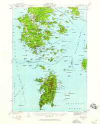
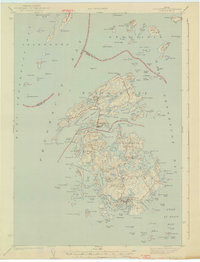
(244)- 1904 Map of Deer Isle
 1904 Deer Isle1904 Print · USGSThe Maine coast in the early nineteen-hundreds is defined by its network of island settlements and steamboat paths. Genealogists and historians can trace family locations from Stonington to Isle au Haut, or locate maritime landmarks like Deer I. Thorofare L.H. and The Haulover.4 unique versions available
 - 1904 Map of Swan Island
 1904 Swan Island1904 Print · USGSThe granite shores of Hancock County appear here at the turn of the century, showing a network of island villages and maritime routes. Trace the old foundations and landing sites at Frenchboro and Minturn, or locate the Bluehill Bay L.H. and early steamboat paths.4 unique versions available
 - 1904 Map of Vinalhaven
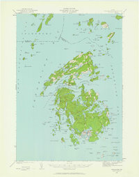
 1904 Vinalhaven1904 Print · USGSThe Fox Islands and Penobscot Bay are captured here at a maritime peak, when steamboats and granite quarries drove the local economy. Researchers can trace historic ferry paths and find family landmarks like Coombs Hill, Browns Head L.H., and the settlement at North Haven.4 unique versions available
 - 1904 Map of Monhegan, 1958 Print
 1904 Monhegan1958 Print · USGSThe Maine coast near Muscongus Bay is captured here during the heyday of coastal steamboats and lighthouse keepers. Genealogists and historians can trace families across Louds Island, Bremen Long Island, and the remote fishing community on Monhegan.
 - 1904 Map of Tenants Harbor, 1960 Print
 1904 Tenants Harbor1960 Print · USGSCoastal Maine at the turn of the century reveals a seafaring landscape shaped by granite islands and protected harbors. Genealogists and historians can trace old coastal settlements like Martinsville and Elmore or navigate the intricate Muscle Ridge Channel.
 - 1904 Map of Rockland, 1961 Print
 1904 Rockland1961 Print · USGSCoastal Knox County comes alive in this early twentieth-century survey of the harbor towns and the rocky Penobscot Bay shoreline. Trace the routes of the Maine Central RR and ELECTRIC lines to historic settlements like Blackinton Corners and Sharkeyville.
 - 1905 Map of Penobscot Bay
 1905 Penobscot Bay1905 Print · USGSThe Maine coastline at the dawn of the twentieth century was a bustling network of maritime trade and summer retreats. Genealogists and historians can trace the foundations of coastal life through the STEAMBOAT ROUTE, the Northport Camp Ground, and settlements like Sargentville.3 unique versions available
 - 1906 Map of Matinicus
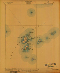 1906 Matinicus1906 Print · USGSCoastal Maine's most remote island communities are captured at the beginning of the twentieth century. Researchers can trace the early footprints of Matinicus and Criehaven, locate the Matinicus Rock LH, and follow the old Steamboat Route.4 unique versions available
 - 1906 Map of Tennant Harbor
 1906 Tennant Harbor1906 Print · USGSThe coastal waters of Knox County were a bustling corridor for maritime trade in the early 1900s. Genealogists and historians can trace the foundations of Tennant Harbor and Martinsville, while mapping the precise locations of offshore hazards like Roaring Bull and Metinic Island.4 unique versions available
 - 1906 Map of Monhegan
 1906 Monhegan1906 Print · USGSThe Maine coast at the turn of the century reveals a seafaring landscape of island outposts and sheltered harbors. Trace early maritime routes and family-named landmarks from Port Clyde to the isolated Monhegan Island.5 unique versions available
 - 1906 Map of Rockland
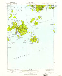
 1906 Rockland1906 Print · USGSCoastal Knox County comes alive in the first decade of the century, showing a bustling network of harbors and early transit systems. Genealogists and historians can trace family roots through crossroads like Blackinton Corners or investigate the old Wattons Mill and the Electric RR lines.7 unique versions available
 - 1913 Map of Waldoboro
 1913 Waldoboro1913 Print · USGSCoastal Lincoln and Knox counties come alive in this pre-war survey, showing a landscape of tightly-knit villages and rural school districts connected by the river and rail. Researchers can trace ancestral footprints at the Old Dutch Church, Winslows Mills, and the Benners Corner Cem.2 unique versions available
 - 1915 Map of Waldoboro
 1915 Waldoboro1915 Print · USGSCoastal Lincoln County is surveyed here in the early twentieth century, showing a landscape defined by tidal rivers and small farming hamlets. Genealogists can locate family-named sites like Flanders Corner and rural institutions such as the Branch School and Broad Cove PO.5 unique versions available
 - 1915 Map of Belfast, 1962 Print
 1915 Belfast1962 Print · USGSMid-coast Maine at the start of the twentieth century shows a landscape of busy harbor towns and high-altitude farms. Genealogists can trace family names across dozens of rural landmarks, from Holmes Mill and Simpsons Corner to the numerous remote schoolhouses like Bartlett School.
 - 1916 Map of Liberty
 1916 Liberty1916 Print · USGSMid-coast Maine at the start of the Great War was a patchwork of small townships and family farmsteads connected by narrow-gauge rails. Researchers can locate dozens of country schools and named crossroads such as The Kingdom, Hibberts Gore, and Woodmans Mills.6 unique versions available
 - 1917 Map of Belfast
 1917 Belfast1917 Print · USGSCoastal Waldo County hummed with maritime trade and small-scale milling during the years before the Great War. Researchers can trace ancestral property near Head of the Tide, locate district schoolhouses like Woods School, or follow the Maine Central Railroad into Belfast.6 unique versions available
 - 1941 Map of Belfast
 1941 Belfast1941 Print · USGSCoastal Waldo County at the start of the 1940s reveals a landscape of tidal rivers and bustling rural crossroads. Genealogists and historians can trace family locations through numerous landmarks like Allens Hall, Holmes Mill, and the Belfast & Moosehead Lake RR corridor.
 - 1941 Map of Rockland
 1941 Rockland1941 Print · USGSThe Knox County shoreline during the early 1940s features a detailed look at maritime life and coastal industry. Genealogists and historians can trace the foundations of Rockland, locate the Rockland Breakwater Lighthouse, and explore villages like South Thomaston and Wattons Mill.
 - 1941 Map of Waldoboro
 1941 Waldoboro1941 Print · USGSThe Medomak River valley and its surrounding coastal hills are captured here just as the war began. You can trace early twentieth-century rail connections at Glendon Station, find family-named crossroads like Whitney Corner, and locate local landmarks such as Winslows Mills.
 - 1941 Map of Vinalhaven, 1962 Print
 1941 Vinalhaven1962 Print · USGSPenobscot Bay is captured in high detail during the early 1940s, showing the intricate island communities of the Fox Islands. Researchers can trace family sites near Seaview Cem, locate maritime landmarks like Heron Neck L H, and explore the geography of Hurricane Island.3 unique versions available
 - 1942 Map of Liberty
 1942 Liberty1942 Print · USGSWaldo and Lincoln County lands are documented here just before mid-century, showing a landscape of rural schools and family-named corners. Genealogists can trace property near Hibberts Gore or locate ancestral homesites near Handy Sch and Montville Post Office.
 - 1942 Map of Deer Isle, 1958 Print
 1942 Deer Isle1958 Print · USGSCoastal Maine life in the 1940s centers on the granite industry and maritime trade routes throughout Deer Isle and the Penobscot Bay islands. Genealogists and historians can trace the foundations of local economies through the QUARRIES at Stonington and the many family-named landmarks like Greenlaw Neck or Conary Head.3 unique versions available
 - 1943 Map of Swans Island, 1958 Print
 1943 Swans Island1958 Print · USGSCoastal Hancock County at the height of the Second World War reveals a landscape of isolated island communities and maritime commerce. Genealogists and historians can trace family roots through the settlements of Atlantic, Minturn, and Frenchboro, or locate landmarks like the Blue Hill Bay LH and Little Duck I Bird Sanctuary.3 unique versions available
 - 1944 Map of Vinalhaven
 1944 Vinalhaven1944 Print · USGSThe Fox Islands of Maine are captured here during the 1940s, showing the intricate island-and-bay network of Penobscot Bay. Genealogists can trace early family sites like Fuller Cem and Browns Cem or locate maritime landmarks such as Browns Head LH.2 unique versions available
 - 1944 Map of Deer Isle
 1944 Deer Isle1944 Print · USGSPenobscot Bay and the Eggemoggin Reach appear here in the early 1940s, highlighting the granite and maritime hubs of the Maine coast. Genealogists and historians can locate family homes near Stonington, coastal Quarries, and landmarks like Forest Cem.2 unique versions available
Showing maps 1-25 of 244
Top cities of Knox County
- Rockland historical maps
- Warren historical maps
- Camden historical maps
- Rockport historical maps
- Thomaston historical maps
- Saint George historical maps
See more
Frequently asked questions
- What are the different types of historical maps available for Knox County?
- What is the oldest map of Knox County?
- Where can I purchase historical maps of Knox County for my home or office?
- Where can I download high-res historical maps of Knox County?
- Are there historical topographic maps available for Knox County?
- Is there historical aerial imagery available for Knox County?
- Where are historical maps of Knox County sourced from?