Old Maps of Muscle Ridge Township, Maine for Genealogy
Trace your family roots with 48 historic maps of Muscle Ridge Township. These high-res maps reveal old neighborhoods, homesites, landmarks, and streets — helping you uncover where your ancestors lived and how the area evolved over time.
- Explore historic neighborhoods: Identify where your relatives may have lived in the 1800s or 1900s.
- Compare maps over time: Trace the changes in streets, buildings, and landmarks for multi-generational research.
- Perfect for genealogy & ancestry research: Used by family historians and researchers to map out lineage and migration.
These maps are an incredible resource for exploring your personal connection to Muscle Ridge Township's past.
Muscle Ridge Township, ME maps
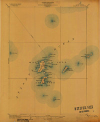
(48)- 1904 Map of Vinalhaven
 1904 Vinalhaven1904 Print · USGSThe Fox Islands and Penobscot Bay are captured here at a maritime peak, when steamboats and granite quarries drove the local economy. Researchers can trace historic ferry paths and find family landmarks like Coombs Hill, Browns Head L.H., and the settlement at North Haven.4 unique versions available
 - 1904 Map of Tenants Harbor, 1960 Print
 1904 Tenants Harbor1960 Print · USGSCoastal Maine at the turn of the century reveals a seafaring landscape shaped by granite islands and protected harbors. Genealogists and historians can trace old coastal settlements like Martinsville and Elmore or navigate the intricate Muscle Ridge Channel.
 - 1904 Map of Rockland, 1961 Print
 1904 Rockland1961 Print · USGSCoastal Knox County comes alive in this early twentieth-century survey of the harbor towns and the rocky Penobscot Bay shoreline. Trace the routes of the Maine Central RR and ELECTRIC lines to historic settlements like Blackinton Corners and Sharkeyville.
 - 1905 Map of Penobscot Bay
 1905 Penobscot Bay1905 Print · USGSThe Maine coastline at the dawn of the twentieth century was a bustling network of maritime trade and summer retreats. Genealogists and historians can trace the foundations of coastal life through the STEAMBOAT ROUTE, the Northport Camp Ground, and settlements like Sargentville.3 unique versions available
 - 1906 Map of Matinicus
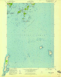
 1906 Matinicus1906 Print · USGSCoastal Maine's most remote island communities are captured at the beginning of the twentieth century. Researchers can trace the early footprints of Matinicus and Criehaven, locate the Matinicus Rock LH, and follow the old Steamboat Route.4 unique versions available
 - 1906 Map of Tennant Harbor
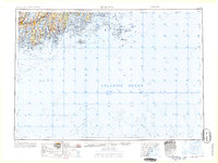
 1906 Tennant Harbor1906 Print · USGSThe coastal waters of Knox County were a bustling corridor for maritime trade in the early 1900s. Genealogists and historians can trace the foundations of Tennant Harbor and Martinsville, while mapping the precise locations of offshore hazards like Roaring Bull and Metinic Island.4 unique versions available
 - 1906 Map of Rockland
 1906 Rockland1906 Print · USGSCoastal Knox County comes alive in the first decade of the century, showing a bustling network of harbors and early transit systems. Genealogists and historians can trace family roots through crossroads like Blackinton Corners or investigate the old Wattons Mill and the Electric RR lines.7 unique versions available
 - 1941 Map of Rockland
 1941 Rockland1941 Print · USGSThe Knox County shoreline during the early 1940s features a detailed look at maritime life and coastal industry. Genealogists and historians can trace the foundations of Rockland, locate the Rockland Breakwater Lighthouse, and explore villages like South Thomaston and Wattons Mill.
 - 1941 Map of Vinalhaven, 1962 Print
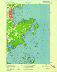
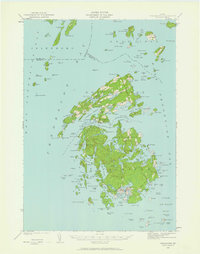 1941 Vinalhaven1962 Print · USGSPenobscot Bay is captured in high detail during the early 1940s, showing the intricate island communities of the Fox Islands. Researchers can trace family sites near Seaview Cem, locate maritime landmarks like Heron Neck L H, and explore the geography of Hurricane Island.3 unique versions available
 - 1944 Map of Vinalhaven
 1944 Vinalhaven1944 Print · USGSThe Fox Islands of Maine are captured here during the 1940s, showing the intricate island-and-bay network of Penobscot Bay. Genealogists can trace early family sites like Fuller Cem and Browns Cem or locate maritime landmarks such as Browns Head LH.2 unique versions available
 - 1948 Map of Bangor
 1948 Bangor1948 Print · USGSThe Maine coast and its industrial river valleys are captured here shortly after the war, showing the vital shipping and rail hubs of the late 1940s. Genealogists and historians can trace the tracks of the Maine Central RR connecting Bangor, Augusta, and Old Town.
 - 1948 Map of Bath
 1948 Bath1948 Print · USGSMid-coast Maine’s intricate shoreline and island outposts are captured here just after the war. Researchers can trace historic maritime settlements from Bath to Friendship and locate remote landmarks like Monhegan Island and Pemaquid Point.2 unique versions available
 - 1955 Map of Rockland, 1959 Print
 1955 Rockland1959 Print · USGSCoastal Maine in the mid-fifties comes alive in this survey of the Penobscot Bay shoreline and the Rockland harbor. Local historians can trace the aviation and maritime footprint of the era, from the Rockland Municipal Airport to the U S Coast Guard Sta and family-named cemeteries like Achorn Cem.5 unique versions available
 - 1955 Map of Hewett Island, 1959 Print
 1955 Hewett Island1959 Print · USGSCoastal Maine's intricate island chain is captured here in the mid-1950s, detailing the vital maritime passages and rugged archipelago south of Rockland. Researchers can trace the navigation aids of the era, from the U.S. Coast Guard Sta to landmarks like Hurricane Island and Whitehead Island.3 unique versions available
 - 1956 Map of Bangor, 1966 Print
 1956 Bangor1966 Print · USGSMid-century Maine comes alive in this survey of the rugged coast and river valleys during the 1950s. Genealogists and historians can trace the vital rail corridors of the Maine Central RR connecting timber towns like Old Town to the coast at Bar Harbor.3 unique versions available
 - 1956 Map of Bath, 1974 Print
 1956 Bath1974 Print · USGSCoastal Maine in the mid-fifties reveals a landscape of deep-water harbors and island outposts as the region transitioned from industrial roots to a summer destination. Genealogists can trace maritime families in Boothbay Harbor, Tenants Harbor, and on remote Monhegan Island.
 - 1957 Map of Bath
 1957 Bath1957 Print · USGSThe Maine coast in the mid-fifties is captured here, from the shipbuilding hubs of Bath and Brunswick to the granite reaches of Rockland. Researchers can trace the Maine Central RR line and remote island outposts like Monhegan Island and Matinicus Isle.
 - 1958 Map of Bath
 1958 Bath1958 Print · USGSCoastal Maine in the late fifties reveals a landscape of industrial river towns and remote island outposts. Genealogists and historians can trace the Maine Central RR through Bath, explore the islands of Muscongus Bay, or locate seafaring families at Pemaquid Point.
 - 1960 Map of Bangor
 1960 Bangor1960 Print · USGSCentral Maine in the sixties reveals a landscape of river-powered industry and sprawling coastal island chains. Researchers can trace the rail corridors of the Maine Central or locate mid-century aviation landmarks like Dow Air Force Base.
 - 1961 Map of Bangor
 1961 Bangor1961 Print · USGSMid-century Maine comes alive through its busy river ports and rocky archipelagoes during a period of steady maritime and rail commerce. Researchers can trace the path of the Maine Central railroad and locate coastal landmarks from Acadia National Park to Vinalhaven Island.
 - 1963 Map of Bath
 1963 Bath1963 Print · USGSThe Maine Midcoast in the early sixties remains a world of tidal rivers and jagged peninsulas tied to the sea. Genealogy and local history researchers can trace the rail lines of the Maine Central RR and locate offshore communities like Matinicus Island and Monhegan.2 unique versions available
 - 1965 Map of Bath
 1965 Bath1965 Print · USGSThe Midcoast Maine shoreline and its archipelago come alive in the mid-1960s, showing the region's deep reliance on river and rail. Researchers can trace historic harbor towns like Boothbay Harbor and Damariscotta, and locate coastal landmarks from Pemaquid Point to the Fort Popham Military Res.
 - 1982 Map of Leadbetter Island, 1983 Print
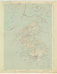
 1982 Leadbetter Island1983 Print · USGSPenobscot Bay islands like Vinalhaven and North Haven are shown in the early eighties as a dense network of granite heights and tidal channels. Researchers can locate coastal landmarks including the Lighthouse at Browns Head, the Outward Bound Sch, and the inland waters of Dyer Pond.
 - 1984 Map of Augusta
 1984 Augusta1984 Print · USGSMid-coast and central Maine were undergoing steady change in the mid-eighties as traditional river and coastal industries met expanding recreation. You can trace the Maine Central RR through Augusta or explore the rugged shoreline from Rockland Harbor up to Mount Megunticook.
 - 1985 Map of Matinicus
 1985 Matinicus1985 Print · USGSThe outer islands of Knox County are captured in the mid-1980s, highlighting the isolated settlements of the Gulf of Maine. Genealogists and maritime historians can locate homes and landmarks in Matinicus and Criehaven, or trace the shores of Ragged Island and Seal Island.
Showing maps 1-25 of 48
Top cities near Muscle Ridge Township
- Rockland historical maps
- Warren historical maps
- Camden historical maps
- Rockport historical maps
- Thomaston historical maps
- Saint George historical maps
See more
Frequently asked questions
- What are the different types of historical maps available for Muscle Ridge Township?
- What is the oldest map of Muscle Ridge Township?
- Where can I purchase historical maps of Muscle Ridge Township for my home or office?
- Where can I download high-res historical maps of Muscle Ridge Township?
- Are there historical topographic maps available for Muscle Ridge Township?
- Is there historical aerial imagery available for Muscle Ridge Township?
- Where are historical maps of Muscle Ridge Township sourced from?