1980s Maps of Dover-Foxcroft, Maine
Explore 8 historic maps of Dover-Foxcroft from the 1980s. These maps offer a rare glimpse into what life looked like during the 1980s — showing old roads, neighborhoods, homes, and landmarks that have changed or disappeared over time.
Whether you're researching your family's past, planning a metal detecting trip, or studying how Dover-Foxcroft's landscape evolved across the 1980s, these high-resolution maps are a powerful tool for exploring the history of this region.
- Focus on a specific era: All maps on this page are from the 1980s, giving you a focused view of this time period.
- See what’s changed: Compare century-old streets, trails, and buildings to today's modern landscape using overlays and satellite layers.
- Research with precision: Use these maps for genealogy, historical research, land use analysis, or educational projects.
- View, download, or print: Maps are fully viewable online in high resolution, and can be downloaded or printed for your own records.
Start exploring Dover-Foxcroft's history through authentic maps from the 1980s. This is your window into the past.
Dover-Foxcroft, ME maps
(8)- 1983 Map of Dover-Foxcroft, 1984 Print
 1983 Dover-Foxcroft1984 Print · USGSDover-Foxcroft and its surrounding townships are shown in the early eighties as the regional hub of Piscataquis County. Genealogists can locate family names and burial sites at Lee Cem and McAllister Cem, or trace the path of the Maine Central railroad.2 unique versions available
 - 1983 Map of South Sebec, 1984 Print
 1983 South Sebec1984 Print · USGSPiscataquis County remains a patchwork of riverfront settlements and managed woodlands in the early eighties. Genealogists and local historians can trace the foundations of Atkinson Mills or locate family plots at Hart Cem and Farnham Cem.
 - 1983 Map of Garland, 1984 Print
 1983 Garland1984 Print · USGSPenobscot and Piscataquis counties are shown in the early 1980s, revealing a landscape of historic mill sites and family-named crossroads. Genealogists and local historians can trace residents through Evergreen Cem and old settlements like Dover South Mills or Silvers Mills.2 unique versions available
 - 1983 Map of Charleston, 1984 Print
 1983 Charleston1984 Print · USGSThe rural highlands of Penobscot County are captured here in the early eighties, showcasing institutional landmarks and small-town hubs. Local historians can trace the grounds of Higgins Classical Institute, locate Rollins Mill, or follow the path of Stage Coach Road.2 unique versions available
 - 1984 Map of Sangerville
 1984 Sangerville1984 Print · USGSPiscataquis County's river-driven landscape is captured here in the mid-1980s as the communities of Sangerville and Guilford developed along the water. Genealogists can trace family locations at Jackson Corner or locate ancestors at Rural Grove Cem and the Old Railroad Grade.
 - 1986 Map of Dover-Foxcroft
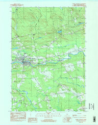
 1986 Dover-Foxcroft1986 Print · USGSPiscataquis County at the edge of the great Maine woods is documented here in the mid-1980s, centered on the river-and-rail hubs of the interior. Trace the industrial footprints of Dover South Mills, the rail yards at Brownville Junction, or the historic Katahdin Iron Works.
 - 1988 Map of Sebec Lake West
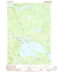 1988 Sebec Lake West1988 Print · USGSSebec Lake and the surrounding Piscataquis County wilderness are captured in the late eighties, showing a landscape of remote landings and deep woods. Researchers can locate vanished infrastructure and seasonal sites like Earley Landing, the Landing Strip, and Peaks-Kenny State Park.2 unique versions available
 - 1988 Map of Sebec Lake East
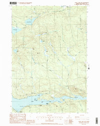 1988 Sebec Lake East1988 Print · USGSThe eastern reach of Sebec Lake is captured here in the late 1980s, revealing a landscape defined by its deep coves and shoreline landings. Genealogists and researchers can trace the vicinity of Barnard and waterfront sites like Greeleys Landing or Parson Landing.2 unique versions available
End of results
Showing maps 1-8 of 8
Top cities near Dover-Foxcroft
- Dexter historical maps
- Corinth historical maps
- Milo historical maps
- Corinna historical maps
- Saint Albans historical maps
- Charleston historical maps
See more
Top neighborhoods of Dover-Foxcroft
- South Dover historical maps
- Berrys Corner historical maps
- Dover South Mills historical maps
- Parson Landing historical maps
- Steadman Landing historical maps
- Greeleys Landing historical maps
See more
Frequently asked questions
- What are the different types of historical maps available for Dover-Foxcroft?
- What is the oldest map of Dover-Foxcroft?
- Where can I purchase historical maps of Dover-Foxcroft for my home or office?
- Where can I download high-res historical maps of Dover-Foxcroft?
- Are there historical topographic maps available for Dover-Foxcroft?
- Is there historical aerial imagery available for Dover-Foxcroft?
- Where are historical maps of Dover-Foxcroft sourced from?