Old Maps of Dover-Foxcroft, Maine for Metal Detecting
Plan your next treasure hunt with 61 historic maps of Dover-Foxcroft. Find old homesites, ghost towns, trails, and gathering spots that may be lost to time — perfect for identifying promising metal detecting locations.
- Locate forgotten sites: Uncover places like long-lost settlements, abandoned rail lines, or gathering spots.
- Plan better hunts: Use map overlays combined with LiDAR or satellite views to narrow in on historically rich areas.
- Made for detectorists: Thousands of hobbyists use these maps to discover relics, coins, and hidden history.
Use these historic maps to boost your research and find new opportunities beneath the surface of Dover-Foxcroft.
Dover-Foxcroft, ME maps
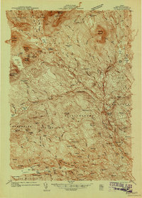
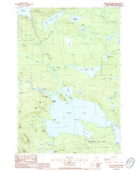
(61)- 1932 Map of Dover-Foxcroft
 1932 Dover-Foxcroft1932 Print · USGSPiscataquis and Penobscot counties are shown here in the early 1930s, a landscape defined by the Piscataquis River and rail-fed mill towns. Genealogists can trace family names through dozens of rural landmarks like Hurd Corner, Gould Cemetery, and the Higgins Classical Institute.4 unique versions available
 - 1933 Map of Guilford, 1958 Print
 1933 Guilford1958 Print · USGSPiscataquis County townships thrive along the river and rail lines of central Maine in the early thirties. Local historians can trace the foundations of Guilford, locate rural landmarks like Spooners Mill, and find family heritage at Storer Cem or Abbot Village Sta.5 unique versions available
 - 1935 Map of Dover-Foxcroft
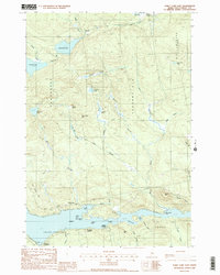
 1935 Dover-Foxcroft1935 Print · USGSThe Piscataquis River valley of central Maine is shown here in the 1930s, centered on the mill town of Dover-Foxcroft. Genealogists can trace family names at Rollins Mill, Foss Cem, and dozens of rural schoolhouses like Morrison Sch.2 unique versions available
 - 1937 Map of Guilford
 1937 Guilford1937 Print · USGSPiscataquis County industry and rural life are captured here in the mid-1930s as the river-and-rail economy thrived. Genealogists can trace family roots through numerous local schoolhouses and landmarks like Spooners Mill, Lows Bridge, and the Wassookeag Cem.2 unique versions available
 - 1940 Map of Sebec
 1940 Sebec1940 Print · USGSPiscataquis County in the early 1940s is captured here at a crossroads of the iron and timber industries. Researchers can locate the Katahdin Iron Works, trace the rail yards at Brownville Junction, and find rural schools like Williamsburg Sch.4 unique versions available
 - 1943 Map of Sebec
 1943 Sebec1943 Print · USGSPiscataquis County in the early 1940s is a landscape of iron works, timber rails, and remote schools. Genealogists and historians can trace the paths of the CANADIAN PACIFIC railroad and locate sites like the Williamsburg Sch, Katahdin Iron Works, and Barnard Corner.4 unique versions available
 - 1950 Map of Sebec Lake, 1952 Print
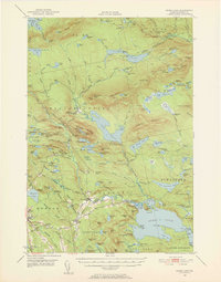 1950 Sebec Lake1952 Print · USGSMid-century Piscataquis County reveals a landscape of slate quarries, remote rail outposts, and wilderness trails just after the war. You can trace the mining history near Monson at Hillside Quarry or follow the Canadian Pacific line to the settlement at Onawa.7 unique versions available
 - 1954 Map of Millinocket, 1968 Print
 1954 Millinocket1968 Print · USGSMaine's North Woods and the Penobscot Valley are captured here during the mid-century era of logging and rail dominance. You can trace the path of the Bangor and Aroostook Railroad through timber towns like Millinocket, Mattawamkeag, and Silver Ridge.3 unique versions available
 - 1958 Map of Millinocket
 1958 Millinocket1958 Print · USGSMaine's North Woods and the Penobscot river valley are captured here in the mid-1950s, showing a landscape of timber, rail, and wild waters. Researchers can trace the legacy of the Canadian Pacific railroad and find historic settlements like Millinocket, Sherman Station, and Mattawamkeag.
 - 1960 Map of Millinocket
 1960 Millinocket1960 Print · USGSThe Maine North Woods and Penobscot River valley are captured at mid-century during the height of the paper milling era. Researchers can trace the Appalachian Trail near Mount Katardin or locate family roots in towns like Dover-Foxcroft and Milo.3 unique versions available
 - 1975 Map of Dover-Foxcroft NW, 1980 Print
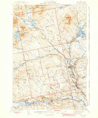
 1975 Dover-Foxcroft NW1980 Print · USGSPiscataquis County's river valley and rural crossroads are captured in this mid-seventies aerial survey. Researchers can trace the layout of historic settlements like Dover-Foxcroft and East Dover or locate family-named intersections such as Goffs Corner.
 - 1975 Map of Guilford NE, 1980 Print
 1975 Guilford NE1980 Print · USGSCentral Maine's forest and farm country is captured in the mid-1970s as the Piscataquis River flows past timberlands and small settlements. Researchers can trace land use patterns near Guilford Center, Dunham Corner, and East Sangerville.
 - 1975 Map of Dover-Foxcroft SE, 1980 Print
 1975 Dover-Foxcroft SE1980 Print · USGSCentral Maine agriculture and woodland are captured in the mid-seventies via aerial imagery. Researchers can trace rural property lines and historic crossroads like Hicks Corner, Rollins Mill, and West Charleston.
 - 1975 Map of Dover-Foxcroft SW, 1980 Print
 1975 Dover-Foxcroft SW1980 Print · USGSPenobscot County is captured in the mid-seventies, showing the intersection of Maine's timberlands and rural farming life. Genealogists and local historians can trace the precise 1975 building footprints at Dover South Mills, Garland, and Carr Corner.
 - 1975 Map of Dover-Foxcroft NE, 1980 Print
 1975 Dover-Foxcroft NE1980 Print · USGSPiscataquis County timberland and river settlements are captured in high-contrast detail during the mid-seventies. Local historians can trace the clearings of South Sebec and the small industrial footprint at Atkinson Mills along the riverbanks.
 - 1978 Map of Sebec Lake West, 1981 Print
 1978 Sebec Lake West1981 Print · USGSPiscataquis County timberlands and remote waters are captured in this late-seventies orthophoto survey. Researchers can trace the wild watercourse of Ship Pond Stream as it connects Lake Onawa to the expansive shores of Sebec Lake.
 - 1978 Map of Sebec Lake East, 1981 Print
 1978 Sebec Lake East1981 Print · USGSPiscataquis County appears in the late seventies as a landscape of dense timber and quiet lakeside settlements. Researchers can trace the rural layout of Barnard and Bowerbank or study the natural hydrology of Sebec Lake and Long Bog.
 - 1983 Map of Dover-Foxcroft, 1984 Print
 1983 Dover-Foxcroft1984 Print · USGSDover-Foxcroft and its surrounding townships are shown in the early eighties as the regional hub of Piscataquis County. Genealogists can locate family names and burial sites at Lee Cem and McAllister Cem, or trace the path of the Maine Central railroad.2 unique versions available
 - 1983 Map of South Sebec, 1984 Print
 1983 South Sebec1984 Print · USGSPiscataquis County remains a patchwork of riverfront settlements and managed woodlands in the early eighties. Genealogists and local historians can trace the foundations of Atkinson Mills or locate family plots at Hart Cem and Farnham Cem.
 - 1983 Map of Garland, 1984 Print
 1983 Garland1984 Print · USGSPenobscot and Piscataquis counties are shown in the early 1980s, revealing a landscape of historic mill sites and family-named crossroads. Genealogists and local historians can trace residents through Evergreen Cem and old settlements like Dover South Mills or Silvers Mills.2 unique versions available
 - 1983 Map of Charleston, 1984 Print
 1983 Charleston1984 Print · USGSThe rural highlands of Penobscot County are captured here in the early eighties, showcasing institutional landmarks and small-town hubs. Local historians can trace the grounds of Higgins Classical Institute, locate Rollins Mill, or follow the path of Stage Coach Road.2 unique versions available
 - 1984 Map of Sangerville
 1984 Sangerville1984 Print · USGSPiscataquis County's river-driven landscape is captured here in the mid-1980s as the communities of Sangerville and Guilford developed along the water. Genealogists can trace family locations at Jackson Corner or locate ancestors at Rural Grove Cem and the Old Railroad Grade.
 - 1986 Map of Dover-Foxcroft
 1986 Dover-Foxcroft1986 Print · USGSPiscataquis County at the edge of the great Maine woods is documented here in the mid-1980s, centered on the river-and-rail hubs of the interior. Trace the industrial footprints of Dover South Mills, the rail yards at Brownville Junction, or the historic Katahdin Iron Works.
 - 1988 Map of Sebec Lake West
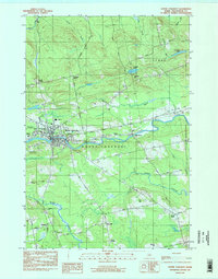
 1988 Sebec Lake West1988 Print · USGSSebec Lake and the surrounding Piscataquis County wilderness are captured in the late eighties, showing a landscape of remote landings and deep woods. Researchers can locate vanished infrastructure and seasonal sites like Earley Landing, the Landing Strip, and Peaks-Kenny State Park.2 unique versions available
 - 1988 Map of Sebec Lake East
 1988 Sebec Lake East1988 Print · USGSThe eastern reach of Sebec Lake is captured here in the late 1980s, revealing a landscape defined by its deep coves and shoreline landings. Genealogists and researchers can trace the vicinity of Barnard and waterfront sites like Greeleys Landing or Parson Landing.2 unique versions available
Showing maps 1-25 of 61
Top cities near Dover-Foxcroft
- Dexter historical maps
- Corinth historical maps
- Milo historical maps
- Corinna historical maps
- Saint Albans historical maps
- Charleston historical maps
See more
Top neighborhoods of Dover-Foxcroft
- South Dover historical maps
- Berrys Corner historical maps
- Dover South Mills historical maps
- Parson Landing historical maps
- Steadman Landing historical maps
- Greeleys Landing historical maps
See more
Frequently asked questions
- What are the different types of historical maps available for Dover-Foxcroft?
- What is the oldest map of Dover-Foxcroft?
- Where can I purchase historical maps of Dover-Foxcroft for my home or office?
- Where can I download high-res historical maps of Dover-Foxcroft?
- Are there historical topographic maps available for Dover-Foxcroft?
- Is there historical aerial imagery available for Dover-Foxcroft?
- Where are historical maps of Dover-Foxcroft sourced from?