Old Maps of T10 R15 WELS, Maine for Metal Detecting
Plan your next treasure hunt with 33 historic maps of T10 R15 WELS. Find old homesites, ghost towns, trails, and gathering spots that may be lost to time — perfect for identifying promising metal detecting locations.
- Locate forgotten sites: Uncover places like long-lost settlements, abandoned rail lines, or gathering spots.
- Plan better hunts: Use map overlays combined with LiDAR or satellite views to narrow in on historically rich areas.
- Made for detectorists: Thousands of hobbyists use these maps to discover relics, coins, and hidden history.
Use these historic maps to boost your research and find new opportunities beneath the surface of T10 R15 WELS.
T10 R15 WELS, ME maps
(33)- 1954 Map of Allagash Lake, 1955 Print
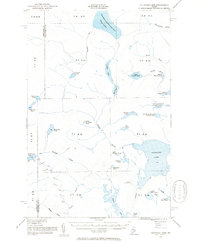 1954 Allagash Lake1955 Print · USGSNorthern Maine's remote timberlands are captured here in the mid-fifties, before modern roads reached these deep woods. Trace the wilderness waterways from Allagash Lake to the Allagash Lookout Tower and the remote St Francis Lake.2 unique versions available
 - 1954 Map of Presque Isle, 1968 Print
 1954 Presque Isle1968 Print · USGSNorth Woods logging and rail history come alive in this mid-century survey of the Maine-Quebec borderlands. Genealogists and historians can trace the Bangor and Aroostook railroad through timber hubs like Ashland, Smyrna Mills, and Presque Isle.2 unique versions available
 - 1955 Map of Clayton Lake, 1956 Print
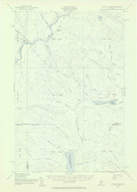 1955 Clayton Lake1956 Print · USGSThe North Maine Woods in the mid-1950s remained a remote timberland shaped by the St John River and expansive lakes. Researchers can locate specific backcountry outposts like Ninemile Bridge, Gannett Camp, and the Game Warden Camp along the winding logging roads.2 unique versions available
 - 1958 Map of Presque Isle
 1958 Presque Isle1958 Print · USGSThe Aroostook timber and potato country is captured here during the late fifties, showing the vital rail-to-river network of Northern Maine. Genealogists and historians can trace the Bangor & Aroostook RR through Mapleton and Ashland, or locate remote sites like Chamberlain Farm and Seven Islands.
 - 1960 Map of Presque Isle
 1960 Presque Isle1960 Print · USGSNorthern Maine during the mid-century was a land of timber, rails, and strategic airfields. Genealogists and historians can trace the growth of Presque Isle and Ashland or explore the remote northern reaches of Baxter State Park and Presque Isle AFB.3 unique versions available
 - 1961 Map of Allagash Lake, 1964 Print
 1961 Allagash Lake1964 Print · USGSThe Maine north woods in the early sixties remain a vast network of timberlands and interconnected waterways. Researchers can trace remote logging infrastructure and forestry outposts like the Lookout Tower on Allagash Mtn and the Forest Service Camp near Allagash Lake.3 unique versions available
 - 1986 Map of Chamberlain Lake
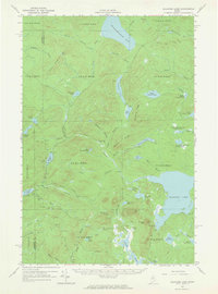
 1986 Chamberlain Lake1986 Print · USGSThe Maine North Woods in the mid-eighties appear here as a land of protected wilderness and logging heritage, centered on the Allagash Wilderness Waterway. Researchers can trace the historic Tramway at Chamberlain Lake and locate old outposts like Churchill Depot.
 - 1986 Map of Fool Brook, 1987 Print
 1986 Fool Brook1987 Print · USGSThe northern Maine woods at the intersection of Somerset and Piscataquis counties are captured here in the mid-eighties. Researchers can trace the logging infrastructure and water network around Ross Lake, including Gannett Camp and Fool Brook.
 - 1986 Map of Clayton Lake, 1987 Print
 1986 Clayton Lake1987 Print · USGSThe North Maine Woods in the 1980s were a landscape of remote timber operations and hidden waterways. Trace the logistics of the era through the Seaplane Base at Clayton Lake and the various Private Roads used for forest management.
 - 1989 Map of Upper Russell Pond
 1989 Upper Russell Pond1989 Print · USGSPiscataquis County remains a landscape of deep woods and interconnected waterways in the late eighties. Researchers can trace the timber-grid boundaries of T 9 R 14 WELS or locate remote points of interest like the Campground and the Shale Pit.
 - 1989 Map of Allagash Pond
 1989 Allagash Pond1989 Print · USGSThe Maine North Woods in the late 1980s reveal a wilderness of interconnected waterways and timber ridges at the Somerset and Piscataquis county line. Trace the remote reaches of Chemquasabamticook Lake and the headwaters of Allagash Pond.
 - 1993 Map of Clayton Lake, 1994 Print
 1993 Clayton Lake1994 Print · USGSThe North Woods along the Maine and Quebec border remained a vast wilderness of timber and water in the early nineties. Researchers can trace historic river crossings and remote outposts like Ninemile Bridge, Saint-Pamphile, and the Harvey Farm.
 - 1994 Map of Chamberlain Lake
 1994 Chamberlain Lake1994 Print · USGSThe North Maine Woods in the early nineties remained a network of logging outposts and protected waterways. You can trace the historic logging infrastructure at Churchill Depot, the portage at Tramway, and remote landings such as Telos Landing.
 - 2011 Map of Clayton Lake, 2011 Print
 2011 Clayton Lake2011 Print · USGSCovers T10 R15 WELS, including T10 R14 WELS, Clayton Lake Township, and other nearby areas
 - 2011 Map of Upper Russell Pond, 2011 Print
 2011 Upper Russell Pond2011 Print · USGSCovers T10 R15 WELS, including T9 R15 WELS, T9 R14 WELS, and other nearby areas
 - 2011 Map of Allagash Pond, 2011 Print
 2011 Allagash Pond2011 Print · USGSCovers T10 R15 WELS, including T9 R15 WELS, T8 R15 WELS, and other nearby areas
 - 2011 Map of Fool Brook, 2011 Print
 2011 Fool Brook2011 Print · USGSCovers T10 R15 WELS, including T10 R16 WELS, T11 R15 WELS, and other nearby areas
 - 2014 Map of Allagash Pond, 2014 Print
 2014 Allagash Pond2014 Print · USGSCovers T10 R15 WELS, including T9 R15 WELS, T8 R15 WELS, and other nearby areas
 - 2014 Map of Upper Russell Pond, 2014 Print
 2014 Upper Russell Pond2014 Print · USGSCovers T10 R15 WELS, including T9 R15 WELS, T9 R14 WELS, and other nearby areas
 - 2014 Map of Clayton Lake, 2014 Print
 2014 Clayton Lake2014 Print · USGSCovers T10 R15 WELS, including T10 R14 WELS, Clayton Lake Township, and other nearby areas
 - 2014 Map of Fool Brook, 2014 Print
 2014 Fool Brook2014 Print · USGSCovers T10 R15 WELS, including T10 R16 WELS, T11 R15 WELS, and other nearby areas
 - 2018 Map of Allagash Pond, 2018 Print
 2018 Allagash Pond2018 Print · USGSCovers T10 R15 WELS, including T9 R15 WELS, T8 R15 WELS, and other nearby areas
 - 2018 Map of Upper Russell Pond, 2018 Print
 2018 Upper Russell Pond2018 Print · USGSCovers T10 R15 WELS, including T9 R15 WELS, T9 R14 WELS, and other nearby areas
 - 2018 Map of Clayton Lake, 2018 Print
 2018 Clayton Lake2018 Print · USGSCovers T10 R15 WELS, including T10 R14 WELS, Clayton Lake Township, and other nearby areas
 - 2018 Map of Fool Brook, 2018 Print
 2018 Fool Brook2018 Print · USGSCovers T10 R15 WELS, including T10 R16 WELS, T11 R15 WELS, and other nearby areas
Showing maps 1-25 of 33
Frequently asked questions
- What are the different types of historical maps available for T10 R15 WELS?
- What is the oldest map of T10 R15 WELS?
- Where can I purchase historical maps of T10 R15 WELS for my home or office?
- Where can I download high-res historical maps of T10 R15 WELS?
- Are there historical topographic maps available for T10 R15 WELS?
- Is there historical aerial imagery available for T10 R15 WELS?
- Where are historical maps of T10 R15 WELS sourced from?