1940s Maps of Waldo County, Maine
Explore 12 historic maps of Waldo County from the 1940s. These maps offer a rare glimpse into what life looked like during the 1940s — showing old roads, neighborhoods, homes, and landmarks that have changed or disappeared over time.
Whether you're researching your family's past, planning a metal detecting trip, or studying how Waldo County's landscape evolved across the 1940s, these high-resolution maps are a powerful tool for exploring the history of this region.
- Focus on a specific era: All maps on this page are from the 1940s, giving you a focused view of this time period.
- See what’s changed: Compare century-old streets, trails, and buildings to today's modern landscape using overlays and satellite layers.
- Research with precision: Use these maps for genealogy, historical research, land use analysis, or educational projects.
- View, download, or print: Maps are fully viewable online in high resolution, and can be downloaded or printed for your own records.
Start exploring Waldo County's history through authentic maps from the 1940s. This is your window into the past.
Waldo County, ME maps
(12)- 1941 Map of Belfast
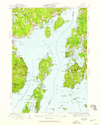
 1941 Belfast1941 Print · USGSCoastal Waldo County at the start of the 1940s reveals a landscape of tidal rivers and bustling rural crossroads. Genealogists and historians can trace family locations through numerous landmarks like Allens Hall, Holmes Mill, and the Belfast & Moosehead Lake RR corridor.
 - 1941 Map of Rockland
 1941 Rockland1941 Print · USGSThe Knox County shoreline during the early 1940s features a detailed look at maritime life and coastal industry. Genealogists and historians can trace the foundations of Rockland, locate the Rockland Breakwater Lighthouse, and explore villages like South Thomaston and Wattons Mill.
 - 1941 Map of Vassalboro, 1954 Print
 1941 Vassalboro1954 Print · USGSCentral Maine in the early 1940s reveals a landscape of lakeside settlements and scattered rural schoolhouses between the Kennebec and Sheepscot rivers. Genealogists can trace family roots through sites like Oak Grove Seminary, Friends Cem, and Weeks Mills.2 unique versions available
 - 1941 Map of Castine, 1959 Print
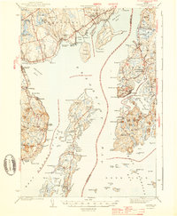
 1941 Castine1959 Print · USGSPenobscot Bay and its storied coastal villages appear here in the early 1940s, showing the intersection of maritime trade and rural Maine life. Genealogists and historians can trace the rail terminals at Mack Pt, local schools like Park Sch, and the historical site of Fort George.4 unique versions available
 - 1941 Map of Vinalhaven, 1962 Print
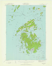 1941 Vinalhaven1962 Print · USGSPenobscot Bay is captured in high detail during the early 1940s, showing the intricate island communities of the Fox Islands. Researchers can trace family sites near Seaview Cem, locate maritime landmarks like Heron Neck L H, and explore the geography of Hurricane Island.3 unique versions available
 - 1942 Map of Liberty
 1942 Liberty1942 Print · USGSWaldo and Lincoln County lands are documented here just before mid-century, showing a landscape of rural schools and family-named corners. Genealogists can trace property near Hibberts Gore or locate ancestral homesites near Handy Sch and Montville Post Office.
 - 1942 Map of Bucksport
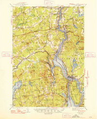
 1942 Bucksport1942 Print · USGSThe mid-century Penobscot River valley is captured here just as the river-and-rail economy defined local life. Genealogists and historians can trace family-named crossroads like Nealeys Corner and Ellingwoods Corner or locate the landmark Fort Knox and Prospect Ferry.
 - 1943 Map of Vassalboro
 1943 Vassalboro1943 Print · USGSCentral Maine in the early 1940s is a landscape of expansive lake systems and interconnected mill villages. Researchers can trace the heritage of local institutions like Oak Grove Seminary, the stop at Windsor Station, and the historic Friends Cem.
 - 1943 Map of Castine
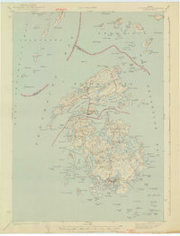
 1943 Castine1943 Print · USGSMid-century Penobscot Bay life is charted here during the early 1940s, from the historic streets of the mainland to the isolated island harbors. Genealogists can trace family connections at Bethany Chapel or locate the old Farnham Sch and the rail depot at Searsport Sta.3 unique versions available
 - 1944 Map of Vinalhaven
 1944 Vinalhaven1944 Print · USGSThe Fox Islands of Maine are captured here during the 1940s, showing the intricate island-and-bay network of Penobscot Bay. Genealogists can trace early family sites like Fuller Cem and Browns Cem or locate maritime landmarks such as Browns Head LH.2 unique versions available
 - 1948 Map of Bangor
 1948 Bangor1948 Print · USGSThe Maine coast and its industrial river valleys are captured here shortly after the war, showing the vital shipping and rail hubs of the late 1940s. Genealogists and historians can trace the tracks of the Maine Central RR connecting Bangor, Augusta, and Old Town.
 - 1948 Map of Bucksport
 1948 Bucksport1948 Print · USGSMid-coast Maine at the end of the 1940s reveals a bustling corridor of river commerce and rail transport along the Penobscot River. Researchers can trace old family lines at Wiswell Cem, locate the historic Fort Knox State Park, and follow the tracks of the Bangor and Aroostook through towns like Winterport.2 unique versions available
End of results
Showing maps 1-12 of 12
Top cities of Waldo County
- Belfast historical maps
- Winterport historical maps
- Searsport historical maps
- Lincolnville historical maps
- Unity historical maps
- Palermo historical maps
See more
Frequently asked questions
- What are the different types of historical maps available for Waldo County?
- What is the oldest map of Waldo County?
- Where can I purchase historical maps of Waldo County for my home or office?
- Where can I download high-res historical maps of Waldo County?
- Are there historical topographic maps available for Waldo County?
- Is there historical aerial imagery available for Waldo County?
- Where are historical maps of Waldo County sourced from?