Old Maps of Waldo County, Maine for Hiking & Exploration
Hike through history with 233 historic maps of Waldo County. Explore old trails, ghost towns, and forgotten backroads — perfect for outdoor adventurers and local explorers.
- Rediscover forgotten places: Map out old mining camps, roads, and footpaths that no longer exist on modern maps.
- Layer with modern tools: Combine with LiDAR or satellite views to plan hikes through historical terrain.
- Made for exploration: Popular among hikers, overlanders, and local history lovers.
Use these maps to find adventure and explore the hidden past of Waldo County.
Waldo County, ME maps
(233)- 1893 Map of Vassalboro
 1893 Vassalboro1893 Print · USGSMaine's heartland in the 1890s reveals a network of mill villages and lakeside settlements along the Kennebec River. Genealogists can trace early homesteads and landmarks near China Lake, North Vassalboro, and the rural crossroads of Weeks Mills.5 unique versions available
 - 1898 Map of Vassalboro, 1935 Print
 1898 Vassalboro1935 Print · USGSKennebec County at the close of the nineteenth century reveals a landscape of mill towns and interconnected lakes. Researchers can trace the early industrial footprint at Weeks Mills and Cooper Mills or follow the path of the Maine Central R.R. along the Kennebec River.
 - 1900 Map of Bucksport
 1900 Bucksport1900 Print · USGSThe Penobscot River corridor is captured here at the turn of the century as a vital artery for rail, river, and granite industries. Genealogists and historians can trace family-named corners and landmarks like Fort Knox, the Quarry at Mt Waldo, and Prospect Ferry.
 - 1902 Map of Bucksport
 1902 Bucksport1902 Print · USGSCoastal Maine at the turn of the century centered on the maritime and rail traffic of the Penobscot River valley. Genealogists and historians can trace old family settlements from Newburg Village to Orrington, alongside industrial landmarks like the Quarry and the historic fortifications at Fort Knox.6 unique versions available
 - 1902 Map of Castine
 1902 Castine1902 Print · USGSPenobscot Bay at the dawn of the 1900s shows a thriving maritime landscape of island settlements and harbor towns. Genealogists and historians can trace old homesteads and coastal landmarks near Ft. George, Northport Camp Ground, and the various landings of Islesboro.
 - 1904 Map of Castine
 1904 Castine1904 Print · USGSPenobscot Bay at the turn of the century shows a maritime landscape of bustling ports and emerging summer colonies. Genealogists and historians can trace old coastal settlements like Castine, locate the grounds of Ft. George, and follow the Steamboat Routes that linked the mainland to Dark Harbor.7 unique versions available
 - 1904 Map of Vinalhaven
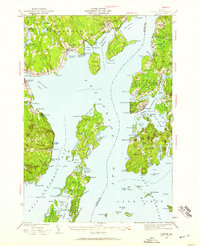
 1904 Vinalhaven1904 Print · USGSThe Fox Islands and Penobscot Bay are captured here at a maritime peak, when steamboats and granite quarries drove the local economy. Researchers can trace historic ferry paths and find family landmarks like Coombs Hill, Browns Head L.H., and the settlement at North Haven.4 unique versions available
 - 1904 Map of Rockland, 1961 Print
 1904 Rockland1961 Print · USGSCoastal Knox County comes alive in this early twentieth-century survey of the harbor towns and the rocky Penobscot Bay shoreline. Trace the routes of the Maine Central RR and ELECTRIC lines to historic settlements like Blackinton Corners and Sharkeyville.
 - 1905 Map of Penobscot Bay
 1905 Penobscot Bay1905 Print · USGSThe Maine coastline at the dawn of the twentieth century was a bustling network of maritime trade and summer retreats. Genealogists and historians can trace the foundations of coastal life through the STEAMBOAT ROUTE, the Northport Camp Ground, and settlements like Sargentville.3 unique versions available
 - 1906 Map of Rockland
 1906 Rockland1906 Print · USGSCoastal Knox County comes alive in the first decade of the century, showing a bustling network of harbors and early transit systems. Genealogists and historians can trace family roots through crossroads like Blackinton Corners or investigate the old Wattons Mill and the Electric RR lines.7 unique versions available
 - 1915 Map of Belfast, 1962 Print
 1915 Belfast1962 Print · USGSMid-coast Maine at the start of the twentieth century shows a landscape of busy harbor towns and high-altitude farms. Genealogists can trace family names across dozens of rural landmarks, from Holmes Mill and Simpsons Corner to the numerous remote schoolhouses like Bartlett School.
 - 1916 Map of Liberty
 1916 Liberty1916 Print · USGSMid-coast Maine at the start of the Great War was a patchwork of small townships and family farmsteads connected by narrow-gauge rails. Researchers can locate dozens of country schools and named crossroads such as The Kingdom, Hibberts Gore, and Woodmans Mills.6 unique versions available
 - 1917 Map of Belfast
 1917 Belfast1917 Print · USGSCoastal Waldo County hummed with maritime trade and small-scale milling during the years before the Great War. Researchers can trace ancestral property near Head of the Tide, locate district schoolhouses like Woods School, or follow the Maine Central Railroad into Belfast.6 unique versions available
 - 1926 Map of Burnham
 1926 Burnham1926 Print · USGSWaldo and Kennebec counties in the mid-1920s are captured here as a landscape of rural schoolhouses and family-named corners centered on the Sebasticook River. Genealogists can trace family roots through landmarks like Quaker Hill Church, the Freedom Town House, and dozens of district sites like Beech Hill School.3 unique versions available
 - 1930 Map of Pittsfield
 1930 Pittsfield1930 Print · USGSSomerset County in the early thirties reveals a network of farming hamlets and lakeside communities connected by rail and river. Genealogists can trace family names through landmarks like Todds Corner West Ripley PO, Nutter Cemetery, and Town Farm Sch.
 - 1932 Map of Brooks
 1932 Brooks1932 Print · USGSWaldo and Penobscot counties are shown here in the late twenties, organized around a series of hill peaks and the Belfast and Moosehead Lake RR. Researchers can locate dozens of country schools and mills, from Rollins Mills and Nickerson Mills to the East Thorndike Ch.3 unique versions available
 - 1932 Map of Pittsfield
 1932 Pittsfield1932 Print · USGSMaine's Sebasticook Valley thrived in the early 1930s as a hub of rail transport and rural commerce. Genealogists and historians can trace the many family-named schoolhouses and crossroads, from Lincoln Mills and Dixie Corner to the Wing Cemetery.3 unique versions available
 - 1933 Map of Pittsfield
 1933 Pittsfield1933 Print · USGSSomerset County in the early 1930s is a landscape of river-driven towns and remote farm schools connected by the Maine Central rail lines. Genealogy researchers can trace family landmarks like Goodwin Corner, the Wing Cemetery, and over a dozen schoolhouses including Merrill Sch.2 unique versions available
 - 1941 Map of Belfast
 1941 Belfast1941 Print · USGSCoastal Waldo County at the start of the 1940s reveals a landscape of tidal rivers and bustling rural crossroads. Genealogists and historians can trace family locations through numerous landmarks like Allens Hall, Holmes Mill, and the Belfast & Moosehead Lake RR corridor.
 - 1941 Map of Rockland
 1941 Rockland1941 Print · USGSThe Knox County shoreline during the early 1940s features a detailed look at maritime life and coastal industry. Genealogists and historians can trace the foundations of Rockland, locate the Rockland Breakwater Lighthouse, and explore villages like South Thomaston and Wattons Mill.
 - 1941 Map of Vassalboro, 1954 Print
 1941 Vassalboro1954 Print · USGSCentral Maine in the early 1940s reveals a landscape of lakeside settlements and scattered rural schoolhouses between the Kennebec and Sheepscot rivers. Genealogists can trace family roots through sites like Oak Grove Seminary, Friends Cem, and Weeks Mills.2 unique versions available
 - 1941 Map of Castine, 1959 Print
 1941 Castine1959 Print · USGSPenobscot Bay and its storied coastal villages appear here in the early 1940s, showing the intersection of maritime trade and rural Maine life. Genealogists and historians can trace the rail terminals at Mack Pt, local schools like Park Sch, and the historical site of Fort George.4 unique versions available
 - 1941 Map of Vinalhaven, 1962 Print
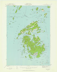 1941 Vinalhaven1962 Print · USGSPenobscot Bay is captured in high detail during the early 1940s, showing the intricate island communities of the Fox Islands. Researchers can trace family sites near Seaview Cem, locate maritime landmarks like Heron Neck L H, and explore the geography of Hurricane Island.3 unique versions available
 - 1942 Map of Liberty
 1942 Liberty1942 Print · USGSWaldo and Lincoln County lands are documented here just before mid-century, showing a landscape of rural schools and family-named corners. Genealogists can trace property near Hibberts Gore or locate ancestral homesites near Handy Sch and Montville Post Office.
 - 1942 Map of Bucksport
 1942 Bucksport1942 Print · USGSThe mid-century Penobscot River valley is captured here just as the river-and-rail economy defined local life. Genealogists and historians can trace family-named crossroads like Nealeys Corner and Ellingwoods Corner or locate the landmark Fort Knox and Prospect Ferry.
Showing maps 1-25 of 233
Top cities of Waldo County
- Belfast historical maps
- Winterport historical maps
- Searsport historical maps
- Lincolnville historical maps
- Unity historical maps
- Palermo historical maps
See more
Frequently asked questions
- What are the different types of historical maps available for Waldo County?
- What is the oldest map of Waldo County?
- Where can I purchase historical maps of Waldo County for my home or office?
- Where can I download high-res historical maps of Waldo County?
- Are there historical topographic maps available for Waldo County?
- Is there historical aerial imagery available for Waldo County?
- Where are historical maps of Waldo County sourced from?