1980s Maps of Waldo County, Maine
Explore 21 historic maps of Waldo County from the 1980s. These maps offer a rare glimpse into what life looked like during the 1980s — showing old roads, neighborhoods, homes, and landmarks that have changed or disappeared over time.
Whether you're researching your family's past, planning a metal detecting trip, or studying how Waldo County's landscape evolved across the 1980s, these high-resolution maps are a powerful tool for exploring the history of this region.
- Focus on a specific era: All maps on this page are from the 1980s, giving you a focused view of this time period.
- See what’s changed: Compare century-old streets, trails, and buildings to today's modern landscape using overlays and satellite layers.
- Research with precision: Use these maps for genealogy, historical research, land use analysis, or educational projects.
- View, download, or print: Maps are fully viewable online in high resolution, and can be downloaded or printed for your own records.
Start exploring Waldo County's history through authentic maps from the 1980s. This is your window into the past.
Waldo County, ME maps
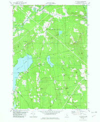
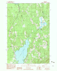
(21)- 1981 Map of Snow Mountain, 1982 Print
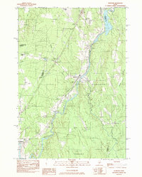
 1981 Snow Mountain1982 Print · USGSRural Penobscot and Waldo Counties come into focus during the late 1970s, showcasing a landscape of timbered hills and crossroads hamlets. Genealogists and local historians can trace family locations near Newburgh Village, Twining Cem, and the old Winterport Sta railroad stop.
 - 1982 Map of Hampden
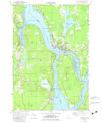
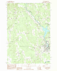
 1982 Hampden1982 Print · USGSThe Penobscot River valley in the early eighties shows a landscape of growing riverside towns and historic upland settlements. Genealogists can locate family landmarks from Dorothea Dix Park to several burying grounds including Riverview Cem and Evergreen Cem.
 - 1982 Map of Mt Waldo
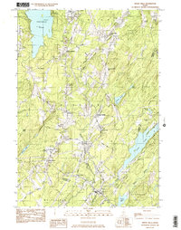
 1982 Mt Waldo1982 Print · USGSCoastal Waldo County inland from Penobscot Bay was a landscape of highland ridges and granite quarries in the early eighties. Researchers can trace rural school locations like Frankfort Sch and old family burial grounds such as Wiswell Cem or Nickerson Cem.2 unique versions available
 - 1982 Map of Bucksport
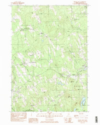
 1982 Bucksport1982 Print · USGSThe Penobscot River narrows into a vital maritime corridor at Bucksport in the early eighties. Researchers can trace the layout of Verona Island, the historic batteries of Fort Knox, and family sites at Silver Lake Cem or South Orland.2 unique versions available
 - 1982 Map of Snow Mountain
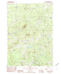
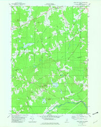 1982 Snow Mountain1982 Print · USGSPenobscot and Waldo counties come alive in the early eighties as a mosaic of small-town corners and rural hills. Genealogists and local historians can trace family plots at Chapman Cem, locate the Newburgh Sch, or explore the site of the Abandoned Airfield.2 unique versions available
 - 1982 Map of Dixmont
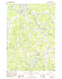
 1982 Dixmont1982 Print · USGSPenobscot and Waldo counties appear here in the early eighties as a landscape of crossroads hamlets and family farmsteads. Genealogists can trace rural roots through scattered sites like Sawyer Cem and Mt Holly Cem, or locate the Mount Harris Lookout Tower.2 unique versions available
 - 1982 Map of Unity, 1983 Print
 1982 Unity1983 Print · USGSWaldo County's agricultural and academic heartland is mapped here in the early eighties, centered on the village of Unity and the waters of Unity Pond. Genealogists and historians can locate numerous rural burial grounds like Saywood Cem, trace the Belfast and Moosehead Lake rail line, or find the Strawberry Fields Sch near Freedom.
 - 1982 Map of Burnham, 1983 Print
 1982 Burnham1983 Print · USGSWaldo and Somerset counties come into focus in the early 1980s, centered on the river-and-rail corridor of the Sebasticook River. Researchers can trace old property lines and rural life near Burnham, Nash Corner, and the Maine Central RR line.
 - 1982 Map of Pittsfield, 1983 Print
 1982 Pittsfield1983 Print · USGSCentral Maine in the early eighties shows a landscape defined by the Sebasticook River and the Maine Central railroad. Genealogists can trace family names through local landmarks like Manson Corner and Fuller Corner Cem.
 - 1982 Map of Albion, 1983 Print
 1982 Albion1983 Print · USGSAlbion and the Kennebec County interior are captured in the early eighties as a landscape of interconnected wetlands and small farm settlements. Researchers can trace family history through sites like the Besse Sch, Puddledock Hall, and the Quaker Hill Cem.
 - 1982 Map of Weeks Mills, 1983 Print
 1982 Weeks Mills1983 Print · USGSKennebec County in the early eighties is a landscape of river valleys and small crossroads settlements. Genealogists and historians can locate family burial grounds like Chadwick Hill Cem or trace the rural footprint of Erskine Academy and the Windsor Fairgrounds.2 unique versions available
 - 1982 Map of Brooks West, 1983 Print
 1982 Brooks West1983 Print · USGSWaldo County in the early eighties retains its traditional rural character, defined by the winding Belfast and Moosehead Lake railroad. Genealogists and historians can locate numerous small burial grounds like Wing Cem and Leonard Cem, or trace the development of crossroads like Jackson Corners.
 - 1982 Map of Newport, 1983 Print
 1982 Newport1983 Print · USGSThe rural landscape of Somerset and Penobscot counties is captured here in the early eighties, showing the towns of Newport and Pittsfield along the water. Genealogists can trace family locations at Dogtown, Miles Corner, and numerous rural Cem sites.2 unique versions available
 - 1982 Map of Unity Pond, 1983 Print
 1982 Unity Pond1983 Print · USGSThe rural crossroads of Waldo and Penobscot counties are captured here in the early eighties, just as conservation efforts like the Carlton Pond Waterfowl Production Area were established. Researchers can trace numerous family-named landmarks such as Gerrish Corner, Smarts Corner, and Troy Center.2 unique versions available
 - 1982 Map of Brooks East, 1983 Print
 1982 Brooks East1983 Print · USGSWaldo County in the early eighties retains its rural character, shaped by the Belfast and Moosehead Lake RR and the winding Marsh Stream. Genealogists and historians can locate several rural burial grounds like Village Cem and Mt Rest Cem, or trace local industry at Nickerson Mills.
 - 1982 Map of East Dixmont, 1983 Print
 1982 East Dixmont1983 Print · USGSPenobscot and Waldo counties meet in this early 1980s look at rural Maine as it transitioned between traditional farming and modern infrastructure. Genealogists can locate over a dozen family burial grounds including Bean Cem and Lufkin Cem, while tracing old routes like North Road.2 unique versions available
 - 1983 Map of North Haven West
 1983 North Haven West1983 Print · USGSMid-coast Maine’s maritime landscape is captured here in the early eighties, showing the intricate shorelines of Penobscot Bay. Genealogists and historians can trace coastal homesteads near Fuller Cem, landholdings on Seven Hundred Acre Island, and old routes like Main Road.
 - 1984 Map of Augusta
 1984 Augusta1984 Print · USGSMid-coast and central Maine were undergoing steady change in the mid-eighties as traditional river and coastal industries met expanding recreation. You can trace the Maine Central RR through Augusta or explore the rugged shoreline from Rockland Harbor up to Mount Megunticook.
 - 1985 Map of Bangor
 1985 Bangor1985 Print · USGSMid-Maine during the mid-eighties centers on the industrial pulse of the Penobscot River and its critical rail connections. Genealogists and historians can trace the development of river towns from Old Town to Ellsworth and locate regional landmarks like Fort Knox State Park.
 - 1985 Map of Bar Harbor
 1985 Bar Harbor1985 Print · USGSCoastal Hancock County in the mid-eighties shows an intricate landscape of island communities and protected wilderness. Trace the boundaries of Acadia National Park or locate seafaring hubs like Stonington and Bar Harbor.2 unique versions available
 - 1985 Map of Skowhegan, 1986 Print
 1985 Skowhegan1986 Print · USGSCentral Maine in the mid-eighties shows a landscape of river-driven industry and rural crossroads. Genealogists can trace family names and farmsteads near Lake George or along the Maine Central Railroad through Pittsfield and Burnham.2 unique versions available
End of results
Showing maps 1-21 of 21
Top cities of Waldo County
- Belfast historical maps
- Winterport historical maps
- Searsport historical maps
- Lincolnville historical maps
- Unity historical maps
- Palermo historical maps
See more
Frequently asked questions
- What are the different types of historical maps available for Waldo County?
- What is the oldest map of Waldo County?
- Where can I purchase historical maps of Waldo County for my home or office?
- Where can I download high-res historical maps of Waldo County?
- Are there historical topographic maps available for Waldo County?
- Is there historical aerial imagery available for Waldo County?
- Where are historical maps of Waldo County sourced from?