1930s Maps of Calvert County, Maryland
Explore 3 historic maps of Calvert County from the 1930s. These maps offer a rare glimpse into what life looked like during the 1930s — showing old roads, neighborhoods, homes, and landmarks that have changed or disappeared over time.
Whether you're researching your family's past, planning a metal detecting trip, or studying how Calvert County's landscape evolved across the 1930s, these high-resolution maps are a powerful tool for exploring the history of this region.
- Focus on a specific era: All maps on this page are from the 1930s, giving you a focused view of this time period.
- See what’s changed: Compare century-old streets, trails, and buildings to today's modern landscape using overlays and satellite layers.
- Research with precision: Use these maps for genealogy, historical research, land use analysis, or educational projects.
- View, download, or print: Maps are fully viewable online in high resolution, and can be downloaded or printed for your own records.
Start exploring Calvert County's history through authentic maps from the 1930s. This is your window into the past.
Calvert County, MD maps
(3)- 1936 Map of Leonardtown
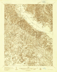 1936 Leonardtown1936 Print · USGSSt. Mary's County wharves and rural parishes are captured in detail during the mid-1930s. Genealogists can trace family footprints at Old All Faith Ch, identify old school sites like Maryland Springs Sch, or locate historic landings such as Williams Wharf.
 - 1938 Map of Prince Frederick
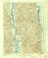 1938 Prince Frederick1938 Print · USGSCalvert County at the height of the 1930s reveals a Maryland landscape defined by tobacco farming and bay-front resorts. Researchers can locate vanished rural landmarks like the Cedar Hill Sch, explore the wharves at Deep Landing, or trace the early layout of Chesapeake Beach.3 unique versions available
 - 1939 Map of Leonardtown
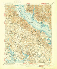 1939 Leonardtown1939 Print · USGSSouthern Maryland's river-oriented landscape is captured here in the late 1930s, centered on the community of Leonardtown. Genealogists can trace family roots through numerous country schools and landmarks like Bannaker Sch, St Andrews Ch, and the many landings along the Patuxent River.3 unique versions available
End of results
Showing maps 1-3 of 3
Top cities of Calvert County
- Chesapeake Ranch Estates historical maps
- Chesapeake Beach historical maps
- Solomons historical maps
- Drum Point historical maps
- Dunkirk historical maps
- Prince Frederick historical maps
See more
Frequently asked questions
- What are the different types of historical maps available for Calvert County?
- What is the oldest map of Calvert County?
- Where can I purchase historical maps of Calvert County for my home or office?
- Where can I download high-res historical maps of Calvert County?
- Are there historical topographic maps available for Calvert County?
- Is there historical aerial imagery available for Calvert County?
- Where are historical maps of Calvert County sourced from?