1980s Maps of Calvert County, Maryland
Explore 7 historic maps of Calvert County from the 1980s. These maps offer a rare glimpse into what life looked like during the 1980s — showing old roads, neighborhoods, homes, and landmarks that have changed or disappeared over time.
Whether you're researching your family's past, planning a metal detecting trip, or studying how Calvert County's landscape evolved across the 1980s, these high-resolution maps are a powerful tool for exploring the history of this region.
- Focus on a specific era: All maps on this page are from the 1980s, giving you a focused view of this time period.
- See what’s changed: Compare century-old streets, trails, and buildings to today's modern landscape using overlays and satellite layers.
- Research with precision: Use these maps for genealogy, historical research, land use analysis, or educational projects.
- View, download, or print: Maps are fully viewable online in high resolution, and can be downloaded or printed for your own records.
Start exploring Calvert County's history through authentic maps from the 1980s. This is your window into the past.
Calvert County, MD maps
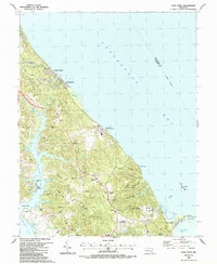
(7)- 1982 Map of Taylors Island
 1982 Taylors Island1982 Print · USGSThe Dorchester County coast is captured in the early eighties, showcasing the resilient island communities of the Maryland Eastern Shore. Genealogists can locate family landmarks like Bethlehem Ch, Smithville, and Old Trinity Cem among the marshlands.2 unique versions available
 - 1983 Map of Washington East, 1984 Print
 1983 Washington East1984 Print · USGSThe Chesapeake Bay region in the early eighties shows the Maryland capital and its suburbs meeting the maritime traditions of the Eastern Shore. Researchers can trace land patterns from Andrews Air Force Base to waterfront settlements like Oxford and Chesapeake Beach.2 unique versions available
 - 1983 Map of Leonardtown, 1984 Print
 1983 Leonardtown1984 Print · USGSSouthern Maryland and the Northern Neck of Virginia are shown in the early eighties as a mosaic of historic tidewater settlements and modern installations. Trace family roots and shoreline changes near St Marys City, Leonardtown, and Colonial Beach.2 unique versions available
 - 1984 Map of Barren Island
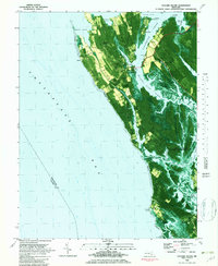
 1984 Barren Island1984 Print · USGSThe Dorchester County coastline in the mid-eighties shows a world of tidal marshes and remote island outposts. Trace the geography of Barren Island and its Landing Strip alongside the Cedar Point Lighthouse and Hooper Island Lighthouse.
 - 1987 Map of Cove Point
 1987 Cove Point1987 Print · USGSMaryland's Chesapeake shoreline is captured here during a period of industrial expansion in the late eighties. Researchers can trace historic local congregations at Middleham Chapel and St Paul Ch, alongside the prominent Lighthouse at Cove Point.
 - 1987 Map of Solomons Island
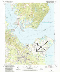 1987 Solomons Island1987 Print · USGSThe Patuxent River meets the Chesapeake Bay in the late eighties, showing a landscape shaped by military aviation and maritime life. Researchers can find coastal details from the Naval Air Test Center to local landmarks like Immaculate Heart of Mary Ch and Solomons.
 - 1989 Map of Washington
 1989 Washington1989 Print · USGSThe Potomac River valley and Chesapeake Bay are shown in comprehensive detail during the late 1980s. Genealogists and historians can trace the transition from urban Alexandria to the rural Northern Neck, locating landmarks like Mount Vernon and Stratford Hall.
End of results
Showing maps 1-7 of 7
Top cities of Calvert County
- Chesapeake Ranch Estates historical maps
- Chesapeake Beach historical maps
- Solomons historical maps
- Drum Point historical maps
- Dunkirk historical maps
- Prince Frederick historical maps
See more
Frequently asked questions
- What are the different types of historical maps available for Calvert County?
- What is the oldest map of Calvert County?
- Where can I purchase historical maps of Calvert County for my home or office?
- Where can I download high-res historical maps of Calvert County?
- Are there historical topographic maps available for Calvert County?
- Is there historical aerial imagery available for Calvert County?
- Where are historical maps of Calvert County sourced from?