1950s Maps of Calvert County, Maryland
Explore 9 historic maps of Calvert County from the 1950s. These maps offer a rare glimpse into what life looked like during the 1950s — showing old roads, neighborhoods, homes, and landmarks that have changed or disappeared over time.
Whether you're researching your family's past, planning a metal detecting trip, or studying how Calvert County's landscape evolved across the 1950s, these high-resolution maps are a powerful tool for exploring the history of this region.
- Focus on a specific era: All maps on this page are from the 1950s, giving you a focused view of this time period.
- See what’s changed: Compare century-old streets, trails, and buildings to today's modern landscape using overlays and satellite layers.
- Research with precision: Use these maps for genealogy, historical research, land use analysis, or educational projects.
- View, download, or print: Maps are fully viewable online in high resolution, and can be downloaded or printed for your own records.
Start exploring Calvert County's history through authentic maps from the 1950s. This is your window into the past.
Calvert County, MD maps
(9)- 1950 Map of Leonardtown, 1964 Print
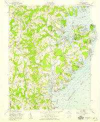
 1950 Leonardtown1964 Print · USGSMid-century Southern Maryland comes alive on this peninsula bounded by the Patuxent and Potomac estuaries. Genealogists and historians can trace family-named points and rural infrastructure through landmarks like St Andrews Ch, Williams Wharf, and Broomes Island.
 - 1953 Map of Mechanicsville, 1956 Print
 1953 Mechanicsville1956 Print · USGSSt. Mary's County in the early fifties shows a rural landscape defined by the Patuxent River and its tidal creeks. Genealogists and local historians can trace family-named points and early schools like Brent High Sch, St Joseph Sch, and the community of Mechanicsville.4 unique versions available
 - 1953 Map of Benedict, 1956 Print
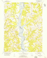
 1953 Benedict1956 Print · USGSThe Patuxent River valley in the early 1950s shows a landscape of tidal creeks and riverside landings across four Maryland counties. Genealogists and local historians can trace family-named sites like Holland Cliff, Leitch Wharf, and the settlement at Aquasco.5 unique versions available
 - 1953 Map of Lower Marlboro, 1956 Print
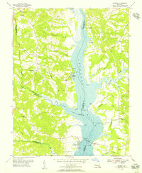
 1953 Lower Marlboro1956 Print · USGSThe Patuxent River corridor remains the focus of rural life in the 1950s, bridging the Prince George's and Calvert county lines. You can trace historic waterfront landmarks like Lyons Creek Wharf, Magruder Landing, and old country sites like St Johns Ch.6 unique versions available
 - 1953 Map of North Beach, 1956 Print
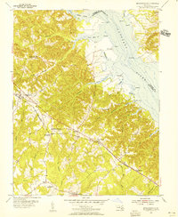
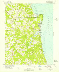 1953 North Beach1956 Print · USGSMaryland's western shore comes alive in the 1950s, showing a transition from rural Calvert County ridges to bustling bayside summer colonies. Genealogists and historians can trace the early footprints of Chesapeake Beach, the military presence at the U S Naval Reservation, and old country landmarks like All Saints Ch.4 unique versions available
 - 1953 Map of Prince Frederick, 1956 Print
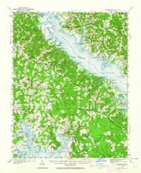
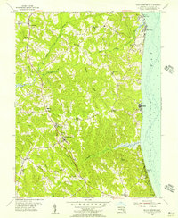 1953 Prince Frederick1956 Print · USGSCalvert County at mid-century remains a landscape of ridge-top settlements and quiet coastal reaches between the river and bay. Genealogists can locate family-named landmarks and rural congregations like St Pauls Cem, Emmanuel Ch, and the coastal cabins at Scientists Cliffs.4 unique versions available
 - 1957 Map of Bristol
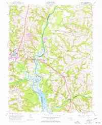 1957 Bristol1957 Print · USGSThe riverfront landings and rail corridors of Prince George's and Anne Arundel counties are well-defined in this mid-century survey. Genealogists and local historians can trace the foundations of Upper Marlboro and identify rural landmarks like Wesley Chapel, Waysons Corner, and the Marlboro Sta depot.5 unique versions available
 - 1957 Map of Deale, 1959 Print
 1957 Deale1959 Print · USGSCoastal Maryland at the dawn of the 1960s reveals a blend of historic river landings and new waterfront developments. Genealogists and local historians can locate legacy sites like St James Ch alongside seasonal destinations such as Camp Wabanna and Mimosa Cove.4 unique versions available
 - 1957 Map of Washington, 1966 Print
 1957 Washington1966 Print · USGSThe mid-Atlantic region during the mid-fifties and early sixties reveals a landscape of growing suburbs and vital military outposts. Researchers can trace historic river towns and shorelines from Alexandria to the Hooper Islands and St Clements Island.5 unique versions available
End of results
Showing maps 1-9 of 9
Top cities of Calvert County
- Chesapeake Ranch Estates historical maps
- Chesapeake Beach historical maps
- Solomons historical maps
- Drum Point historical maps
- Dunkirk historical maps
- Prince Frederick historical maps
See more
Frequently asked questions
- What are the different types of historical maps available for Calvert County?
- What is the oldest map of Calvert County?
- Where can I purchase historical maps of Calvert County for my home or office?
- Where can I download high-res historical maps of Calvert County?
- Are there historical topographic maps available for Calvert County?
- Is there historical aerial imagery available for Calvert County?
- Where are historical maps of Calvert County sourced from?