1910s Maps of Caroline County, Maryland
Explore 2 historic maps of Caroline County from the 1910s. These maps offer a rare glimpse into what life looked like during the 1910s — showing old roads, neighborhoods, homes, and landmarks that have changed or disappeared over time.
Whether you're researching your family's past, planning a metal detecting trip, or studying how Caroline County's landscape evolved across the 1910s, these high-resolution maps are a powerful tool for exploring the history of this region.
- Focus on a specific era: All maps on this page are from the 1910s, giving you a focused view of this time period.
- See what’s changed: Compare century-old streets, trails, and buildings to today's modern landscape using overlays and satellite layers.
- Research with precision: Use these maps for genealogy, historical research, land use analysis, or educational projects.
- View, download, or print: Maps are fully viewable online in high resolution, and can be downloaded or printed for your own records.
Start exploring Caroline County's history through authentic maps from the 1910s. This is your window into the past.
Caroline County, MD maps
(2)- 1915 Map of Seaford
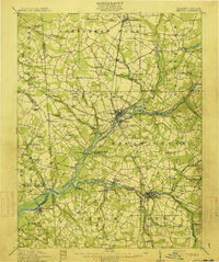 1915 Seaford1915 Print · USGSCoastal Sussex County and the Maryland borderlands are seen here at a time when river traffic and rail lines were the lifeblood of the region. Researchers can trace the Steamboat Route up to Seaford or locate ancestral sites like Cannons Ferry and Cokesbury School.4 unique versions available
 - 1918 Map of Harrington
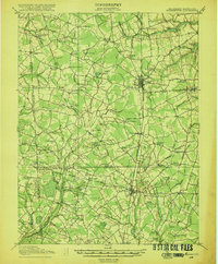 1918 Harrington1918 Print · USGSThe Kent and Sussex County borderlands at the end of the Great War reveal a landscape of busy rail corridors and small schoolhouses. Researchers can trace the legacy of rural education at Union Chapel School or locate family roots near Harrington and Hickman.4 unique versions available
End of results
Showing maps 1-2 of 2
Top cities of Caroline County
- Denton historical maps
- Federalsburg historical maps
- Greensboro historical maps
- Ridgely historical maps
- Preston historical maps
- Goldsboro historical maps
See more
Frequently asked questions
- What are the different types of historical maps available for Caroline County?
- What is the oldest map of Caroline County?
- Where can I purchase historical maps of Caroline County for my home or office?
- Where can I download high-res historical maps of Caroline County?
- Are there historical topographic maps available for Caroline County?
- Is there historical aerial imagery available for Caroline County?
- Where are historical maps of Caroline County sourced from?