1940s Maps of Caroline County, Maryland
Explore 18 historic maps of Caroline County from the 1940s. These maps offer a rare glimpse into what life looked like during the 1940s — showing old roads, neighborhoods, homes, and landmarks that have changed or disappeared over time.
Whether you're researching your family's past, planning a metal detecting trip, or studying how Caroline County's landscape evolved across the 1940s, these high-resolution maps are a powerful tool for exploring the history of this region.
- Focus on a specific era: All maps on this page are from the 1940s, giving you a focused view of this time period.
- See what’s changed: Compare century-old streets, trails, and buildings to today's modern landscape using overlays and satellite layers.
- Research with precision: Use these maps for genealogy, historical research, land use analysis, or educational projects.
- View, download, or print: Maps are fully viewable online in high resolution, and can be downloaded or printed for your own records.
Start exploring Caroline County's history through authentic maps from the 1940s. This is your window into the past.
Caroline County, MD maps
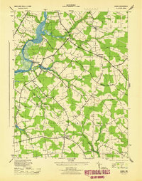
(18)- 1942 Map of Trappe, 1962 Print
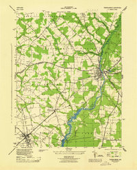
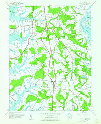 1942 Trappe1962 Print · USGSMaryland's Eastern Shore appears here in the early 1940s, showing a landscape defined by tidal necks and the Pennsylvania railroad. Genealogists and local historians can trace small settlements like Stumptown, rural sites such as Union Ch, and several family burial grounds including Merrick Cem.3 unique versions available
 - 1943 Map of Trappe
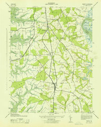 1943 Trappe1943 Print · USGSCoastal Talbot County in the early 1940s is mapped here in detail, showing a landscape of fertile necks and winding tidal creeks. Researchers can trace family roots at Union Church or Merrick Cemetery and locate rail history at Trappe Station.
 - 1944 Map of Denton
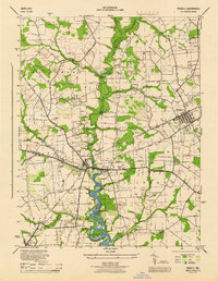
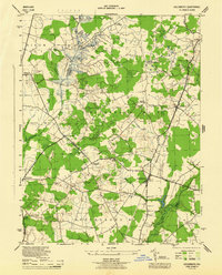
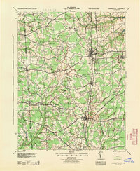
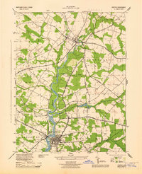 1944 Denton1944 Print · USGSCaroline County's riverfront and agricultural heartland are shown here in the mid-1940s as the Choptank River economy transition from water to rail and road. Genealogists can trace family landmarks like Sewell Mills, Cokers Cem, and the Lockerman Sch in Denton.5 unique versions available
 - 1944 Map of Preston
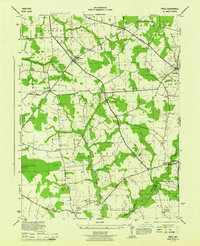
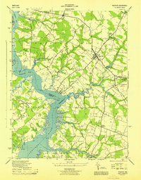 1944 Preston1944 Print · USGSMaryland's Eastern Shore transitions from river commerce to rail-driven agriculture during the mid-forties. Genealogists can trace family roots through numerous local landmarks, from Wright Wharf to country churches like Coppins Chapel and Bethesda Ch.3 unique versions available
 - 1944 Map of Federalsburg
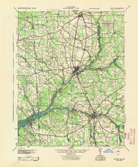
 1944 Federalsburg1944 Print · USGSThe Eastern Shore of Maryland in the mid-1940s centered on the rail and river trade through Federalsburg and Hurlock. Family historians can trace rural roots through landmarks like Solomons Temple Church, the ferry crossing at Harrison Ferry Bridge, and early railroad corridors.3 unique versions available
 - 1944 Map of Price
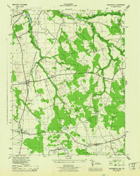
 1944 Price1944 Print · USGSQueen Anne's County was a landscape of quiet agricultural hamlets and country parishes during the mid-forties. Genealogists and local historians can trace family roots through landmarks like Bethany Church, the St Gertrude Academy, or the settlement of Price along the Pennsylvania railroad line.4 unique versions available
 - 1944 Map of Ridgely
 1944 Ridgely1944 Print · USGSThe Eastern Shore counties of Caroline, Queen Anne's, and Talbot meet along the Tuckahoe Creek during the final years of the war. Researchers can trace the rail corridor of the Baltimore and Eastern and find local landmarks like Adolph Landing and Allan Church.4 unique versions available
 - 1944 Map of Seaford
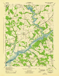
 1944 Seaford1944 Print · USGSWestern Sussex County is shown at a mid-century peak of river and rail commerce, featuring the Nanticoke River Steamboat Route. Genealogists can trace family footprints across dozens of local school sites and river crossings like Cannons Ferry and Baileys Landing.
 - 1944 Map of Hobbs
 1944 Hobbs1944 Print · USGSCaroline County is documented here during the war years, showing a landscape of small crossroads settlements and river landings. Trace the location of family homes and local landmarks like Todds Chapel, American Corners, and the Old RR Grade near Hobbs.3 unique versions available
 - 1944 Map of Goldsboro
 1944 Goldsboro1944 Print · USGSCaroline County and the surrounding Eastern Shore agricultural lands are shown here in the mid-1940s. Genealogists and local historians can trace the rail-side growth of Goldsboro and Henderson or locate rural sites like Ervings Chapel and Bethel School.4 unique versions available
 - 1944 Map of Fowling Creek
 1944 Fowling Creek1944 Print · USGSMaryland's Eastern Shore during the mid-1940s highlights a landscape deeply tied to its river landings and country parishes. Genealogists and local historians can trace family roots through Mt Zion Ch and Cem, Bells Chapel, and old wharves like Ganey Wharf.4 unique versions available
 - 1944 Map of Sudlersville
 1944 Sudlersville1944 Print · USGSThe rural borderlands of Maryland and Delaware are captured here in the mid-1940s, centered on the rail corridor at Sudlersville. Researchers can trace old family crossroads like Schenk Corners or locate country sites such as Prices Chapel and Busicks Ch.
 - 1944 Map of Harrington
 1944 Harrington1944 Print · USGSThe Delaware-Maryland borderlands in the mid-1940s are defined here by the Pennsylvania rail line and a high density of rural schoolhouses. Genealogists can trace family names across dozens of crossroads like Minners Corners or locate remote landmarks such as Union Chapel Sch and White Marsh.
 - 1946 Map of Wilmington, 1948 Print
 1946 Wilmington1948 Print · USGSThe Delaware Valley and Jersey Shore emerge in this mid-century portrait of a region defined by river commerce and seaside growth. Genealogists and historians can trace the rail networks of the Pennsylvania Railroad, locate early airfields like Dover Airpark, and find river defenses at Fort Delaware.2 unique versions available
 - 1946 Map of Salisbury, 1948 Print
 1946 Salisbury1948 Print · USGSThe Delmarva Peninsula in the late nineteen-forties shows a landscape defined by its deep river arteries and emerging coastal defenses. Genealogists and historians can trace rail-connected towns like Federalsburg or locate maritime landmarks such as the Ocean City Seaplane Base and Fort Miles Military Reservation.4 unique versions available
 - 1947 Map of Salisbury, 1948 Print
 1947 Salisbury1948 Print · USGSThe Delmarva Peninsula in the late forties reveals a coastal landscape of maritime defense and growing seaside towns. Trace the post-war footprint of Salisbury, the strategic Fort Miles Military Reservation, and the Ocean City Seaplane Base.
 - 1948 Map of Washington
 1948 Washington1948 Print · USGSThe Potomac and Chesapeake regions in the late 1940s reveal a landscape of expanding military reach and deep-rooted Tidewater settlements. Trace old rail corridors like the Richmond Fredericksburg & Potomac RR or locate landmarks like the Wakefield Washington Monument and St. Marys College.2 unique versions available
 - 1948 Map of Salisbury, 1951 Print
 1948 Salisbury1951 Print · USGSThe Delmarva Peninsula in the late 1940s is shown here as a busy network of rail-towns and coastal outposts. Researchers can trace the legacy of the Pennsylvania Railroad through inland hubs like Georgetown or the maritime reaches of Crisfield and Cape May.
End of results
Showing maps 1-18 of 18
Top cities of Caroline County
- Denton historical maps
- Federalsburg historical maps
- Greensboro historical maps
- Ridgely historical maps
- Preston historical maps
- Goldsboro historical maps
See more
Frequently asked questions
- What are the different types of historical maps available for Caroline County?
- What is the oldest map of Caroline County?
- Where can I purchase historical maps of Caroline County for my home or office?
- Where can I download high-res historical maps of Caroline County?
- Are there historical topographic maps available for Caroline County?
- Is there historical aerial imagery available for Caroline County?
- Where are historical maps of Caroline County sourced from?