1950s Maps of Caroline County, Maryland
Explore 12 historic maps of Caroline County from the 1950s. These maps offer a rare glimpse into what life looked like during the 1950s — showing old roads, neighborhoods, homes, and landmarks that have changed or disappeared over time.
Whether you're researching your family's past, planning a metal detecting trip, or studying how Caroline County's landscape evolved across the 1950s, these high-resolution maps are a powerful tool for exploring the history of this region.
- Focus on a specific era: All maps on this page are from the 1950s, giving you a focused view of this time period.
- See what’s changed: Compare century-old streets, trails, and buildings to today's modern landscape using overlays and satellite layers.
- Research with precision: Use these maps for genealogy, historical research, land use analysis, or educational projects.
- View, download, or print: Maps are fully viewable online in high resolution, and can be downloaded or printed for your own records.
Start exploring Caroline County's history through authentic maps from the 1950s. This is your window into the past.
Caroline County, MD maps
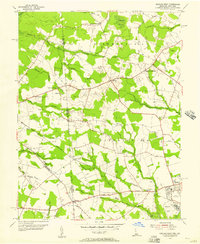
(12)- 1951 Map of Barclay
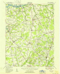 1951 Barclay1951 Print · USGSMid-century Queen Anne's County is captured here in its prime agricultural era, just as modern drainage was reshaping the Delmarva landscape. Genealogists can trace family names at Hackett Corners or locate landmarks like St Gertrude Academy and the Pennsylvania rail line.2 unique versions available
 - 1953 Map of Sudlersville, 1955 Print
 1953 Sudlersville1955 Print · USGSThe Maryland-Delaware borderlands near the mid-century were defined by a rhythmic landscape of family crossroads and rail-side towns. Genealogists and historians can trace the foundations of local communities through sites like Holdens Ch, Unicorn Mill Pond, and the scattered settlements of Duhamel Corners and Barclay.2 unique versions available
 - 1955 Map of Wilmington
 1955 Wilmington1955 Print · USGSThe Delaware Valley and Jersey Shore are seen here during the mid-fifties era of rapid suburban expansion and highway development. You can trace the path of the New Jersey Turnpike, locate the Fort Dix Military Reservation, or explore the rail networks of the Pennsylvania Railroad.
 - 1955 Map of Burrsville, 1956 Print
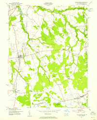
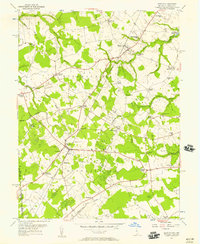
 1955 Burrsville1956 Print · USGSThe Kent and Caroline county borderlands in the mid-1950s reveal a landscape of interconnected farming hamlets and parish churches. Genealogists can trace family footprints at Hollandsville, Melvin Crossroads, and Manship Ch.2 unique versions available
 - 1955 Map of Hickman, 1957 Print
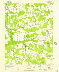
 1955 Hickman1957 Print · USGSMid-century Sussex County comes into focus in the mid-fifties, showing the farming and drainage patterns along the Maryland border. Genealogists can trace family footprints near Smithville, Dublin Hill, and country houses of worship like Trinity Ch.2 unique versions available
 - 1955 Map of Seaford West, 1957 Print
 1955 Seaford West1957 Print · USGSSussex County, Delaware, is captured in the mid-fifties at the Maryland state line, showing a landscape of small crossroads and creek-side industry. Researchers can trace family roots through Old Liberty Ch, Wrights Cem, and the rural Blocksom Sch.2 unique versions available
 - 1955 Map of Kenton, 1957 Print
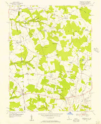
 1955 Kenton1957 Print · USGSWestern Kent County in the mid-1950s is a landscape of thriving rural crossroads and country schools. Genealogists and local historians can trace family-named landmarks like Pearsons Corner, Seven Hickories, and Downes Chapel, alongside the early Lash Airfield.3 unique versions available
 - 1956 Map of Marydel, 1957 Print
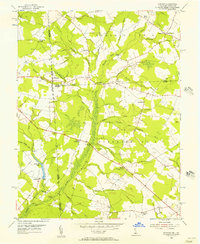
 1956 Marydel1957 Print · USGSThe Maryland-Delaware borderlands come alive in this mid-century survey of rural farm districts and marshland drainage networks. Genealogists can trace family footprints near Thomas Chapel, the Oak Point Sch, and the waters of the Mud Millpond and Choptank River.2 unique versions available
 - 1957 Map of Wilmington
 1957 Wilmington1957 Print · USGSThe mid-Atlantic coastal plain comes alive in the mid-fifties as the New Jersey Turnpike and Garden State Parkway redefine travel. Researchers can trace the rail-to-road transition and find landmarks like Ship John Shoal Light and the Fort Dix Military Reservation.2 unique versions available
 - 1957 Map of Salisbury
 1957 Salisbury1957 Print · USGSThe Delmarva Peninsula in the mid-1950s reveals a landscape of coastal defenses and rail-driven commerce. Researchers can trace the Pennsylvania railroad lines or locate historic landmarks like the Fenwick Island Lighthouse and St Martin church.
 - 1957 Map of Washington, 1966 Print
 1957 Washington1966 Print · USGSThe mid-Atlantic region during the mid-fifties and early sixties reveals a landscape of growing suburbs and vital military outposts. Researchers can trace historic river towns and shorelines from Alexandria to the Hooper Islands and St Clements Island.5 unique versions available
 - 1959 Map of Wilmington
 1959 Wilmington1959 Print · USGSThe Delaware Valley and Jersey Shore are seen here in the late fifties, during a period of massive suburban and highway expansion. Researchers can trace mid-century infrastructure like the N J Turnpike or locate coastal landmarks from Barnegat Bay to the Maurice River.3 unique versions available
End of results
Showing maps 1-12 of 12
Top cities of Caroline County
- Denton historical maps
- Federalsburg historical maps
- Greensboro historical maps
- Ridgely historical maps
- Preston historical maps
- Goldsboro historical maps
See more
Frequently asked questions
- What are the different types of historical maps available for Caroline County?
- What is the oldest map of Caroline County?
- Where can I purchase historical maps of Caroline County for my home or office?
- Where can I download high-res historical maps of Caroline County?
- Are there historical topographic maps available for Caroline County?
- Is there historical aerial imagery available for Caroline County?
- Where are historical maps of Caroline County sourced from?